San Francisco de Sangayaico District
| San Francisco de Sangayaico District | |
|---|---|
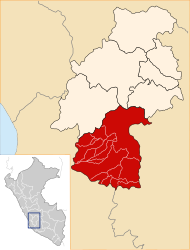
 The district of San Francisco de Sangayaico is located southwest-central in the province of Huaytará (marked in red) |
|
| Basic data | |
| Country | Peru |
| region | Huancavelica |
| province | Huaytará |
| Seat | San Francisco de Sangayaico |
| surface | 78.5 km² |
| Residents | 955 (2017) |
| density | 12 inhabitants per km² |
| founding | January 26, 1956 |
| ISO 3166-2 | PE-HUV |
| politics | |
| Alcalde District | Javier German Buleje Sanchez (2019-2022) |
Coordinates: 13 ° 47 ′ 42 " S , 75 ° 14 ′ 57" W.
The district of San Francisco de Sangayaico is located in the province of Huaytará in the region of Huancavelica in south- central Peru . The district was established on January 26, 1956. It has an area of 78.5 km². The 2017 census counted 955 inhabitants. In 1993 the population was 1400, in 2007 it was 821. The seat of the district administration is the 3380 m high town of San Francisco de Sangayaico with 305 inhabitants (as of 2017). San Francisco de Sangayaico is located 24 km south-southeast of the provincial capital Huaytará .
Geographical location
The district of San Francisco de Sangayaico is located in the Peruvian Western Cordillera, southwest-central in the province of Huaytará. It lies on the north bank of the west flowing Río Olaya, the left source river of the Río Ica .
The district of San Francisco de Sangayaico borders in the south with the district Santiago de Chocorvos and in the north with the district Santo Domingo de Capillas .
Localities
In addition to the main town, the district has the following larger towns:
- Santa Rosa de Acora
Web links
- Peru: Huancavelica region (provinces and districts) at www.citypopulation.de
- INEI Perú