San Juan del Cesar
| San Juan del Cesar | ||
|---|---|---|
|
Coordinates: 10 ° 46 ′ N , 73 ° 0 ′ W San Juan del Cesar on the map of Colombia
|
||
|
Location of the municipality of San Juan del Cesar on the map of La Guajira
|
||
| Basic data | ||
| Country | Colombia | |
| Department | La Guajira | |
| City foundation | 1701 | |
| Residents | 39,472 (2019) | |
| City insignia | ||
| Detailed data | ||
| surface | 1415 km 2 | |
| Population density | 28 people / km 2 | |
| height | 250 m | |
| City Presidency | Luis Manuel Daza Mendoza (2016-2019) | |
| Website | ||
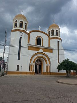
| Church in San Juan del Cesar | ||
San Juan del Cesar is a municipality ( municipio ) in the department of La Guajira in Colombia .
geography
San Juan del Cesar is located in the south of the La Guajira department , about 82 kilometers north of Valledupar , the capital of the adjacent Cesar department . The municipality borders on Riohacha and Dibulla to the north, Villanueva and El Molino to the south, Distracción , Fonseca and Venezuela to the east and Valledupar in Cesar to the southwest.
population
The municipality of San Juan del Cesar has 39,472 inhabitants, of which 26,372 live in the urban part (cabecera municipal) of the municipality (as of 2019).
history
The city goes back to an encomienda in colonial times, which was initially called La Porquera . Since 1701 the place was no longer an encomienda and was converted into a parish with the name San Juan Bautista ( John the Baptist ). After independence, the place became the capital of the canton of Cesar under the name Villa de San Juan del Cesar. Since 1886 San Juan del Cesar is a municipality in the current sense with the current name.
Personalities
- Diomedes Díaz (1957–2013), singer and composer of Vallenato music
Web links
- Alcaldía de San Juan Del Cesar - La Guajira. Alcaldía de San Juan del Cesar - La Guajira, accessed on June 11, 2019 (Spanish, website of the municipality of San Juan del Cesar).
Individual evidence
- ↑ a b Nuestro municipio. Alcaldía de San Juan del Cesar - La Guajira, accessed June 11, 2019 (Spanish, community information).
- ↑ ESTIMACIONES DE POBLACIÓN 1985 - 2005 Y PROYECCIONES DE POBLACIÓN 2005 - 2020 TOTAL DEPARTAMENTAL POR ÁREA. (Excel; 1.72 MB) DANE, May 11, 2011, accessed on June 11, 2019 (Spanish, extrapolation of the population of Colombia).


