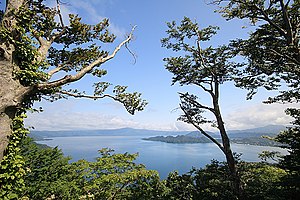
Towada (Aomori)
| Towada-shi 十 和田 市 |
||
|---|---|---|
| Geographical location in Japan | ||
|
|
||
| Region : | Tōhoku | |
| Prefecture : | Aomori | |
| Coordinates : | 40 ° 37 ' N , 141 ° 12' E | |
| Basic data | ||
| Surface: | 725.67 km² | |
| Residents : | 61,058 (June 1, 2019) |
|
| Population density : | 84 inhabitants per km² | |
| Community key : | 02206-3 | |
| Symbols | ||
| Flag / coat of arms: | ||
| Tree : | Japanese red pine | |
| Flower : | azalea | |
| town hall | ||
| Address : |
Towada City Hall 12 - 6 - 1 , Nishi Towada -shi Aomori 034-8615 |
|
| Website URL: | http://www.city.towada.lg.jp/ | |
| Location Towadas in Aomori Prefecture | ||
Towada ( Japanese 十 和田 市 , - shi ) is a city in Aomori Prefecture on Honshū , the main island of Japan .
geography
Towada is southeast of Aomori and northwest of Hachinohe .
history
On February 1, 1955, the Machi Sambongi ( 三 本 木 町 , -machi ) and the Mura Fujisaka ( 藤 坂 村 , -mura ) and Ōfukanai ( 大 深 内 村 , -mura ) joined in the Kamikita-gun ( 上 北 郡 ) to the Shi Sambongi ( 三 本 木 市 , -shi ) together. On March 1 of the same year, the Mura Shiwa ( 四 和村 , -mura ) was incorporated. On October 10, 1956, the name was changed to Towada after the nearby lake of the same name. On January 1, 2005 the merger with the Machi Towadako ( 十 和田 湖 町 , -machi ) took place.
Attractions
- Towada lake
- Oirase
- Tsuta- Onsen (hot spring)
- Towada Art Center
traffic
- Street:
- Tōhoku Highway
- National road 4
- National roads 45, 102, 103, 394
- Train:
Neighboring cities and communities
Web links
Commons : Towada - collection of images, videos and audio files


