Sange (Finnentrop)
|
Sang
Finnentrop municipality
Coordinates: 51 ° 9 ′ 37 ″ N , 7 ° 56 ′ 29 ″ E
|
||
|---|---|---|
| Height : | 439 m above sea level NHN | |
| Residents : | 66 (December 31, 2016) | |
| Postal code : | 57413 | |
| Area code : | 02721 | |
|
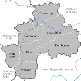
Location of Sange in the district of Olpe |
||
|
Sing in summer
|
||
Sange is a small village in the southern Sauerland with around 70 inhabitants, which belongs to the municipality of Finnentrop in the Olpe district in North Rhine-Westphalia .
The place is located in a protected valley basin at the foot of the Stockhagen mountain (439 m) and south of the highest elevation (508 m). The name Sange points to hill or row graves in Germanic times: buried on the Sangen.
A certain early evidence of the existence of the place Sange results from a document dated December 1, 1326. According to this, a Gobelinus de Sange from Theodericus, miles de Snellenbergh ( Knight of Schnellenberg ) was given an estate in Heggen . Around 1830, Sange consisted of six farms, namely Cordes , Fröhlings , Halleken , Sangermann , Schwarten and Wilmes . Four of these farms were still being managed in the mid-1990s.
Although agriculture is declining and some commercial businesses have settled in Sange, the place has retained its rural character.
Web links
Individual evidence
- ↑ Population statistics of the municipality of Finnentrop (as of December 31, 2016). (PDF) Municipality of Finnentrop, accessed on May 16, 2017 .
- ↑ Archived copy ( Memento of the original from September 21, 2013 in the Internet Archive ) Info: The archive link was inserted automatically and has not yet been checked. Please check the original and archive link according to the instructions and then remove this notice. .: M.Sieg and P.Hesener, The Sanger Höfe and their residents, pp. 160–162


