Santo Toribio District
| Santo Toribio District | |
|---|---|
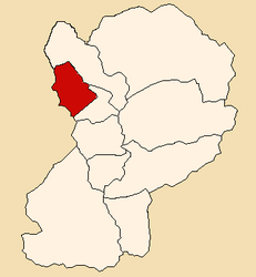
 Location of the Santo Toribio district (marked in red) in the Huaylas province |
|
| Basic data | |
| Country | Peru |
| region | Ancash |
| province | Huaylas |
| Seat | Santo Toribio |
| surface | 84.4 km² |
| Residents | 1136 (2017) |
| density | 13 inhabitants per km² |
| founding | June 19, 1990 |
| ISO 3166-2 | PE-ANC |
| politics | |
| Alcalde District | Álvaro Cairo Pérez Reyes (2019-2022) |
Coordinates: 8 ° 51 ′ 52 " S , 77 ° 54 ′ 53" W
The Santo Toribio district is located in the Huaylas province in the Ancash region of western Peru . The district was established on June 19, 1990. The district was named after Toribio de Mogrovejo , a Spanish missionary and saint.
The district has an area of 84.4 km². The 2017 census counted 1136 inhabitants. In 1993 the population was 2206, in 2007 1403. The district administration is located in the 2860 m high village of Santo Toribio with 283 inhabitants (as of 2017). Santo Toribio is 23 km northwest of the provincial capital Caraz .
Geographical location
The Santo Toribio district is located on the eastern flank of the Cordillera Negra in the northwest of the Huaylas province. The western district boundary runs along the watershed of the Cordillera Negra.
The district of Santo Toribio is bordered to the west by the districts of Caceres del Perú and Macate (both in the province of Santa ), to the north and northeast by the district of Huallanca, and to the east and southeast by the district of Huaylas .
Localities
In addition to the main town, the district has the following localities:
- Huayran
- Iscap
- Nahuinyaco
- Portugal
- Quecuas
- San Lorenzo
- Tambo
- Unión Bellavista
Web links
- Peru: Region Ancash (provinces and districts) at www.citypopulation.de
- INEI Perú