
Schnarrenberg (Stuttgart)
| Schnarrenberg | ||
|---|---|---|
 View from the Aubrücke ( L 1100) leading over the Neckar westwards to the Schnarrenberg
|
||
| height | 315.7 m above sea level NHN | |
| location | in Stuttgart , Baden-Württemberg ( Germany ) | |
| Mountains | Neckar and Tauber-Gäuplatten and Swabian Keuper-Lias-Land | |
| Coordinates | 48 ° 49 ′ 41 ″ N , 9 ° 12 ′ 2 ″ E | |
|
||
| particularities | - Schnarrenberg tunnel - Stuttgart weather office of the German Meteorological Service |
|
 View from Schnarrenberg to Stuttgart- Münster with the Aubrücke ( L 100) leading over the Neckar , the chimney of the Stuttgart-Münster power plant , Schurwald to the left and the Swabian Alb on the horizon to the right |
||

The Schnarrenberg is 315.7 m above sea level. NHN high elevation in the municipalities of Münster and Zuffenhausen in the Baden-Württemberg state capital Stuttgart .
geography
location
The Schnarrenberg lies between the districts of Münster in the southeast, where its main part is, and Zuffenhausen with the district of Rot in the northwest. Its eastern flank slopes down to the Neckar , and to the northwest, its landscape flows over to its tributary Feuerbach . In a south-westerly direction, it leads above the 300 m height line to a 358.8 m high elevation in the Burgholzhof district .
Natural allocation
The Schnarrenberg extends on the border of the natural spatial main unit group Neckar- and Tauber-Gäuplatten (No. 12) with the main unit Neckar basin (123), the subunit Waiblinger Bucht (123.2) and the natural area Marbach-Waiblinger Täler (123.21) in the northeast to the main unit group Swabian Keuper-Lias-Land (10) with the main unit Stuttgarter Bucht (105) and the natural area Feuerbachbucht (105.3) in the southwest. Neighboring natural areas are in the northwest of Long Field (123.14) and the South East Neckar funnel (105.1).
Geology and loess wall
The Schnarrenberg has Keuper -Verwitterungen and from the Quaternary Dating clay - and loess deposits on.
In the lower part of its eastern flank, near the Austraße running along the Neckar, there is an up to 9 m high, almost vertical loess wall with a fine-pored, crystalline structure. Finds of fossils of rare snails and bone fragments of a mammoth were discovered on site. Wall cavities provide breeding and habitat for insects and birds. The almost 12 km long nature trail Geological Stations in Bad Cannstatt and Münster , the 10 stations of which were first provided with information boards in 1990 , leads past the rock face, which is designated as a natural monument . Station 7 is on site: Lösswand Austraße .
Protected areas
On the Schnarrenberg is an area from the eastern part of the landscape protection area vineyard and fruit slopes around the Burgholzhof ( CDDA no. 325728; designated 1961; 1.35 km² in size), with the LSG Neckarlandschaft then directly east of the elevation up to the Zuckerberg Lock at Hofen (CDDA No. 323143; 1961; 1.24 km²) with the Max-Eyth-See there .
Schnarrenberg tunnel
The 272.2 m long Schnarrenberg tunnel of the double-track electrified railway line Stuttgart-Untertürkheim-Kornwestheim ( Schusterbahn ), a freight bypass of the Stuttgart main station , runs through the east shoulder of the Schnarrenberg between Münster and Zazenhausen . It was built in 1895 and its tunnel portals were made from red sand and limestone . Hard-burned bricks were used for the inner lining . Completion was celebrated on December 5, 1895. In the years 1999 to 2000 the tunnel was completely renovated, whereby the inner brickwork was replaced by a concrete shell.
Facilities
The Stuttgart weather office of the German Meteorological Service is located on the summit area of the Schnarrenberg . Sports facilities of the Turnverein Cannstatt with those of the Stuttgart Reds are located on its southwestern highlands , and in the west and north there is a green area with a playground and dog exercise area . On the slopes of the elevation, where there are also allotment gardens , wine is grown on 3.5 hectares with steep partial terraces and south-west orientation. A little east-southeast from the beginning of the road Schnarrenberg (see below ) is a monument Reb land consolidation Stuttgart-Münster - Schnarrenberg - from 1978 to 1980 .
traffic
From the Neckartalstrasse ( Landesstrasse 100; Münster– Hofen ) running east of the Schnarrenberg in the Neckar valley , the Löwentorstrasse, which runs mainly southwest, branches off near the Aubrücke crossing the river . From this, the road axis Am Wolfersberg - Schozacher Straße branches off, which leads northwest to the high elevations of the elevation and then on towards Zuffenhausen. In the transition area to the Burgholzhof, the Am Schnarrenberg cul-de-sac branches off directly northeast of the Robinson Barracks, which leads to the northeast towards its summit .
gallery
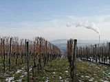
View between the vines of the Schnarrenberg and past the chimney of the Stuttgart-Münster power plant to the Schurwald on the horizon

Schnarrenberg weather station

Schnarrenberg tunnel : south portal


Individual evidence
- ↑ a b Map services of the Federal Agency for Nature Conservation ( information )
- ↑ a b Flyer Geological Stations in Bad Cannstatt and Münster - A journey through geological history , on stuttgart-stadtgeschichte.net (PDF; 1.2 MB)
- ↑ Geological stations - geological history in Stuttgart ( Memento of the original from August 10, 2013 in the Internet Archive ) Info: The archive link was inserted automatically and has not yet been checked. Please check the original and archive link according to the instructions and then remove this notice. , on stuttgart.de
- ↑ Schnarrenberg tunnel on eisenbahnen-der-welt.de