Schwalb (Hornbach)
|
Schwalb Le Schwalbach |
||
|
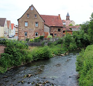
The swallow in Hornbach, Rhineland-Palatinate, Germany |
||
| Data | ||
| Water code | FR : A93-0220 , DE : 2642686 | |
| location | France , the Grand Est region and Germany , on the border between Saarland and France, Rhineland-Palatinate | |
| River system | Rhine | |
| Drain over | Hornbach → Schwarzbach → Blies → Saar → Moselle → Rhine → North Sea | |
| origin | Confluence of two source streams in the municipality of Lemberg (France) 49 ° 0 ′ 51 ″ N , 7 ° 21 ′ 48 ″ E |
|
| Source height | approx. 285 m | |
| muzzle | in Hornbach (Germany) in the Hornbach Coordinates: 49 ° 11 '20 " N , 7 ° 21' 57" E 49 ° 11 '20 " N , 7 ° 21' 57" E |
|
| Mouth height | approx. 240 m above sea level NHN | |
| Height difference | approx. 45 m | |
| Bottom slope | approx. 1.6 ‰ | |
| length | approx. 28 km | |
| Catchment area | 114.47 km² | |
| Medium-sized cities | Blieskastel | |
| Small towns | Hornbach | |
| Communities | Lemberg , Lambach , Siersthal , Hottviller , Volmunster | |
The Schwalb (French: La Schwalb or Le Schwalbach ) is an approximately 28 km long tributary to the left of the Hornbach . With its tributaries, the swallow drains central parts of the Pays de Bitche , the Bitscher Land . 23.4 km of the entire course of the Schwalb are on French territory.
geography
course
The Schwalb rises from three source ditches on the northern and western outskirts of Lemberg . The eastern outflows, however, result in the Moderbach , which flows over the northern Zinsel to the Moder , which flows into the Rhine . Thus there is a watershed between the Rhine and the Moselle .
The Schwalb takes all their way fairly straight north, first on the Loechersbacherweiher at Lambach and Siersthal past when from the right Pregnant Bach added. It continues over the Froehmuehle to Holbach . After that the valley is less populated and there are only a few villages, but many mills. After the D 620 has crossed the stream, it flows via Weiskirch to the canton capital Volmunster , where the only still active grain mill is located. From the Loutzviller mill, the stream forms the state border with Germany , first to the Saarland and then from the Moulin de Schweyen to just before Hornbach to Rhineland-Palatinate . In the urban area of Hornbach the Schwalb joins the Hornbach from the left.
Tributaries
- Schwangerbach ( right ), 7.4 km
- Steschbach ( left ), 3.2 km
- Ruisseau du Grossthal ( right ), 1.5 miles
- Bitscherbach ( Ruisseau de Bitche ) ( right ), 2.0 km
- Korbach ( right ), 1.2 km
- Bierbach ( left ), 3.8 km
- Dorfbach ( left ), 3.0 km
- Baechelbach ( Ruisseau Backelbach ) ( right ), 2.3 km
- Weisskircherbach ( left ) 3.0 km
- Bachelbach ( left ), 2.1 km
- Nesselbach ( right ), 3.0 km
- Bach from Teufelsberg ( right ), 2.0 km, 2.08 km²
- Becherbach ( left ), 1.2 km, 2.15 km²
- Ringweiler Talbach ( left ), 1.9 km, 2.52 km²
Traffic routes
From Volmunster to Hornbach , the Sentier des Moulins ( Mühlenwanderweg ) runs parallel to the Schwalb. The European Mill Cycle Path also uses the Schwalbtal on this section, where the Moulin d'Eschviller is a worth seeing mill museum. From 1916 to 1945 the Hornbachbahn also ran along the Schwalb between Hornbach and Brenschelbach .
See also
Web links
- Le Schwalbach near SANDRE (French)
- Débits caractéristiques du Schwalbach (French; PDF; 12 kB)
Individual evidence
- ↑ a b Water information system Service d'Administration National des Données et Référentiels sur l'Eau (French) ( information )
- ↑ a b GeoExplorer of the Rhineland-Palatinate Water Management Authority ( information )
- ↑ a b c In-house measurement on the Géoportail map service ( notes )

