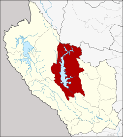
Si Sawat district
|
Si Sawat ศรีสวัสดิ์ |
|
|---|---|
| Province: | Kanchanaburi |
| Surface: | 3,295.9 km² |
| Residents: | 25,278 (2013) |
| Population density : | 7 U / km² |
| ZIP : | 71250, 71220 |
| Geocode : | 7104 |
| map | |

|
|
Amphoe Si Sawat ( Thai อำเภอ ศรีสวัสดิ์ ) is a district ( amphoe - administrative district) in Kanchanaburi Province . Kanchanaburi Province is located in the western part of the central region of Thailand . The district capital is located about 180 km northwest of Bangkok .
geography
The neighboring counties are (clockwise from north): Amphoe Ban Rai in Uthai Thani Province , Amphoe Dan Chang in Suphan Buri Province, and Amphoe Nong Prue , Bo Phloi , Mueang Kanchanaburi , Sai Yok and Thong Pha Phum in Kanchanaburi Province.
history
The area was already inhabited thousands of years ago, as shown by excavations in the Tham Ongbah cave .
Attractions
landscape
The district is dominated by the Si-Nakharin reservoir. Part of the reservoir belongs to the Khuean Srinakarin National Park. The 140-meter-high Si Nakharin Dam was completed in 1980. It dams the Mae Nam Khwae Yai (Khwae Yai River) to a 419 km² lake. The dam has received much criticism because it was built on the Si Sawat fault zone .
National parks
The following national parks are located in Amphoe Si Sawat:
- The Erawan National Park ( อุทยานแห่งชาติ เอราวัณ ) with the famous Erawan Waterfall, which falls in seven cascades from a height of 1200 meters, is located in the south of the district.
- The Khuean Si Nakharin National Park ( อุทยานแห่งชาติ เขื่อน ศรีนครินทร์ ), founded in 1981, has a size of 1532 km². Numerous waterfalls, hot springs and caves are worth seeing.
administration
Provincial Administration
Si Sawat County is divided into six tambon ("subdistricts" or "municipalities"), which are further subdivided into 34 muban ("villages").
| No. | Surname | Thai | Muban | Pop. |
|---|---|---|---|---|
| 1. | Well Suan | นาสวน | 5 | 4,314 |
| 2. | Dan Mae Chalaep | ด่าน แม่ แฉลบ | 8th | 4,858 |
| 3. | Nong Pet | หนอง เป็ด | 4th | 2,524 |
| 4th | Tha Kradan | ท่า กระดาน | 6th | 5,924 |
| 5. | Khao Chot | เขา โจ ด | 5 | 4.033 |
| 6th | Mae Krabung | แม่ กระบุง | 6th | 3,625 |
Local administration
There are two municipalities with "small town" status ( Thesaban Tambon ) in the district:
- Khao Chot (Thai: เทศบาล ตำบล เขา โจ ด ) consisting of the complete Tambon Khao Chot.
- Erawan (Thai: เทศบาล ตำบล เอราวัณ ) consisting of parts of the Tambon Tha Kradan.
There are also five " tambon administration organizations " ( องค์การ บริหาร ส่วน ตำบล - Tambon Administrative Organizations, TAO)
- Na Suan (Thai: องค์การ บริหาร ส่วน ตำบล นาสวน ) consisting of the complete Tambon Na Suan.
- Dan Mae Chalaep (Thai: องค์การ บริหารส่วน ตำบล ด่าน แม่ แฉลบ ) consisting of the complete tambon Dan Mae Chalaep.
- Nong Pet (Thai: องค์การ บริหาร ส่วน ตำบล หนอง เป็ด ) consisting of the complete Tambon Nong Pet.
- Tha Kradan (Thai: องค์การ บริหาร ส่วน ตำบล ท่า กระดาน ) consisting of parts of the Tambon Tha Kradan.
- Mae Krabung (Thai: องค์การ บริหารส่วน ตำบล แม่ กระบุง ) consisting of the complete tambon Mae Krabung.
Individual evidence
- ↑ Thailand's Nam Choan Dam Project: A Case Study in the 'Greening' of South-East Asia : Article from the "Global Ecology and Biogeography Letters", Vol. 1, No. 2 (Mar., 1991), pp. 42-54
- ↑ Information on the Khuean-Si-Nakharin National Park ( Memento of the original from May 22, 2013 in the Internet Archive ) Info: The archive link has been inserted automatically and has not yet been checked. Please check the original and archive link according to the instructions and then remove this notice. (in English)
- ↑ 2013 population statistics ( Thai ) Department of Provincial Administration. Retrieved September 10, 2014.
Web links
- More information on Amphoe Si Sawat from amphoe.com (in Thai; last accessed December 1, 2015)
Coordinates: 14 ° 36 ' N , 99 ° 7' E


