
Sieve (river)
| Sieve | ||
 Location of Sieve |
||
| Data | ||
| location | Metropolitan city of Florence , Tuscany , Italy | |
| River system | Arno | |
| Drain over | Arno → Tyrrhenian Sea | |
| River basin district | Appennino Settentrionale | |
| source | near the Futa Pass in Mugello near Barberino di Mugello | |
| Source height | 930 m slm | |
| muzzle | near Pontassieve in the Arno Coordinates: 43 ° 46 ′ 14 " N , 11 ° 26 ′ 28" E 43 ° 46 ′ 14 " N , 11 ° 26 ′ 28" E
|
|
| length | 60 km | |
| Left tributaries | San Godenzo , Moscia | |
| Right tributaries | Carza | |
| Communities | Barberino di Mugello , San Piero a Sieve , Borgo San Lorenzo , Vicchio , Dicomano , San Godenzo , Rufina , Pontassieve | |
 The Sieve at San Piero a Sieve (municipality of Scarperia e San Piero ) |
||
The Sieve is a river in the Italian region of Tuscany that crosses the metropolitan city of Florence from north to south.
course
It rises at an altitude of 930 m above sea level in the Apennines near the southern part of the Futa Pass in Mugello near Barberino di Mugello (13 km in the municipality) and continues to flow to the municipality of Scarperia e San Piero (district of San Piero a Sieve , 5 km in the municipality), where the Carza flows in from the right near the center of San Piero a Sieve, and to Borgo San Lorenzo (7 km in the municipality) and Vicchio (12 km in the municipality). It then passes Dicomano (6 km in the municipality), where it is fed by the Comano and San Godenzo rivers (coming from San Godenzo ) and then reaches Rufina (7 km in the municipality) and Pelago (2 km in the municipality). It flows through Tuscany for a length of 60 km before it flows into the Arno at Pontassieve (6 km in the municipality) .
photos

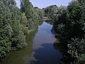
The Sieve at Pontassieve

The Sieve at Pontassieve
The Sieve at San Piero a Sieve (municipality of Scarperia e San Piero)


literature
- Giorgio Battini: Il fiume racconta. Viaggio nella Toscana dei fiumi. , Bonechi, Florenz 1993, ISBN 88-7009-941-5 , p. 39 ff.
- Emanuele Repetti: SIEVE fiumana. In Dizionario Geografico Fisico Storico della Toscana (1833–1846), online edition of the University of Siena (pdf, Italian, p. 2.)
- Sieve . In: Meyers Konversations-Lexikon . 4th edition. Volume 14, Verlag des Bibliographisches Institut, Leipzig / Vienna 1885–1892, p. 960.