
Solar eclipse of April 21, 2088
| Solar eclipse of April 21, 2088 | |
|---|---|

|
|
| classification | |
| Type | Total |
| area | Eastern America , Atlantic , Northern Africa , Europe , Western Asia Total: Cape Verde , Western Sahara , Mauritania , Mali , Algeria , Tunisia , Italy , Malta , Greece , Turkey , Georgia , Russia , Kazakhstan , Uzbekistan , Kyrgyzstan , People's Republic of China |
| Saros cycle | 130 (56 of 73) |
| Gamma value | 0.4134 |
| Greatest eclipse | |
| Duration | 3 minutes 58 seconds |
| place | Mediterranean Sea near Malta |
| location | 36 ° 0 ′ N , 15 ° 6 ′ E |
| time | April 21, 2088 10:28:53 UT |
| size | 1.0474 |

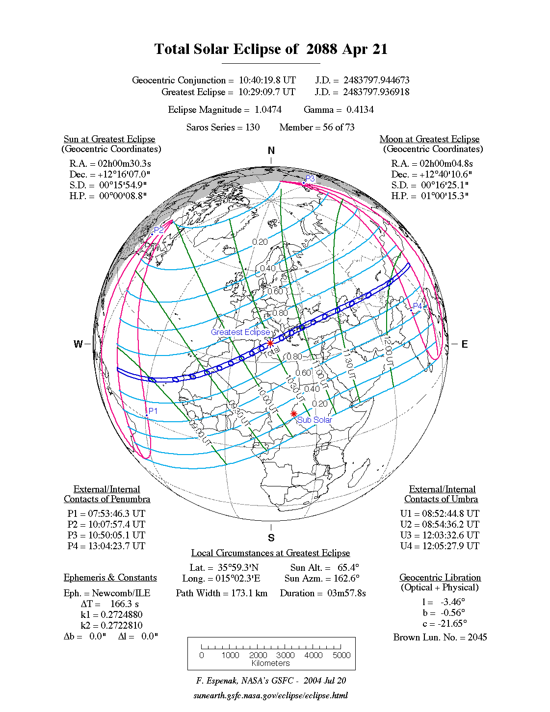
The total solar eclipse of April 21, 2088 takes place largely over the Atlantic Ocean , North Africa , Southeast Europe , Asia Minor and Northern Asia . In the far east of America , the solar eclipse can be observed in its partial phase at sunrise.
The maximum of the eclipse is in the Mediterranean about 50 km northeast of Malta , the duration of the totality there is 3 minutes and 58 seconds.
course
The eclipse begins over the Atlantic off the coast of South America . In the east of South America the eclipse can be partially observed, whereby it begins before sunrise and, with the exception of the extreme west of Brazil , the maximum was reached before sunrise. In the extreme northeast of America, the eclipse does not begin until after sunrise, but only reaches a low level of coverage. The moon's shadow quickly crosses the Atlantic in a northeastern direction, crosses the Cape Verde Islands and meets the African mainland for the first time on the Atlantic coast of Mauritania . The moon's shadow then crosses the countries of Western Sahara , Mali , Algeria and Tunisia . After the shadow leaves Africa, it crosses the Mediterranean. The Italian islands of Lampedusa and Sicily are in the totality zone, as is the island state of Malta . With Greece the moon shadow now also reaches the European mainland, after crossing the northern Aegean Sea the moon shadow reaches Asia. Here the eclipse zone runs through the states of Turkey , Georgia , Russia , Kazakhstan , Uzbekistan , Kyrgyzstan and the People's Republic of China , where the eclipse ends at sunset.
For this eclipse there are clear local differences in the calculation of the concrete course of the totality zone due to the significantly different assumptions of the Delta T (NASA: 175.4s, Calsky: 76.8s) of 98.6s. According to NASA calculations, the city center of the Kyrgyz capital Bishkek lies within the totality zone, while Calsky sees it outside.
Places in the totality zone
| country | place | Duration | Time ( UT ) | comment |
|---|---|---|---|---|
| Cape Verde | Santa Maria | 2m 12s | 9:05 | Duration in the north of the island of Sal up to 2m 26s |
| Algeria | Adrar | 3m 13s | 9:47 | |
| Tunisia | There was | 3m 52s | 10:16 | |
| Italy | Lampedusa | 3m 57s | 10:23 | |
| Malta | Valletta | 3m 57s | 10:28 | |
| Greece | Patras | 3m 45s | 10:45 | |
| Turkey | Istanbul | 3m 15s | 11:01 am | |
| Georgia | Zugdidi | 3m 3s | 11:24 | |
| Russia | Vladikavkaz | 3m 18s | 11:28 | |
| Russia | Makhachkala | 2m 49s | 11:29 | |
| Kazakhstan | Aqtau | 3m 1s | 11:36 | |
| Uzbekistan | Qoʻngʻirot | 2m 18s | 11:45 | |
| Kazakhstan | Schymkent | 1m 47s | 11:55 | |
| Kyrgyzstan | Valley | 2m 23s | 11:56 | |
| Kyrgyzstan | Bishkek | 0m 32s | 11:57 | According to Calsky outside the totality zone |
| China | Aksu | 1m 55s | 12:01 pm |
Visibility in German-speaking countries
The eclipse is visible in the German-speaking area, as a partial solar eclipse, throughout the course. The greatest eclipse is achieved in the southeast, in Bad Radkersburg in the Austrian state of Styria , with 70% coverage. The lowest eclipse is achieved in the north, in List on Sylt , with 40% coverage.
| country | place | cover | comment |
|---|---|---|---|
| Switzerland | Bern | 60% | |
| Switzerland | Basel | 58% | |
| Austria | Salzburg | 63.6% | |
| Austria | Vienna | 65.8% | |
| Germany | Munich | 61% | |
| Germany | Frankfurt am Main | 52% | |
| Germany | Berlin | 50% | |
| Germany | Hamburg | 45% |
Individual evidence
- ↑ NASA: Besselian Elements for the Total Solar Eclipse of 2088 Apr 21
- ↑ CalSky: Local course of the solar eclipse - Wednesday, April 21, 2088 (possibly select location and click on solar eclipse )
- ↑ a b c The duration of the totality, the time of the middle of the totality were determined with the interactive map of NASA ( Total Solar Eclipse of 2088 Apr 21, Google Maps and Solar Eclipse Paths )
- ^ Calsky, map of the solar eclipse of April 21, 2088
Web links
- NASA: Total Solar Eclipse of 2088 Apr 21
- NASA: Google Maps and Solar Eclipse Paths: 2081–2100
- NASA: Solar Eclipses of Saros 130
|
Previous solar eclipses:
|
Later solar eclipses:
|
|||||||||
| June 11, 2086 (total) |
December 6, 2086 (partial) |
May 2, 2087 (partial) |
June 1, 2087 (partial) |
October 26, 2087 (partial) |
April 21, 2088 (total) |
October 14, 2088 (ring-shaped) |
April 10, 2089 (ring-shaped) |
4 October 2089 (total) |
March 31, 2090 (partial) |
23 September 2090 (total) |
|
|
|
|
|
|
|
|
|
|
|
|
| Lists: 20th century • 21st century • All lists | ||||||||||