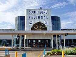
South Bend Airport
| South Bend International Airport | |
|---|---|

|
|
| Characteristics | |
| ICAO code | KSBN |
| IATA code | SBN |
| Coordinates | |
| Height above MSL | 244 m (801 ft ) |
| Transport links | |
| Distance from the city center | 6 km northwest of South Bend |
| Street | US 20 / US 20 bus / US 31 |
| Local transport |
Bus : Transpo Route 4 Train : NICTD South Shore Line |
| Basic data | |
| opening | 1933 |
| operator | St. Joseph County Airport Authority |
| surface | 890 ha |
| Terminals | 1 |
| Passengers | 610,818 (2017) |
| Air freight | 10,411 t (2018) |
| Flight movements |
40,100 (2018) |
| Employees | 60 |
| Runways | |
| 09L / 27R | 1311 m × 23 m asphalt |
| 09R / 27L | 2565 m × 46 m asphalt |
| 18/36 | 2164 m × 46 m asphalt |
The South Bend International Airport ( IATA : SBN , ICAO : KSBN ) is a regional airport near the city of South Bend in the US state of Indiana . Previous names are Bendix Field, St. Joseph County Airport, and Michiana Regional Transportation Center and South Bend Regional Airport .
Location and transport links
South Bend International Airport is located six kilometers northwest of downtown South Bend. It is located on US Highway 20 Business , which runs south of the airport. This crosses US Highway 31 west of the airport and returns to the regular US Highway 20 .
South Bend International Airport is accessible by bus and train . The route 4 of the bus operator Transpo connects it regularly with the city center. Trains also run on the South Shore Line operated by Northern Indiana Commuter Transportation District between the airport and Millennium Station in Chicago .
Airlines and Destinations
South Bend International Airport is used by Allegiant Air , American Eagle , Delta Air Lines / Delta Connection and United Express . There are twelve destinations exclusively located in the United States , including mainly the hubs of the individual airlines.
Traffic figures

| year | Passenger volume | Air freight ( tons ) (with airmail) |
Aircraft movements (with military) |
|---|---|---|---|
| 2018 | 10,411 | 40,100 | |
| 2017 | 610.818 | 10,779 | 38,308 |
| 2016 | 658.076 | 11,184 | 38,255 |
| 2015 | 623.903 | 12,572 | 34,913 |
| 2014 | 602.255 | 12.208 | 33.503 |
| 2013 | 629.287 | 11,550 | 33.122 |
| 2012 | 589.030 | 11,659 | 33,833 |
| 2011 | 599.127 | 10,868 | 33,420 |
| 2010 | 626.597 | 10,752 | 33,495 |
| 2009 | 625.077 | 9,619 | 37,028 |
| 2008 | 704.418 | 16,098 | 43,650 |
| 2007 | 779.359 | 18,632 | 48,323 |
| 2006 | 729.619 | 18,693 | 56,862 |
| 2005 | 693,675 | 16.091 | 64,255 |
| 2004 | 780.033 | 14,243 | 62,343 |
| 2003 | 802.191 | 13,683 | 65,100 |
| 2002 | 812.080 | 12.096 | 74,998 |
| 2001 | 739.407 | 11.008 | 74,132 |
| 2000 | 856.876 | 13,375 | 73,439 |
| 1999 | 955.232 | 14,800 | 82,416 |
| 1998 | 986.350 | 13,881 | 82,406 |
Busiest routes
| rank | city | Passengers | airline |
|---|---|---|---|
| 1 | Atlanta , Georgia | 63,290 | Delta / Delta Connection |
| 2 | Detroit , Michigan | 60,690 | Delta Connection |
| 3 | Chicago-O'Hare , Illinois | 57,410 | United Express |
| 4th | Minneapolis-Saint Paul , Minnesota | 28,130 | Delta Connection |
| 5 | Punta Gorda , Florida | 24,790 | Allegiant |
| 6th | Orlando – Sanford , Florida | 23,090 | Allegiant |
| 7th | Charlotte , North Carolina | 19,300 | American Eagle |
| 8th | St. Petersburg , Florida | 19,250 | Allegiant |
| 9 | Dallas / Fort Worth , Texas | 18,800 | American Eagle |
| 10 | Phoenix-Mesa , Arizona | 15,850 | Allegiant |
Web links
- Official website (English)
Individual evidence
- ^ History. FlySBN.com, accessed April 8, 2017 .
- ↑ AirportIQ 5010: South Bend International. GCR1.com, accessed November 28, 2017 .
- ↑ a b c North America Airport Rankings. ACI-NA.org , accessed on March 28, 2019 .
- ↑ a b c Media & Statistics. FlySBN.com, accessed March 28, 2019 .
- ↑ Routes & Fares. SBTranspo.com , accessed on March 29, 2019 (English).
- ↑ Taxi, Train, Bus & Ridesharing. FlySBN.com, accessed March 29, 2019 .
- ↑ a b Airlines. FlySBN.com, accessed March 29, 2019 .
- ^ South Bend, IN: South Bend International (SBN). Transtats.BTS.gov , accessed March 28, 2019 .
