South Fork Township (Jackson County, Iowa)
| South Fork Township | ||
|---|---|---|
|
Location in Iowa
|
||
| Basic data | ||
| Foundation : | 1845 | |
| State : | United States | |
| State : | Iowa | |
| County : | Jackson County | |
| Coordinates : | 42 ° 5 ′ N , 90 ° 44 ′ W | |
| Time zone : | Central ( UTC − 6 / −5 ) | |
| Residents : | 4,647 (as of 2010) | |
| Population density : | 49.9 inhabitants per km 2 | |
| Area : | 93.2 km 2 (approx. 36 mi 2 ) | |
| Height : | 269 m | |
| Postal code : | 52060 | |
| Area code : | +1 563 | |
| FIPS : | 19-93948 | |
| GNIS ID : | 468729 | |
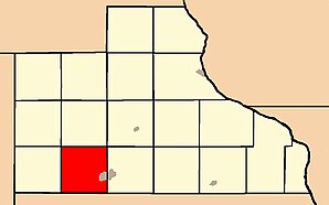
 Location of South Fork Township in Jackson County |
||
The South Fork Township is one of 18 townships in Jackson County in the eastern part of the US -amerikanischen state of Iowa .
geography
The South Fork Township is located in eastern Iowa about 45 km west of the Mississippi , which forms the border with Illinois . The Wisconsin border is around 50 km north.
The South Fork Township lies at 42 ° 05'25 "north latitude and 90 ° 43'38" west longitude and extends over 93.2 km².
The township is traversed in a west-east direction by the main or southern arm (English: South Fork ) of the Maquoketa River , a tributary of the Mississippi. The northern arm of the river flows into the far east of the township.
The South Fork Township is located in the southwest of Jackson County and borders on Clinton County to the south . Within Jackson County, South Fork Township is bordered by Monmouth Township to the west, Brandon Township to the northwest , Farmers Creek Township to the north, Perry Township to the northeast and Maquoketa Township to the east .
Protected areas
The following protected and recreational areas exist in the South Fork Township:
- Maquoketa Caves State Park
- Black Hawk Wildlife Area
traffic
In north-south direction, US Highway 61 runs through the township and forms the western bypass of the city of Maquoketa . This is where Iowa Highway 64, which runs in a west-east direction, crosses . All other roads are either county roads or further subordinate and partly unpaved roads.
The Maquoketa Municipal Airport is located south of Township; the nearest major airport is Quad City International Airport, around 80 km south .
population
At the 2010 census , the township had 4,647 inhabitants. In addition to scattered settlements, there are two settlements in the South Fork Township:
- Maquoketa 1 ( City )
- Hurstville ( Unincorporated Community )
1 - partly in Maquoketa Township
Buckhorn
Buckhorn is a ghost town on Iowa Highway 64 about one kilometer northwest of the airport. It was founded as a farmer's cooperative in the early 20th century and was given up in 1962 after it was taken over by a large dairy. What was left was a cemetery, an abandoned church and the old dairy building.
Individual evidence
- ↑ Distance information according to Google Maps. Accessed June 7, 2012
- ↑ Census Data Center - Iowa ( page no longer available , search in web archives ) Info: The link was automatically marked as defective. Please check the link according to the instructions and then remove this notice. Retrieved June 7, 2012
- ↑ 10 Abandoned ghost towns in Iowa at www.thevintagenews.com, accessed January 7, 2017
