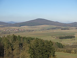
Stallberg (mountain)
| Stallberg | ||
|---|---|---|
|
Stallberg from the southwest, taken from the Via Regia observation tower on the Rößberg near Großenbach |
||
| height | 552.9 m above sea level NHN | |
| location | near Hünfeld - Kirchhasel ; District of Fulda , Hessen ( Germany ) | |
| Mountains | Soisberger Kuppenrhön , Rhön | |
| Coordinates | 50 ° 43 '2 " N , 9 ° 50' 31" E | |
|
|
||
| Type | Kegelberg | |
| rock | basalt | |
| Age of the rock | Tertiary | |
| particularities | Barrows and ramparts | |
The Stallberg in the Hessian district of Fulda is 552.9 m above sea level. NHN high mountain of Soisberger Kuppenrhön , part of the German low mountain range Rhön . Barrows and a ring wall lie on top of it .
geography
location
The Stallberg rises as part of the Hessian bowling game in the Hessian Rhön Nature Park and in the Rhön Biosphere Reserve . Its summit is 7.3 km northeast of Hünfeld , in the district of Kirchhasel , 3.4 km south-west of the summit , and 3.9 km (as the crow flies ) west of the center of the municipality of Rasdorf . Around the mountain, some of them a little further away, are the villages of Großentaft in the north-northeast, Haselstein in the south-south-east and Neuwirtshaus in the south-west and Stendorf in the west-north-west.
Natural allocation
The Stallberg belongs to the natural spatial main unit group Osthessisches Bergland (No. 35), in the main unit Vorder- und Kuppenrhön (353) and in the subunit Kuppenrhön (353.2) to the natural area Soisberger Kuppenrhön (353.22).
geology
The Stallberg was created by the Rhön volcanism in the Tertiary . Here, the layers of red sandstone and the shell limestone layers on top of them were lifted by magma rising from the subsoil and finally penetrated, so that basaltic lava flowed out. However, the mountain only represents the chimney filling of the volcano that has remained after extensive erosion . Extensive block heaps , which have their origin in the physical weathering of the basalt, can be found on all slopes of the summit.
Barrows and ramparts
On the Stallberg there are barrows from the Bronze Age barrows as well as a ring wall , which is dated earlier to the Iron Age according to more recent finds (bronze knife with handle spike and over 260 ceramic finds) and investigations from 2017 into the urn field culture (Ha A2), which was used as a refuge for the population at the time - or the place of settlement. The approximately 900 meter long and 6 hectare ring wall is slightly oval (west-east), whereby the western stone wall is still best preserved. The first investigations by Joseph Vonderau took place here in 1903 , who examined the wall in one section. The wooden structures he discovered ( Murus Gallicus technique ) could not be confirmed in the more recent studies carried out in 2017 by a team led by Professor Rüdiger Krause from the Institute for Archaeological Sciences at Goethe University Frankfurt . The new finds allow dating to the Bronze Age . C14 pollen analyzes are still pending in order to enable a possible more precise dating.
A similar, presumably slightly younger, Celtic ring wall system is only a few kilometers away on the Kleinberg : the ring wall system Kleinberg .
Protected areas
The Stallberg nature reserve near Hünfeld ( CDDA no. 82616; designated in 1973; 1.75 km² in size) lies on large parts of the Stallberg and extends to its summit region. On the mountain there are also parts of the Hessian Rhön landscape protection area (CDDA no. 378477; 1967; 410.31 km²), the fauna-flora-habitat area Vorderrhön (FFH no. 5325-305; 36.9 km²) and of the bird sanctuary Hessische Rhön (VSG no. 5425-401; 360.8 km²).
Flora and fauna
The soils of the Stallberg are rich in nutrients and support demanding deciduous forest communities. Since 1977 there has been no forestry use due to nature conservation. Pine marten , badger , small woodpecker , mountain newt and common frog were found on the Stallberg by the red list of endangered species .
Traffic and walking
The federal highway 84 , which connects Rasdorf with Hünfeld , runs southeast past the Stallberg in a north-east-south-west direction . From this the district road 132 branches off , which leads northeast through Kirchhasel to Stendorf and ends there near the mountain. In addition, the state road 3173 branches off from the B 84 , which runs east of the mountain in a northward direction to Großentaft .
The wooded mountain is accessible to tourists from the Kegelspielweg (HWO 1), the Extra Tour Kegelspiel and the Stallbergweg , all of which are hiking trails of the Rhön Club .
Web links
- Stallberg, District of Fulda. Historical local lexicon for Hesse (as of February 11, 2014). In: Landesgeschichtliches Informationssystem Hessen (LAGIS). Hessian State Office for Historical Cultural Studies (HLGL), accessed on January 1, 2015 .
Individual evidence
- ↑ a b c Map services of the Federal Agency for Nature Conservation ( information )
- ↑ Rüdiger Krause: The Stallberg near Hünfeld - a Bronze Age hilltop castle with fortifications , lecture at the Hesse ARCHAEOLOGY Day 2017 on November 11, 2017
- ^ Rolf Gensen: The Iron Age ring walls on the Stallberg and the Kleinberg. Leaflet on the fortifications at Hünfeld-Kirchhasel and at Rasdorf in the Fulda district (1985) , Archäologische Denkmäler in Hessen (issue 49), Wiesbaden 1985, ISBN 3-89822-049-4 .
- ^ "Stallberg" nature reserve - core zone of the Rhön Biosphere Reserve , accessed on October 13, 2012, at biosphaerenreservat-rhoen.de
- ^ Rhönklub: Hiking , accessed on October 13, 2012, on rhoenklub.de

