
Stockhausen (Windhagen)
|
Stockhausen
Local community Windhagen
Coordinates: 50 ° 39 ′ 29 ″ N , 7 ° 21 ′ 34 ″ E
|
||
|---|---|---|
| Height : | 295 m above sea level NHN | |
| Residents : | 515 (May 25 1987) | |
| Postal code : | 53578 | |
| Area code : | 02683 | |
Location of Stockhausen in Rhineland-Palatinate |
||

Stockhausen is a district of the local community Windhagen in the district of Neuwied in Rhineland-Palatinate with over 500 inhabitants.
geography
Stockhausen is located on the Asbach plateau in the northwestern Westerwald at altitudes between 265 and 300 m above sea level. NHN and is directly adjacent to the Aegidienberger Forest, which extends to the west . There the terrain rises to the Dachsberg ( 362 m above sea level ), to the east it falls to the Stockhausener Bach and its nearby tributary Forthbach . Stockhausen does not have a traditional town center, but extends along Dorfstrasse. The closest localities include Germscheid , 1.5 kilometers to the northeast , and Wülscheid, 1.5 kilometers to the northwest .
history
Stockhausen was documented in 1418 as a service mansion of the Electoral Cologne office of Altenwied . The yard was probably due originally from Dassel originating Junker founded by Stockhausen and when Motte been expanded. Around 1550 it fell into the possession of "von Neustadt, called Munt", and in 1600 it became a knight seat of the Counts of Nesselrode . In 1660, Stockhausen recorded ten houses as part of the Windhagen community in the parish of the same name during an inventory in the Altenwied office.
In Prussian times (from 1815) Stockhausen remained part of the Honschaft, later the municipality of Windhagen, since 1823 in the administrative district of the Asbach mayor . As part of censuses in the first half of the 19th century, Stockhausen was initially a hamlet , in 1843 it was recorded as a village and comprised 35 residential and 25 farm buildings. The knight seat of the Counts of Nesselrode was abandoned in 1830, but was preserved as a building.
In 1907 Stockhausen received a telegraph auxiliary post and in 1931 its own class II post office in the district of the Asbach post office. In 1932, a memorial was erected on Stockhausener Strasse to commemorate those who fell in the First World War. At the end of the 1930s, the south-west camp of the then operational (air) port of Eudenbach was built north of Stockhausen on the Mußer Heide (also Musser Heide ). It was laid down after the Second World War. In 1959, the Stockhausen post office was assigned to the Linz post office and, as a late consequence of the municipal reorganization, was converted into a receiving post office in 1980.
The dialect name of the place is "Stockes".
- Population development
| year | Residents |
|---|---|
| 1816 | 148 |
| 1828 | 196 |
| 1843 | 190 |
| 1885 | 191 |
| 1987 | 515 |
Wies cookies
The present-day desert of Wiesplätze , halfway between Stockhausen and Germscheid , also belonged to the Stockhausen court and later knight's seat . One of the farms of this place mentioned earlier was the Blietzgenhöffgen . After being destroyed in the Thirty Years' War , Wiesplätze was rebuilt and counted three houses in the 1660 inventory in the Altenwied office. The place never grew beyond this extent. The annual lease of the farm was 11 Malter oats . The spelling of the place name developed over Weisplätzgen (1729), Wiespletzgen (1765), Wiesenplaetz (1803-1820) and Wiesplätzgen (19th century) to Wiesplätze .
In 1829 there were still two (of originally three) residential buildings in Wiesplätze, one of which had previously fallen victim to a fire. In the 1843 census , Wiesplätze was recorded as a farm and comprised a residential and two farm buildings with eight residents. In 1905 the population had dropped to five. After the last residential building at that time burned down in autumn 1929, Wiesplätze became a desert.
Attractions
A major attraction of Stockhausen is the neo-Gothic Marienkapelle , a brick hall built from 1884 to 1886. As a cultural monument under monument protection is also a half-timbered house of the former farm of Count Nesselrode , which was built in the core before 1700s. In Weiherstraße there is a protected crossroads from 1876, on the Ringstraße there is an oak that has been designated as a natural monument .
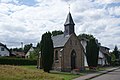
Chapel in Stockhausen

Memorial of honor


Web links
Individual evidence
- ^ A b State Statistical Office Rhineland-Palatinate - Official directory of the municipalities and parts of the municipality
- ^ Heinrich Neu, Hans Weigert: Die Kunstdenkmäler des Kreis Neuwied ( Die Kunstdenkmäler der Rheinprovinz, Volume 16, Section II), Düsseldorf, Schwann, 1940, pages 393/394
- ^ Ernst-Dieter Meyer: The knight seat Stockhausen. In: Windhagen - Ein Heimatbuch , Economica Verlag, Bonn 1994, pp. 51–56
- ↑ August Welker: Inventory in the Altenwied office anno 1660. In: Heimat-Jahrbuch des Landkreis Neuwied , 1977, pp. 101-103.
- ^ AA Mützell: New topographical-statistical-geographical dictionary of the Prussian state , Verlag KA Kümmel, Halle 1823, fourth volume, p. 386
- ^ Community encyclopedia for the Kingdom of Prussia (PDF; 1.4 MB), Volume XII Provinz Rheinland, Verlag des Königlich Statistischen Bureaus (publisher), 1888, page 44
- ↑ a b Theo Winterscheid: From the history of the post in the Windhagener area. In: Windhagen - Ein Heimatbuch , Economica Verlag, Bonn 1994, pp. 116–119.
- ^ Karl-Heinz Prangenberg: The monument to fallen in Stockhausen . In: Heimatblatt Altenwied 2008/2009 , pp. 65–71.
- ↑ Helmut Wolff: The Windhagen dialect. In: Windhagen - Ein Heimatbuch , Economica Verlag, Bonn 1994, p. 196.
- ^ The government district of Coblenz according to its location, limitation, size, population and division ... , Coblenz: Pauli, 1817; Page 89
- ↑ Friedrich von Restorff : Topographical-Statistical Description of the Royal Prussian Rhine Province , Nicolaische Buchhandlung, Berlin and Stettin 1830, p. 693
- ↑ a b Topographical-statistical overview of the government district of Coblenz , Coblenz: Hölscher, 1843, page 66
- ^ Community encyclopedia for the Kingdom of Prussia , Volume XII Province Rhineland, Verlag des Königlich Statistischen Bureaus (Ed.), 1888, pp. 44 u. 45
- ^ Anton Stockhausen: Lost settlements and courtyards. In: Windhagen - Ein Heimatbuch , Economica Verlag, Bonn 1994, pp. 62–64.
- ^ General Directorate for Cultural Heritage Rhineland-Palatinate (ed.): Informational directory of cultural monuments - Neuwied district. Mainz 2019, p. 71 (PDF; 6.4 MB).
- ↑ Landscape information system of the nature conservation administration ( memento of the original from March 6, 2016 in the Internet Archive ) Info: The archive link was inserted automatically and has not yet been checked. Please check the original and archive link according to the instructions and then remove this notice.
Birch trees | Happy | Günterscheid | Hallerbach | Scorn | Hüngsberg | Johannisberg | Köhlershohn | Rederscheid | Tail field | Stockhausen | Windhagen