Stralauer Platz
| Stralauer Platz | |
|---|---|
| Place in Berlin | |
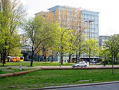
 View across the square to the DB service building next to the Ostbahnhof |
|
| Basic data | |
| place | Berlin |
| District | Friedrichshain |
| Created | 18th century |
| Newly designed | 20th century |
| Confluent streets |
At the Schillingbrücke, Holzmarktstrasse, Andreasstrasse, Koppenstrasse, Am Ostbahnhof, Strasse der Pariser Kommune , Mühlenstrasse |
| Buildings | see: History of development |
| use | |
| User groups | Road traffic , pedestrians , stationary traffic |
| Technical specifications | |
| Square area | 67,000 m² |
The Stralauer Platz is a historically grown town square in Berlin Friedrichshain-Kreuzberg between Ostbahnhof and the north bank of the Spree . The square, which was laid out in the 18th century, was named in 1823 after the direction towards the Stralau peninsula .
History and description of the location
As early as 1786, an unnamed square was entered on old city maps next to the Royal Wood Market. It was conveniently located on the bank of the Spree, on which the timber transport could be handled. This later resulted in a rectangular town square, which was named Stralauer Platz on February 24, 1823. The square has been named on city maps since 1838.
When it was named, it was much larger; in the 1840s, when the Berlin – Frankfurt Railway was built, part of its northern area was lost: the railway line and the associated Frankfurt train station (from 1881: Schlesischer Bahnhof ) took up around 27,000 square meters. On the north-west side of the square, the Friedrichshain evangelical St. Andreas parish built a church for which another area was occupied.
Towards the end of the Second World War , the Battle of Berlin caused severe damage to the road network and adjacent buildings. The ruins of two buildings that characterize the square - the St. Andrew's Church and a trade school - were cleared away at the end of the 1940s and their surfaces leveled.
From the early 1950s, a parking area was partitioned off on the north side. Stralauer Platz was further reduced in size in 1987 with the construction of a large station lobby with a row of shops and the construction of an underground garage, for which an access road was created and ventilation areas had to remain free.
In the 1960s, the car-friendly expansion of the street from Berlin city center in the direction of Treptow led to the division of Stralauer Platz, which has since been cut by a four-lane street and is therefore hardly recognizable as an independent area in the past.
After the fall of the Wall , a service building and a hotel were added to the west of the station lobby, for which another 16,000 square meters were built on. Since the 1990s, Stralauer Platz has consisted of two separate, approximately 350-meter-long street sections with a green, 20-meter-wide median as well as the areas up to the street Am Ostbahnhof and the southern area up to the bank of the Spree, on which part of the historical development has been preserved .
The northeastern narrow side of Stralauer Platz is bounded by the site of the former post station . The Fruchtstrasse , which reached as far as the Spree until the Wall was built, was withdrawn to the west-east main road. The border between East and West Berlin ran directly on the bank , and the bank reinforcement was part of the border fortifications. The Postbahnhof was shut down in the late 1990s and the site was rededicated as building land. A new road system was created here as a result of the construction of O 2 World .
The house numbers of the Stralauer Platz range from 1 to 35, of which the numbers 1–24 comprise the north section (from east to west), the numbers 25–35 represent the south section (from west ( Schillingbrücke ) to east).
History of development
overview
In 1842, the then Frankfurt train station (from 1881: Schlesischer Bahnhof ) was built for the Berlin – Frankfurt (Oder) rail link , for which the north side of Stralauer Platz was separated and a southern access road (Am Schlesischen Bahnhof) was created. In the 1960s, the south side of Stralauer Platz between Andreasstraße (western boundary of the square) and Fruchtstraße , today's street of the Paris Commune, (eastern boundary of the square) was developed to connect Holzmarktstraße with Mühlenstraße.
St. Andrew's Church and school building

Between 1852 and 1856, the St. Andreas Church was built on the north-western narrow side of Stralauer Platz according to plans by Johann Heinrich Strack , which was later structurally modified.
Around 1900, opposite the church on Andreasstrasse, the building for a craft school was built according to plans by Ludwig Hoffmann . Both buildings suffered so much damage in World War II that they had to be removed.
Andreas House
The former parish hall of the St. Andreas Church (Stralauer Platz 32), which was destroyed in 1944, is used by the evangelical St. Markus parish, which emerged from the merger of the St. Andreas and Lazarus parishes. It is a plastered building that has a wing facing the Spree.
Municipal gasworks and later central warehouse
Individual building: central store
The south side of the square (Stralauer Platz 33/34) is dominated by the former central warehouse of the municipal gas works. The building is a listed building . The city administration had it built between 1906 and 1908 in place of the first Berlin municipal gas station, which was created in 1845–1847 after the British Imperial Continental Gas Association's gas supply monopoly was lifted according to plans by gas pioneer Rudolf Sigismund Blochmann . It comprised around 14 individual buildings including two elevated tanks . The new municipal gas works on Stralauer Platz (Plant I) supplied city gas for public lighting and later also for the apartments in the area north of the Spree, a maximum of 33,000 m³ per day. However, the rapid technical development meant that the technology used for coal gasification quickly became obsolete, with daily production only reaching 20,000 m³. The other gas works in Gitschiner Strasse , Danziger Strasse , Müllerstrasse and Cunostrasse in Schmargendorf took over the gas supply for the catchment area. The factory on Stralauer Platz was shut down on March 29, 1899 after the roof structure of the retort house collapsed and demolished in 1901. This created an area for a 'municipal vehicle fleet and central workshop' for the storage of construction and repair materials for gas systems, later referred to as the central magazine for short .
Individual building: administration building
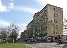
The six-storey building at Stralauer Platz 29–31 was added to the west of the office building / chapel as the Gasag administration building in 1936. However, the facade was covered with gray plaster. In the GDR era it served as a company vocational school for the VEB Energiekombinat Berlin. The house had to be demolished in 2017: it stood empty for years and was now in danger of collapsing.
Architecture of the central magazine
The warehouse complex, planned by the architects Konrad Reimer and Friedrich Körte and built between 1906 and 1908, consists of a four-storey clinker cladding structure with a steel structure, which made it possible to set up large, hall-like storeys with support spacings of around 4.5 meters. The facade at Stralauer Platz (originally number 29–34) is designed in the neo-baroque style , its ground floor area is set off by a cornice . The elongated six-axle construction has strung segmental arch windows and is equipped with a gable roof completed. The narrow sides are adorned with tail gables. Another building with six axes and a facade that is more in the neo-renaissance style belongs to the complex . It served as an office building . What is particularly striking here is a magnificently designed oriel made of sandstone and somewhat reserved window designs, which give it the character of a residential building. Both buildings are connected by a single-storey gatehouse with side entrances.
use
The open spaces on the south side of the square served as a 'municipal storage area' after the rubble had been removed, which had been temporarily stored here for removal by water. During the GDR era, the building complex of the central storage facility was part of the VEB Berliner Vergaser- und Filterwerke .
Building complex after 1990
After German reunification , the entire property became the property of the Berlin Senate . The historical area Zentralmagazin and Kontorhaus was extensively renovated and restored in 2001/2002 and is now the seat of the Zentrum Zukunftsenergien / International Solar Center and the Berlin Energy Agency ; summarized as Energieforum Berlin . The office building serves other companies such as a pin partner shop , a law firm and clubs. The former production building is empty (as of March 2012).
See also
literature
- Institute for Monument Preservation (Ed.): The architectural and art monuments of the GDR. Capital Berlin-I . Henschelverlag, Berlin 1984, p. 468 f .
Web links
- Stralauer Platz. In: Street name lexicon of the Luisenstädtischer Bildungsverein (near Kaupert )
Individual evidence
- ↑ a b Berlin city map from 1875. Retrieved on May 16, 2019 . : Stralauer Platz between Holzmarktstraße (west), Andreas- / Koppenstraße, Frankfurter Bahnhof (north), Fruchtstraße / Mühlenstraße (east) and the banks of the Spree (south).
- ↑ Berlin city map from 1893. Retrieved on May 16, 2019 . : Stralauer Platz and the surrounding area
- ↑ a b Berlin city map from 1932. Retrieved on May 16, 2019 . : Stralauer Platz and the surrounding area.
- ↑ a b The architectural and art monuments ... , p. 469.
- ↑ Information portal for the Friedrichshain-Kreuzberg district .
- ↑ Monument central store of the municipal gas works, 1906–1908 by Konrad Reimer and Friedrich Körte .
- ↑ a b c d Municipal gas works in Friedrichshain . In: District lexicon of the Luisenstädtischer Bildungsverein .
- ↑ a b Berlin and its buildings. Urban technology . Imhof Verlag, Petersberg 2006, ISBN 3-86568-012-7 ; Central magazine, p. 29 and 336.
- ^ (BBS) of VEB Energiekombinat "Ernst Zinna" Friedrichshain, vocational training facility, Berlin; on stayfriends.de ; accessed on March 24, 2019.
- ↑ Here the last ruin on Stralauer Platz disappears in www.bz-berlin.de; accessed on March 24, 2019.
- ↑ City map 1960. Retrieved on May 16, 2019 . : Stralauer Platz and the surrounding area
- ^ Website of the ISC with a photo of the reconstruction from the Spree side
- ^ Website of the ISC
Coordinates: 52 ° 30 '34.3 " N , 13 ° 25' 55.9" E


