Sumatran earthquake of September 2007
| Sumatran earthquake of September 2007 | ||
|---|---|---|
|
|
||
| date | September 12, 2007 | |
| Magnitude | 8.5 M W | |
| depth | 30 km | |
| epicenter | 4 ° 31 '12 " S , 101 ° 22' 26" E | |
| country |
|
|
| dead | 23 | |
| Injured | hundreds | |
|
|
||
The September 2007 Sumatran earthquakes were a series of earthquakes in the Sunda Trench off the coast of Sumatra , Indonesia , three of which had a magnitude greater than M w = 7.0. A number of tsunami warnings have been issued for the sea area. At least 25 people were killed and 161 injured, some seriously, as a result of the series of earthquakes.
Earthquake series
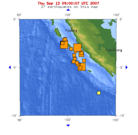
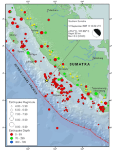
The first earthquake occurred on September 12, 2007 at 11:10:26 a.m. UTC (6:10:26 p.m. local time) and reached a magnitude of M w = 8.5 on the moment magnitude scale . The hypocenter of the quake was 34 km deep about 130 km southwest of Bengkulu on the southwest coast of the Indonesian island of Sumatra, more than 600 km west-northwest of the capital Jakarta . The quake was followed by various aftershocks along the same fault west of Sumatra, which reached a magnitude between 5 and 6.
The second largest quake with a magnitude of M w = 7.9 occurred a few hours later at 23:49:04 UTC (06:49:04 local time on the following day). Its hypocenter was about 10 km below the earth's surface, at 2 ° 30 ′ 21.6 ″ S , 100 ° 54 ′ 21.6 ″ E , about 185 km south-southeast of Padang , and 205 km northwest of Bengkulu and thus about 225 km northwest of the first strong earthquake.
After further aftershocks with a magnitude greater than five, another strong earthquake with a value of M w = 7.0 occurred on September 13 at 03:35:26 a.m. UTC (10:35:26 a.m. local time) . Its center was 2 ° 9 '36 " S , 99 ° 51" 3.6 " E , about 165 km south-southwest of Padang and 345 km west-northwest of Bengkulu, about 10 km below the surface.
The aftershocks continued on September 13th and 14th and some of them reached a magnitude of M w = 6.4. Most of the aftershocks were northwest of the original first very strong quake.
In the Indian Ocean distributed measuring buoys and other seismic instruments prompted the scientists warnings of a tsunami issue.
Effects
The tremors of the 8.5 M w earthquake lasted for several minutes. As a result, buildings in Jakarta swayed and it was reported that several buildings collapsed in the city of Bengkulu, about 130 km from the epicenter . Eyewitnesses in Jakarta described the tremors as "tremendous" . Several high-rise buildings were evacuated.
The tremors were also felt in surrounding states, such as southern Thailand and Singapore , which is about 670 km from the epicenter. On the Malay Peninsula , the tremors were recorded after 7.15 p.m. local time, including in Kuala Lumpur , Putrajaya , Johor Bahru , Malacca and Penang . As in Singapore and Jakarta, the tremors were most likely to be felt in high-rise buildings, resulting in panic and evacuations.
Tsunami
Observations of the sea level revealed that the quake triggered a tsunami. A total of four tsunami warnings were issued within 24 hours. After the first, the largest earthquake, the Pacific Tsunami Warning Center issued a tsunami warning for most of the Indian Ocean. A tsunami about three feet high was observed in Padang. A smaller tsunami with a height of just over 15 cm was registered on the Cocos Islands . After two hours, the tsunami warning in Sumatra was revoked.
Tsunami warnings were also raised in India and other states around the Indian Ocean after the quake . The government of India had urged the states of Tamil Nadu , Kerala and Andhra Pradesh , as well as the union territories of Andaman and Nicobar and Puducherry to be extremely vigilant. In the late evening of September 12, the warnings were lifted. Similarly, at 8:50 p.m. local time, an alarm was also raised on the Malay Peninsula for the coastal stretches of Perlis , Kedah , Perak and Penang ; this alarm was cleared two hours later. However, the Malaysian authorities had recorded a tsunami that reached between one and three meters in height.
Tectonic summary
According to the US Geological Survey , the earthquake was triggered by the thrust at the border between the Australian and Sunda plates . At the site of the earthquake off the western coast of Sumatra, the Australian plate moves northeast relative to the Sunda plate at a speed of 69 mm / year, at an angle to the alignment of the plate boundary. The plate movement perpendicular to the plate boundary causes the thrust on the plate off the coast.
The earthquake with a magnitude M w = 7.9 was also the result of a thrust at the same plate boundary. It occurred about 225 km northwest of the earthquake with a magnitude of 8.5 at the northern end of a zone in which the aftershocks were concentrated.
The earthquake with a magnitude M w = 8.5 was the strongest earthquake of 2007, stronger than the two Sumatra earthquakes of March 2007 in the vicinity and the earthquake in Peru in 2007 . It was the second strongest earthquake since the seaquake in the Indian Ocean in 2004 , which reached the magnitude M w = 9.3 and was only exceeded during the period by the seaquake off Sumatra in 2005 with a magnitude M w = 8.6. The two strongest aftershocks were the fourth and fifth earthquakes, which reached a magnitude of M w = 7.9 or more at or near the plate boundary off the west coast of Sumatra over the past seven years . The other earthquakes of this magnitude were on June 4, 2000 (magnitude M w = 7.9), then the seaquake on December 26, 2004 (magnitude M w = 9.3) and the seaquake off Sumatra on March 28, 2005 ( Magnitude M w = 8.6).
The two earthquakes occurred at the end of the southern part of a zone that was already pulled apart by the severe earthquake in 1833 and extends in the south from the island of Enggano in a north-westerly direction to the north of the island of Siberut . The 2004 Indian Ocean earthquake affected a large part of the border area between the Indian and Burma plates , and shortly afterwards on March 28, 2005, a segment of the connection between the Australian plate and the M w -8.6 earthquake shook the sunda plate . Much of the Sunda Trench between the Andamans and Eggano has been rocked by a series of earthquakes in the subduction zone since the December 26, 2004 earthquake that triggered the catastrophic tsunami .
Individual evidence
- ↑ a b Significant Earthquakes of the World: 2007. ( Memento of the original from October 4, 2008 in the Internet Archive ) Info: The archive link was inserted automatically and has not yet been checked. Please check the original and archive link according to the instructions and then remove this notice. United States Geological Survey (English)
- ↑ Magnitude 8.5 - SOUTHERN SUMATRA, INDONESIA , USGS
- ↑ Magnitude 7.9 - KEPULAUAN MENTAWAI REGION, INDONESIA ( Memento of the original from October 12, 2007 in the Internet Archive ) Info: The archive link was inserted automatically and has not yet been checked. Please check the original and archive link according to the instructions and then remove this notice. , USGS
- ↑ DART Buoy Station 23401 - 600 NM West-Northwest of Phuket, Thailand
- ↑ Message indian.2007.09.13.002807 Pacific Tsunami Warning Center, NWS , NWS PTWC
- ↑ Eyewitnesses: Sumatra earthquake , BBC News
- ↑ BBC News : Powerful quake shakes Indonesia , September 12, 2007
- ^ Tsunami alert issued after Indonesia quake: US center
- ↑ Event 2007hear: View Map ( Memento of the original from September 15, 2007 in the Internet Archive ) Info: The archive link was inserted automatically and has not yet been checked. Please check the original and archive link according to the instructions and then remove this notice. , September 12, 2007
- ↑ Singapore buildings sway after strong quake hits Indonesia , September 12, 2007
- ↑ a b 8.2 magnitude quake sparks tsunami warnings . Sun2Surf . September 13, 2007. Archived from the original on March 5, 2010. Info: The archive link was automatically inserted and not yet checked. Please check the original and archive link according to the instructions and then remove this notice. Retrieved September 13, 2007.
- ↑ Quake felt in Malaysia . The Star . September 13, 2007. Archived from the original on April 24, 2008. Info: The archive link was automatically inserted and not yet checked. Please check the original and archive link according to the instructions and then remove this notice. Retrieved September 13, 2007.
- ↑ Powerful earthquake triggers tsunami in western Indonesia ( Memento of the original from September 29, 2007 in the Internet Archive ) Info: The archive link was inserted automatically and has not yet been checked. Please check the original and archive link according to the instructions and then remove this notice. , The Jakarta Post
- ^ Tsunami recorded at Cocos Island , Herald Sun
- ^ India on tsunami alert after quake near Indonesia , CNN-IBN
- ↑ Tsunami alert withdrawn . The Hindu
- ↑ Magnitude 8.5 - Southern Sumatra, Indonesia
- ↑ Magnitude 7.9 - Kepulauan Mentawai Region, Indonesia ( Memento of the original from October 12, 2007 in the Internet Archive ) Info: The archive link was inserted automatically and has not yet been checked. Please check the original and archive link according to the instructions and then remove this notice.
Web links
- USGS Earthquake Center 8.4 tracking report
- USGS Earthquake Center 7.9 tracking report
- USGS Earthquake Center 7.0 tracking report
- Powerful earthquake hits Indonesia , The Daily Telegraph
- Indonesia earthquake kills one , The Guardian
- Quake Triggers Tsunami in Indonesia ( November 14, 2007 memento on the Internet Archive ), Associated Press
- Indonesia calls off tsunami warning , Channel NewsAsia (CNA)
- Tsunami alert issued after Indonesia quake: US center , CNA
- Singapore buildings sway after strong quake hits Indonesia , CNA


