Surcubamba district
| Surcubamba district | |
|---|---|
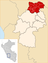
 The Surcubamba district is located in the northeast of Tayacaja Province (marked in red) |
|
| Basic data | |
| Country | Peru |
| region | Huancavelica |
| province | Tayacaja |
| Seat | Surcubamba |
| surface | 284 km² |
| Residents | 4927 (2017) |
| density | 17 inhabitants per km² |
| ISO 3166-2 | PE-HUV |
| politics | |
| Alcaldesa district | Nelfa Común Gavilán (2019-2022) |
Coordinates: 12 ° 7 ′ S , 74 ° 38 ′ W
The Surcubamba district is located in the Tayacaja Province in the Huancavelica region in southwest central Peru . The district emerged in the founding years of the Republic of Peru. It has an area of 284 km². The 2017 census counted 4,927 inhabitants. In 1993 the population was 5151, in 2007 it was 5112. The district administration is located in the 2585 m high town of Surcubamba with 674 inhabitants (as of 2017). Surcubamba is located 40 km northeast of the provincial capital Pampas . In the west of the district on the banks of the Río Mantaro is the hydroelectric power station of the Cerro del Águila dam .
Geographical location
The Surcubamba district is located in the Peruvian Central Cordillera in the northeast of the Tayacaja Province. The district is located on the right bank of the north-flowing Río Mantaro a few meters below the confluence of the Río Huanchuy. The east of the district is drained to the east via the Río Paraiso.
The district of Surcubamba borders in the south with the district Andaymarca , in the west with the districts Quishuar , Salcabamba and Salcahuasi , in the north with the district Pariahuanca (Huancayo) district Pariahuanca ( province Huancayo ), in the northeast with the district Huachocolpa and in the southeast with the district Tintay Puncu .
Localities
In addition to the main town, there are the following other larger towns in the district:
- Bellavista (304 inhabitants)
- Jatuspata (232 inhabitants)
- Matara
- Paucarmarca (252 inhabitants)
- Pueblo Libre (212 inhabitants)
- Sachacoto (345 inhabitants)
- Socos (200 inhabitants)
- Vista Alegre (306 inhabitants)
Web links
- Peru: Huancavelica region (provinces and districts) at www.citypopulation.de
- INEI Perú