Szczaniec
| Szczaniec | ||
|---|---|---|

|
|
|
| Basic data | ||
| State : | Poland | |
| Voivodeship : | Lebus | |
| Powiat : | Świebodzin | |
| Geographic location : | 52 ° 16 ' N , 15 ° 41' E | |
| Residents : | 1473 (2006) | |
| Postal code : | 66-225 | |
| Telephone code : | (+48) 68 | |
| License plate : | FSW | |
| Economy and Transport | ||
| Rail route : | Rzepin – Zbąszynek | |
| Next international airport : | Poznan-Ławica | |
| Gmina | ||
| Gminatype: | Rural community | |
| Gmina structure: | 12 localities | |
| 11 school offices | ||
| Surface: | 112.92 km² | |
| Residents: | 3847 (June 30, 2019) |
|
| Population density : | 34 inhabitants / km² | |
| Community number ( GUS ): | 0808042 | |
| Administration (as of 2006) | ||
| Mayor : | Ryszard Walkowiak | |
| Address: | Szczaniec 73 66-225 Szczaniec |
|
| Website : | www.szczaniec.pl | |
Szczaniec ( German Stentsch ) is a municipality in the powiat Świebodziński ( Schwiebus district ) in the Polish Lubusz Voivodeship .
Geographical location
The place is located in Lower Silesia , about ten kilometers east of the city of Schwiebus ( Świebodzin ) and twenty kilometers south-southeast of the city of Meseritz ( Międzyrzecz ).
history

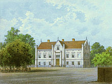
In the past, the village of Stentsch essentially consisted of two manors of roughly the same size, called Mittel-Stentsch and Ober-Stentsch . According to the Silesian vassal table, both shares were in the hands of 47-year-old Georg Gottlob von Knobelsdorff in 1752 . Around 1858 Mittel-Stentsch owned a von Kalckreuth , while Ober-Stentsch was owned by a judiciary Hünke. The two landlords exercised patronage over the Protestant village church.
The municipality counted to 1945 county Züllichau-Schwiebus in the administrative district of Frankfurt of the province of Brandenburg of the German Reich .
Towards the end of the Second World War , the Red Army occupied the region in the spring of 1945 . Soon afterwards Stentsch was placed under Polish administration. Subsequently, the local Polish administrative authorities evicted the local population and replaced them with Poles. The German village of Stentsch was renamed Szczaniec .
Population numbers
- 1858: 888, including 17 Catholics and two Jews
- 1933: 1.165
- 1939: 1.152
local community
The rural community of Szczaniec includes 12 districts ( German names up to 1945 ) with the Schulzenamt (sołectwo):
|
|
|
Nowe Karcze ( New World ) is another village in the municipality without a Schulzenamt.
Sons and daughters of the church
- Ferdinand Noske (1857- † unknown), German politician (DNVP)
- Ingeborg Sommer (1923–2001), German journalist, trade unionist and politician (SPD)
Web links
Footnotes
- ↑ population. Size and Structure by Territorial Division. As of June 30, 2019. Główny Urząd Statystyczny (GUS) (PDF files; 0.99 MiB), accessed December 24, 2019 .
- ↑ a b c W. Riehl and J. Scheu (eds.): Berlin and the Mark Brandenburg with the Margraviate Nieder-Lausitz in their history and in their current existence . Berlin 1861, pp. 521-522.
- ^ E. von Eickstedt: Contributions to a newer land book of the Brandenburg brands. Prelates, knights, cities, fiefdoms, or horse service and land guard . Magdeburg 1840, p. 571.
- ^ A b Michael Rademacher: German administrative history from the unification of the empire in 1871 to the reunification in 1990. zuellichau.html # ew39zllstent. (Online material for the dissertation, Osnabrück 2006).
- ↑ The Genealogical Place Directory


