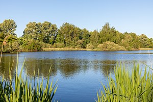
Ponds in the Heubach lowlands (COE)
|
Ponds in the Heubach lowlands
|
||
| location | North Rhine-Westphalia , Germany | |
| surface | 118.2 ha | |
| Identifier | COE-007K2 | |
| WDPA ID | 165846 | |
| Geographical location | 51 ° 49 ' N , 7 ° 13' E | |
|
|
||
| Setup date | 1987 | |
The former nature reserve Teiche in der Heubachniederung (COE) lies in the area of the city of Dülmen in the district of Coesfeld in North Rhine-Westphalia .
The approximately 118.2 hectare area with the key number COE-007K2, which was placed under nature protection in 1987 , extends southwest of the core city of Dülmen and west of Hausdülmen . The A 43 runs along the north-western edge and the L 551 state road to the east. The Heubach, the upper reaches of the Haltern Mühlenbach, flows through the area . Together with the parts in the Recklinghausen district, the nature reserve is in the FFH area of the same name.
The ordinance on the protected area has expired, a draft ordinance on the re-designation was published in 2018.
See also
Web links
Commons : Teiche in der Heubachniederung (COE) - Collection of pictures, videos and audio files
- Ordinance 1987
- Draft of the new expulsion regulation (2018)
- World Database on Protected Areas - Ponds in the Heubach Lowlands (COE ) (FFH area)
- Ponds in the Heubach lowlands on natur-erleben-nrw.de


