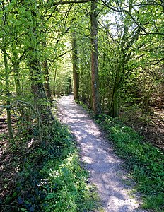
Forest near House Burlo
|
Forest near House Burlo
|
||
|
Paoters Pättken , a stick dam in the forest near Haus Burlo. |
||
| location | North Rhine-Westphalia , Germany | |
| surface | 223.3 ha | |
| Identifier | COE-061 | |
| WDPA ID | 329704 | |
| Geographical location | 52 ° 3 ' N , 7 ° 16' E | |
|
|
||
| Setup date | 2003 | |
The forest nature reserve near Haus Burlo is located in the municipality of Rosendahl in the Coesfeld district in North Rhine-Westphalia .
The approximately 223.3 hectare area, which was placed under nature protection in 2003 , extends northwest of Darfeld , a district of the municipality of Rosendahl. The Paoters Pättken , a centuries-old path that the monks of the Kleinburlo Abbey on the edge of the forest took to Darfeld, leads through the forest . The monastery buildings have largely been abandoned today, a few outbuildings, including the brewery and a former water mill, have been preserved. To the west of the Burloer Wald the Burloer Bach flows to the Klostermühle and flows a few kilometers further into the Vechte . The state road L 580 runs east of the Burlo forest and south the L 555.
See also
Web links
- Nature reserve "Wald bei Haus Burlo" in the specialist information system of the State Office for Nature, Environment and Consumer Protection in North Rhine-Westphalia
- World Database on Protected Areas - Forest near Haus Burlo (English)
Individual evidence
- ↑ Municipality of Rosendahl: Pure nature , accessed on August 22, 2018


