
Teletsk lake
| Teletsk lake | ||
|---|---|---|

|
||
| In the north of the lake | ||
| Geographical location | Altai Republic ( Russia ) | |
| Tributaries | Tschulyschman , Kyga, Bolschije Tschili, Kokschi, Kamga, Koldor | |
| Drain | Bija | |
| Data | ||
| Coordinates | 51 ° 32 ' N , 87 ° 43' E | |
|
||
| Altitude above sea level | 436 m | |
| surface | 223 km² | |
| length | 77.7 km | |
| width | 5.2 km | |
| scope | 181 km | |
| Maximum depth | 325 m | |
| Middle deep | 174 m | |
| Catchment area | 19,500 km² | |

The lake teletskoye or Teletskoye Lake (obsolete also Telezkischer or Teletzkischer lake ; Russian озеро Телецкое , Teletskoye Ozero , Altai. Altyn-Köl , literally "Golden Lake") is the largest lake in the Altai Mountains and the Altai Republic in Russia . It is one of the 25 deepest lakes on earth.
Geographical location and description
The Telezker See is 434 m above sea level. NN , is 77.8 kilometers long, up to 5.2 kilometers wide and has an area of 231 square kilometers. If the Kamginsk Bay is included, the length is 78.6 km. The average width is 2.9 km. The lake reaches its maximum width in the northern part, immediately west of the "sea knee" between the village of Jailju and the Idyp bay; it has the smallest width of 600 meters in the northwest at Cape Karatasch.

The lake is on average 174 meters deep. With a generally accepted maximum depth of 325 meters, it is the third deepest lake in Siberia and the fourth deepest in Russia after Lake Baikal and Lake Khantai. In terms of the deepest lakes in the world, it ranks 26th. According to more recent information, it should even be more than 340 meters deep. Its 41.1 cubic kilometers of water are so crystal clear that the depth of view is sometimes 12 to 15 meters.
The lake is known as the "Pearl of the Altai" and in many ways is similar to the larger Lake Baikal. Like the latter, Lake Teletsk also has the elongated shape of a continental rift due to its formation ; it has several tributaries - including the Chulyshman , Kyga, Bolschije Tschili, Kokschi, Kamga and Koldor rivers, but only one outlet: the 306 km long Bija , which after its confluence with the Katun forms the 3500 km long Ob . A total of about 70 rivers and 150, at times, watercourses flow into the lake, but more than half of the inflowing water comes from the Tschulyschman.
The lake is shaped like a knee. The southern main section has a length of 49.9 km and the northern branch of 27.9 km.
The lake includes two bays: in the northeast the Kamga Bay with a length of 6 km and in the south the Kyga Bay with 2 km, both named after the rivers that flow into the lake there. The island of Kamain is located in the Chulyshman estuary in the south of the lake.
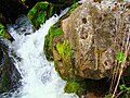
Dozens of waterfalls represent a special feature of the rocky shore. Among the most famous are the Korbu waterfall (12.5 meters), the Kishte waterfall (8 meters) and the Great Schaltap (up to 20 meters).
The lake is surrounded by mountain chains that rise up to a good 2500 meters (Baskon, 2502 m , east of the lake).
Flora and fauna
The catchment area of Lake Teletsk extends over an area of 20,400 km². More than 1200 plant species characterize the rich flora of the area. The variety of natural landscapes and the richness of the flora also determine a rich fauna. These include dozens of species of mammals ( bear , lynx , wolf , wolverine , sable , squirrel , Asian badger , rabbit , wild boar , ibex , muskrat and others), more than 300 species of birds, and around 10 types of reptiles and amphibians . 15 different fish species live in the lake. These include a. the Taimen , the Teletsk whitefish , the Teletsk white fish , the Teletsk grayling , pike , perch , burbot and the salmon fish Lenok ( Brachymystax lenok ). The taimen is the largest and most useful fish in Lake Teletsk. It is up to 1.50 meters long and weighs 50–60 kilograms.

Settlement and tourism
The Teletsk Lake is primarily located in the Turochak district; only the southern part belongs to the Ulagan district. The most important settlements at the northwest end include the villages Artybasch and Iogatsch, where the Bija leaves the lake. They can also be reached by bus from Gorno-Altaysk , the capital of the Altai Republic , via the paved road P 375 . The distance is 154 km. Also in the north of the lake is Jailju, the center of the Altai nature reserve. The Bele settlement on the eastern bank in the southern section of the lake belongs to the Ulagan district. Some settlements can only be reached by water (Balyktscha near the mouth of the Chulyshman) or with all-terrain vehicles (Jailju on the north bank). Ships invite you to lake excursions to waterfalls and grottos or to the southern river delta. Fishing is also popular.
For decades, Lake Teletsk has been one of the most popular and most frequently visited tourist destinations in the Altai Republic. There are more than 30 campsites and tourist camps; Most are in the northern part near Artybasch, Iogatsch and Jailju, but some are also in the Chulyshman estuary.

Banja (sauna) on the bank

Grotto on Lake Teletsk
Waterfall on the lake
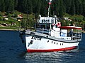
Ship excursion


Exploring the lake
The Russian geologist and explorer Gregor von Helmersen traveled to the Altai via Omsk and Barnaul in the spring of 1834. The first scientific description and recording of Lake Teletsk are due to this trip. He drove the lake lengthways, took height and temperature measurements, drew a precise picture of the mountain forest banks and gave the first more precise descriptions of the residents. The ethnographer and Turkologist Wilhelm Radloff , at that time a high school teacher at the imperial mountain school in Barnaul in western Siberia, also traveled the lake.
Today the Institute for Taxonomy and Ecology of Animals of the Siberian Department of the Russian Academy of Sciences operates a field base on the northwestern bank of Lake Teletsk, about 6 kilometers from the source of the Bija. For example, insectivores and rodents in the area, biocenoses of helminth fauna and vertebrates in the surrounding taiga as well as fish and plankton in the lake are examined here . The Tomsk State University leads there for more than 50 years of research by. Ecologists from the Institute for Water and Environmental Problems as well as geologists and archaeologists from the Siberian Department of the Russian Academy have been working there for many years. Geomorphologists and geologists study the geological structure, paleogeography, age and formation of Lake Teletsk. There is a sports and recreation center of the Gorno-Altaysky State University nearby.


literature
- T. Dulkejt: Teleckoe ozero c legendach i byljach . 2nd Edition. NIZ BiGPI, Biysk 1999, ISBN 5-85127-167-1 (Russian).
- Gregor von Helmersen: The Telezkischer See and the Teleuts in the eastern Altai . Saint Petersburg 1838.
- Gregor von Helmersen: Journey to the Altai, carried out in 1834 . Book printing of the Imperial Academy of Sciences, Saint Petersburg 1848.
- A. Maloletko: Teleckoe ozero po issledovanijam 1973-1975 vs. 2nd edition. Tomsk 2009 (Russian).
- A. Nikolaeva: Ėcho pesen Altyn-Këlja. Skazka . Print-info, Barnaul 2005, ISBN 5-88449-130-1 (Russian).
- Wilhelm Radloff: Journey through the Altai to the Telezker See and the Abakan . Edited by Georg Adolf Erman . In: Archives for Scientific Customer of Russia . tape XXIII , no. 4 . Berlin 1865.
Web links
- Travel report from Lake Teletsk
- Telezker See photo gallery
- Topographic map of Lake Teletsk , scale 1: 200,000 (Russian)
Individual evidence
- ↑ a b Lake Teletsk in the State Water Register of the Russian Federation (Russian)
- ↑ a b c d e Article Telezker See in the Great Soviet Encyclopedia (BSE) , 3rd edition 1969–1978 (Russian)
- ↑ a b Characteristics of Lake Teletsk ( Memento of the original from April 4, 2011 in the Internet Archive ) Info: The archive link was automatically inserted and not yet checked. Please check the original and archive link according to the instructions and then remove this notice. (Russian)
- ↑ a b Description of the Telezker See ( page no longer available , search in web archives ) Info: The link was automatically marked as defective. Please check the link according to the instructions and then remove this notice. (Russian)
- ↑ a b c Wassili Oinoschew: Altyn Köl - Telezker See, in: Kulturschatz Altai - Series: Heritage of the Peoples of the Russian Federation, pp. 30–35, NIIZentr 2004, ISBN 5-902156-04-1 (Russian)
- ↑ Information on Lake Teletsk on the official website of the Altai Republic ( Memento of the original from June 9, 2012 in the Internet Archive ) Info: The archive link was automatically inserted and not yet checked. Please check the original and archive link according to the instructions and then remove this notice. (Russian)
- ↑ a b Lake Teletsk (Russian)
- ↑ Animals of Lake Teletsk ( Memento of the original from April 4, 2011 in the Internet Archive ) Info: The archive link was inserted automatically and has not yet been checked. Please check the original and archive link according to the instructions and then remove this notice. (Russian)
- ↑ Fish of the Telezker See ( Memento of the original from April 4, 2011 in the Internet Archive ) Info: The archive link was automatically inserted and not yet checked. Please check the original and archive link according to the instructions and then remove this notice. (Russian)
- ↑ Tourist stations on Lake Teletsk (Russian)
- ↑ Website of the Institute for Taxonomy and Ecology of Animals ( Memento from January 6, 2015 in the Internet Archive ) (Russian)