
Maharraka Temple
| Nubian monuments from Abu Simbel to Philae | |
|---|---|
|
UNESCO world heritage |
|

|
|
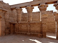
| East side of the Temple of Maharraka |
|
| National territory: |
|
| Type: | Culture |
| Criteria : | i, iii, vi |
| Surface: | 374.48 ha |
| Reference No .: | 88 |
| UNESCO region : | Arabic states |
| History of enrollment | |
| Enrollment: | 1979 ( session 3 ) |
The Temple of Maharraka (also transcribed Maharraqa ) is an ancient Egyptian hypostyle hall that stands today in New Sebua on the western side of Lake Nasser in the Egyptian part of Nubia (Lower Nubia ). The original location was about 30 kilometers northeast of the Wadi el-Alaki near the village of al-Maharraqa , the Greco-Roman Hiera Sykaminos ( ancient Greek Ἱερὰ Συκάμινος ). The portico stood on a plateau above the flat and sandy west bank of the Nile at this point . In order to save the temple from the rising water of Lake Nasser, the reservoir of the Nile that was dammed up by the Aswan High Dam , it was dismantled in 1961 and rebuilt in its current location in 1966. The temples of Dakka and Wadi es-Sebua, which are also offset, are in the immediate vicinity.
Location and description
The Hypostyle Hall of the Temple of Maharraka is located approximately 134 kilometers south of the Aswan High Dam and 108 kilometers northeast of the Temples of Abu Simbel . The building is made of sandstone and was rebuilt after restoration between the 160 meters away shore of Lake Nasser and the 180 meters to the west of the Dakka Temple. About 860 meters to the south is the temple of Wadi es-Sebua, which was only moved 2.7 kilometers to the northwest and after which the current location is named New Sebua.

The outer wall of the 13.56 × 15.69 meter large hall of the temple of Maharraka encloses a courtyard surrounded on three sides by columns. While four columns were set up on the west side, opposite the east entrance, there are five in the north and south without the west corner columns. The southern row of columns has inter- column walls (partition walls ) with a central and an eastern passage. The spiral staircase in the northeast corner of the pillared hall, which leads to the roof that is only partially available today, is unique for Egyptian temple buildings.

In addition to the main entrance in the east, there are three roughly equal entrances to the portico. These are located on the west corners of the north and south walls of the temple as well as in the west wall, but not in the center, but somewhat offset to the south as an extension of the passage of the two southern columns on the west side of the hall. This and the upper outer ends of the walls with an originally circumferential chamfer , also on the western outer wall, imply that no extension of a temple house with an adyton or sanctuary was planned at the rear . This raises the question of whether the reconstruction of the portico is based on an open courtyard or a closed roof.
The covings on the lintel on the inside and outside of the eastern main entrance are decorated with relief images of the winged sun disk . The arched chiselling in the inner lintel comes from the later conversion into a Christian apse , in which the entrance was closed. The incompletely machined blanks of the column capitals show that various shapes, from a simple bell to complex composite structures made of floral elements, were to be executed, but were not completed. The few executed reliefs are on the south wall behind the partition walls with the central passage.
- Views of the temple

Northwest side

Main entrance

Column capitals
Southern partitions


history
Approximate coordinates of the original location: 23 ° 02 ′ 49 ″ N, 32 ° 41 ′ 03 ″ E

By the time the Maharraka Temple was discovered, parts of the walls had collapsed. Johann Ludwig Burckhardt , who crossed al-Maharraqa on both sides of the Nile in March 1813, assumed an earthquake as the cause when he wrote about the temple walls that they had "fallen, apparently due to a sudden and violent tremor, because the stones are on the ground the floor in the same way as they were placed in the standing wall; proof that they must all have fallen over together. ”During the relocation work to the current location by the Egyptian antiquities administration , the collapsed walls were erected again. In older travel reports, the ruin of the pillared hall is also referred to as the temple of Ofendina or Hofeduineh after the nearer eastern neighboring village.

The lack of embellishment with reliefs and the incompletely worked capitals of the hypostyle hall indicate that the temple was never completed. The earthquake that caused the hall walls to collapse can be ruled out as a reason for this, as the intact building functioned as a church in Christian times. The eastern entrance was walled up and converted into an apse. Due to the almost complete lack of relief representations and inscriptions, the exact date of construction of the temple of Maharraka cannot be determined. It is believed that it was laid out on a stone terrace above the west bank of the Nile as early as the Ptolemaic period . Two picture registers of early travelers are documented on the southern wall of the interior, of which only small remains are today and the anonymous king according to the hieroglyphic inscriptions above with the sacrifice in front of Osiris-Wennefer (Onnophrys), Isis and Horus and below with the Show presentation of crop yields to Thoth from Pnubs ( Kerma ) and Tefnut .
_01.jpg)
_01.jpg)
While the few hieroglyphic and demotic inscriptions name Isis and Osiris as the main deities of the temple, the Greek inscriptions from Roman military personnel mention Isis and Serapis . In hieroglyphs, Isis appears a few times as “mistress of Philae ” or Osiris as “lord of Abaton ” at the same time as “guest in (ḥrj-ib) Km-s3 ”. Two demotic proskynemata at the temple record the worship "before Osiris, Isis and Nephthys , the gods of Km-s3 " and "Isis of Ty-km [-s3] ". In addition to the worship of the gods mentioned, the inscriptions indicate that the temple of Maharraka was in the area of Tachompso ( ancient Greek Ταχομψώ ), the southernmost part of the twelve-mile country ( ancient Greek δυώδεκα σχοῖνοι Dodekaschoinos ). Here was the border town of Hiera Sykaminos, which in turn is mentioned in a Greek Proskynema at the temple, in which the worship "[of the greatest god] in Hiera [sykaminos Sarapis and the] thousand-named [en Isis]" can be added.
The toponym Hiera Sykaminos (Ἱερὰ Συκάμινος for "Holy sycamore ") is expected to a sacred grove be due, for which there was a notice in the immediate vicinity of the original location of the Temple of Maharraka. On a kind of path from the Nile to the north wall of the portico, a relief in Egyptian-Hellenistic mixed style was attached to a free-standing wall of a collapsed chapel, which showed the seated Isis in Greco-Roman robe under a sycamore tree as the main scene. A hawk hovered over her while another lay in the branches of the tree. She stretched out her arms to a boy, Horus, dressed in a toga and bringing her a vessel of wine . Above him three small figures in Roman style showed Min , Isis and Serapis and on the right Isis, depicted in an Egyptian way. The wall was already dismantled after the construction of the old Aswan High Dam and taken to the museum in Cairo to save it from the water in the reservoir.
Hiera Sykaminos was under Ptolemaic and Roman rule on the southern border of the Dodekaschoinos , the twelve-mile country. She formed since the Treaty of Samos 21/20 BC. BC to AD 298 the border between the Roman and the Meroitic empires . A name cartouche of the Roman emperor Nero dates from this time , which the Nubia traveler Algernon Percy (Lord Prudhoe) claims to have identified on one of the walls of the temple of Maharraka in January 1828. The inscription of a Geminius Fronto, which indicates the veneration of Serapis as a sun god, is secured. From this and the alignment of the pillared hall, the Egyptologist and ancient historian Günther Hölbl concluded that the complex could have been a solar sanctuary , a simple sun temple on an ancient hill . This is also supported by the representation of the originally Nubian sun god Mandulis (Merulis) behind Horus on a stone block that Richard Lepsius found in the temple of Maharraka in November 1843.
literature
_01.jpg)
|
_02.jpg)
|
|
|
Richard Lepsius: Maharraka. In: Monuments from Egypt and Ethiopia , Volume V, pages 78 and 79 |
||
- Richard Lepsius : Monuments from Egypt and Ethiopia . Eduard Naville. Fifth volume of text. Hinrichs'sche Buchhandlung, Leipzig 1913, Maharraka, p. 78–79 ( digitized (reprint) ).
- Richard A. Lobban, Jr .: Historical Dictionary of Ancient and Medieval Nubia (= Historical Dictionaries of Ancient Civilizations and Historical Eras . No. 10 ). Scarecrow Press, Lanham, Maryland, Oxford 2004, ISBN 0-8108-4784-1 , Maharraqa, Maharraka, Hierasykaminos, pp. 242-243 (English, online ).
- Joachim Willeitner : Abu Simbel and the temples of Lake Nasser. The archaeological guide . von Zabern , Darmstadt, Mainz 2012, ISBN 978-3-8053-4457-9 , Der Serapis-Tempel von Maharraqa , p. 57–61 ( digitized version of the table of contents [PDF]).
Web links
Individual evidence
- ^ Dieter Arnold : Lexicon of Egyptian architecture . Albatros, Munich, Zurich 1994, ISBN 978-3-7608-1099-7 , El-Maharraqa, p. 145 .
- ↑ a b c Friederike Herklotz: Prinzeps and Pharao: The cult of Augustus in Egypt . Antike, Frankfurt am Main 2007, ISBN 978-3-938032-15-2 , El Maharraqa / Hiera Sykaminos, p. 145–146 ( online [accessed November 19, 2019]).
- ↑ gates Kjeilen: Temple of Maharraqa. lexicorient.com (English).
- ↑ a b Joachim Willeitner: Abu Simbel and the temples of Lake Nasser. The archaeological guide . von Zabern, Darmstadt, Mainz 2012, ISBN 978-3-8053-4457-9 , Der Serapis-Tempel von Maharraqa , p. 59-60 .
- ↑ Johan Ahlfeldt: About: Hierasykaminos, el-Maharraqa. Digital Atlas of the Roman Empire. Lund University, August 1, 2013 (English).
- ^ Johann Ludwig Burchhardt: Travels in Nubia . John Murray, London 1819, Return from Dar-el-Mahass to Assouan, p. 100 (English, digitized version ).
- ↑ a b c d e Joachim Willeitner: Abu Simbel and the temples of Lake Nasser. The archaeological guide . von Zabern, Darmstadt, Mainz 2012, ISBN 978-3-8053-4457-9 , Der Serapis-Tempel von Maharraqa , p. 58-59 .
- ↑ Giovanna Magi: Abu Simbel - Aswan and the temples in Nubia . Bonechi, Florence 2007, ISBN 978-88-476-2033-9 , Maharraka, p. 106-107 ( online [accessed November 19, 2019]).
- ↑ a b Josef Locher (Ed.): Topography and history of the region on the first Nile cataract in Greco-Roman times . Stuttgart, Leipzig 1999, ISBN 978-3-11-095738-9 , Tachompso, p. 262 ( online [accessed November 19, 2019]).
- ↑ Josef Locher (Ed.): Topography and history of the region on the first Nile cataract in Greco-Roman times . Stuttgart, Leipzig 1999, ISBN 978-3-11-095738-9 , Tachompso, p. 263 ( online [accessed November 19, 2019]).
- ^ Robert B. Jackson: At Empire's Edge: Exploring Rome's Egyptian Frontier . Yale University Press, New Haven, London 2002, ISBN 0-300-08856-6 , Roman Nubia: Hiera Sykaminos (Maharraqa), pp. 142 (English, online [accessed November 19, 2019]).
- ↑ Hermann Grapow : Hierasykaminos . In: Paulys Realencyclopadie der classischen Antiquity Science (RE). Volume VIII, 2, Stuttgart 1913, Sp. 1407 ( online ).
- ↑ Josef Locher (Ed.): Topography and history of the region on the first Nile cataract in Greco-Roman times . Stuttgart, Leipzig 1999, ISBN 978-3-11-095738-9 , Philai, p. 136 ( online [accessed November 19, 2019]).
- ↑ Richard Lepsius : Monuments from Egypt and Ethiopia . Eduard Naville. Volume V: Nubia, Hammamat, Sinai, Syria and European museums. Hinrichs'sche Verlagsbuchhandlung, Leipzig 1913, Maharraka, p. 79 ( digitized version [accessed on November 21, 2019]).
Aswan: Elephantine | Aswan Islamic Cemetery | Qubbet el-Hawa | Simeon Monastery | Aswan quarries and obelisk
Nubian temples: Abu Simbel | Amada | Bet el-Wali | Dakka | Derr | Kalabsha | Kertassi kiosk | Maharraka | Philae | Wadi Sebua
Coordinates: 22 ° 48 ′ 3 ″ N , 32 ° 32 ′ 51.3 ″ E