
Tguma
| Tguma | ||
|---|---|---|
 Tguma from Alp Bischola |
||
| height | 2163.1 m above sea level M. | |
| location | Canton of Graubünden , Switzerland | |
| Mountains | Adula Alps | |
| Dominance | 1.99 km → Lüschgrat | |
| Notch height | 164 m ↓ Bischolpass | |
| Coordinates | 746 578 / 175968 | |
|
||
 Summit cross and the less comfortable western flank |
||

The Tguma is a summit east of Safien and west of Thusis in the canton of Graubünden in Switzerland with an altitude of 2163 m above sea level. M. It belongs to the Heinzenberggrat . From the Heinzenberg side it is inconspicuous as a grass hill, from the Safiental side it is rocky and steeper. Due to its proximity to the Tschappina Heinzenberg and Sarn-Heinzenberg ski areas , the Tguma is a popular, easy-to-reach ski touring mountain.
Location and surroundings
The Tguma belongs to the Heinzenberggrat, a subgroup of the Adula Alps . At the summit, the municipal boundaries between Safien and the Sarn and Portein fractions , which belong to the Cazis municipality , meet . The Tguma is bordered in the east by the Heinzenberg and in the west by the Safiental .
The neighboring peaks include the Präzer Höhi and the Lüschgrat .
Valley locations are Safien, Flerden and Sarn. Frequent starting points are the Glaspass and Lüschalp.
Origin of name
Tguma corresponds to the Surselvian word cauma and means resting place for the cattle at noon . The word comes from the Greek word cauma for heat from the sun .
Heinzenberger tightrope walk

The Heinzenberger ridge hike is a scenic and varied day hike over the Heinzenberger ridge. It offers a great panoramic view of the Safien Valley, Domleschg , Albula Valley and the surrounding mountains.
A little tightrope walk
- Starting point: Obertschappina ( 1577 m )
- Destination: Prec ( 1170 m )
- Route: Obertschappina - Ober Gmeind ( 1813 m ) - Lüsch ( 1974 m ) - Bischolpass ( 1999 m ) - Tguma ( 2163 m ) - Präzer Höhi ( 2119 m ) - Alp Gronda ( 1883 m ) - Prec
- Difficulty: T2 , as trail white-red-white highlighted
- Duration: 5 h
Extensive balancing act
- Starting point: Glaspass ( 1831 m )
- Destination: Bonaduz ( 662 m )
- Route: Glaspass - Glaser Grat ( 2124 m ) - P. 1989 - Lüschgrat ( 2178 m ) - Bischolpass ( 1999 m ) - Tguma ( 2163 m ) - Präzer Höhi ( 2119 m ) - Crest dil Cut ( 2015 m ) - Crest Ault ( 1942 m ) - Alp Sura ( 1771 m ) - Alp Sut ( 1506 m ) - Scardanal ( 1131 m ) - P. 692 - Bonaduz
- Difficulty: T3 , mostly as trail white-red-white marks
- Duration: 8 h
Routes to the summit
Summer routes
From the glass pass
- Starting point: Glaspass ( 1831 m )
- Via: Bruuchalp, Lüsch ( 1974 m ), Bischolpass ( 1999 m )
- Marked as a white-red-white hiking trail
- Difficulty: T2
- Time required: 2 hours from the Glaspass, 1 hour from Lüsch or ¾ hours from the Bischolpass
- Alternative 1: From the Glaspass to Lüsch over the Glaser Grat (+ ½ hour)
- Alternative 2: From Bruuchalp to Bischolpass via Lüschgrat (+ ¾ hour)
From Safiental over the south ridge
- Starting point: Safien Platz ( 1296 m ) or Safien Neukirch ( 1292 m )
- Via: From Safien Platz to the Glaspass or from Safien Neukirch to the Bischolpass and then according to the route Vom Glaspass
- Marked as a white-red-white hiking trail
- Difficulty: T2
- Time required: 3½ hours from Safien Platz or 3½ hours from Safien Neukirch
From Obertschappina over the south ridge
- Starting point: Obertschappina ( 1577 m )
- Via: Ober Gmeind ( 1813 m ), Lüsch and then according to the route Vom Glaspass
- Marked as a white-red-white hiking trail
- Difficulty: T2
- Time required: 2 hours from Obertschappina or 1½ hours from Ober Gmeind
Over the eastern slope
- Starting point: Oberurmein ( 1579 m ), Flerden ( 1231 m ) or Sarn ( 1178 m )
- Marked as a white-red-white hiking trail
- Difficulty: T2
- Time required: 2 hours from Oberurmein, 3 hours from Flerden or 3 hours from Sarn
Over the north ridge
- Starting point: Präzer Höhi ( 2220 m )
- Marked as a white-red-white hiking trail
- Difficulty: T2
- Time required: 1 hour
From Safiental over the north ridge
- Starting point: Under Egschi ( 1154 m )
- Marked as a white-red-white hiking trail
- Difficulty: T3
- Time required: 3¾ hours
Winter routes
From the Tschappina Heinzenberg ski area
- Starting point: Rascheins mountain station ( 1910 m )
- Route: Bischolpass
- Difficulty: WS-
- Time required: 1 hour
From the Sarn-Heinzenberg ski area
- Starting point: Sarner Höhi mountain station
- Via: Parsiras ( 1822 m )
- Difficulty: WS-
- Time required: 1 hour from Parsiras
panorama

gallery

Tguma from the south, with Alp Bischola in the foreground

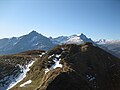
View of Piz Beverin , Bruschghorn (from left to right) and Lüschgrat in the foreground
Tguma from the north

Hut approx. 1 km north of the summit

Summit cross

Wooden cross on the ridge between Tguma and Präzer Höhi


.jpg)

.jpg)
literature
- Bernard Condrau: Club Guide, Bündner Alpen, Volume 2 (Bündner Oberland and Rheinwaldgebiet) 4th edition. Verlag des SAC, 1981, ISBN 3-85902-025-0 , pp. 301-302.
- National map of Switzerland, sheet 1215 Thusis, 1: 25000, Federal Office of Topography, 1985 edition.
Web links
- Panorama from the Tguma
- www.hikr.org Tour reports
- Tschappina Heinzenberg ski area
- Sarn-Heinzenberg ski area
Individual evidence
- ↑ Andrea Schorta: How the mountain got its name. Small Rhaetian name book with two and a half thousand geographical names of Graubünden . Terra Grischuna Verlag, Chur / Bottmingen / Basel 1988, ISBN 3-7298-1047-2 , p. 141 .
- ↑ Andrea Schorta: How the mountain got its name. Small Rhaetian name book with two and a half thousand geographical names of Graubünden . Terra Grischuna Verlag, Chur / Bottmingen / Basel 1988, ISBN 3-7298-1047-2 , p. 75 .