
Tiergarten district
The Tiergartenviertel is an area in the Tiergarten district of Berlin . Because of the distinctive development with many diplomatic institutions, the western part of the Tiergartenviertel is also called the diplomatic quarter or embassy quarter. In the founding years it was known as the residence of many high officials in the Privy Council district .
location
The quarter is named after the Great Zoo . Its green spaces extend to Tiergartenstrasse , which borders the quarter to the north. To the east, behind Potsdamer Strasse, are the new buildings on Potsdamer Platz . The southern border is formed by the Landwehr Canal , which arches to the light rail system in the west.
history

For the former excursion area in front of the city wall of the city of Berlin, King Friedrich Wilhelm III. 1828 the development plan. In the second half of the 19th century an extensive villa colony was built there and senior officials, entrepreneurs, artists and scientists moved there, as the central location between old Berlin , Charlottenburg and Schöneberg was combined with the advantages of suburbs. The 274 hectare area of the former zoo was incorporated in 1881. In the Wilhelminian city of Berlin, the Tiergartenviertel was officially called Lower Friedrichsvorstadt .
Since the quarter is in the center of Berlin, Albert Speer's plans for the “ World Capital Germania ” envisaged profound changes. The embassies of the friendly states Japan and Italy were erected as the first structures . In addition, the state acquired large parts of the property, partly through the expropriation of Jewish owners. In the eastern part of the Tiergartenviertel - east of Stauffenbergstrasse (until 1955: Bendlerstrasse ) - large parts of the existing buildings were demolished from 1938 to create space for the “ north-south axis ” and the “round square” between the dome hall and the south station . The western part - between Tiergartenstrasse in the north, Landwehr Canal in the south, Bendlerstrasse in the east (today: Stauffenbergstrasse) and Tiergartenstrasse in the west (today the part of Thomas-Dehler-Strasse that adjoins the expansion area of the zoo ) - was declared an embassy district.
After many buildings had already been damaged by air raids during World War II , almost every building was destroyed during the Battle of Berlin . The planned reconstruction began with the “Capital Berlin” competition in 1958. As Kulturforum Berlin , a center for culture, education and science was created in the east of the quarter. After German reunification and the capital city resolution , Berlin became the capital of Germany again. Then several states established new embassies in the Tiergarten district or restored the existing buildings.
building
- Bendlerblock with the Federal Ministry of Defense
- Berlin Philharmonic
- St. Matthew Church
- Picture gallery
- Decorative Arts Museum
- Kupferstichkabinett
- Musical instrument museum
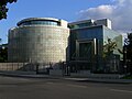
- New National Gallery
- Villa von der Heydt
- Krupp representative, today Canisius College
- Shell house
- Academy of the Konrad Adenauer Foundation
Diplomatic missions in the embassy district
- Egyptian embassy
- Bahraini embassy
- Estonian Embassy
- Indian embassy
- Italian embassy
- Japanese embassy
- Luxembourg Embassy
- Malaysian Embassy
- Maltese Embassy
- Mexican embassy
- Nordic embassies (Denmark, Finland, Iceland, Norway and Sweden)
- Austrian Embassy
- Senegalese Embassy
- Spanish embassy
- South African Embassy
- Turkish embassy
- Syrian Embassy
- Saudi Arabian Embassy
- Embassy of the United Arab Emirates
Built as diplomatic missions, today different use
- Former Danish embassy , currently being converted into a hotel
- Former Yugoslav embassy , today the seat of the German Society for Foreign Policy
- Former Norwegian embassy , now office and residential building

New National Gallery (rear view)

The café on the Neuer See
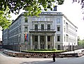
Spanish embassy on Lichtensteinallee

Main entrance to the museums
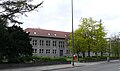
Catholic grammar school Canisius-Kolleg

The copper band of the Nordic embassies

The Bendlerblock on the Landwehr Canal
Embassy of Saudi Arabia on Tiergartenstrasse

Japanese embassy on Tiergartenstrasse


Former residents and buildings
- Association of Berlin Artists , Bellevuestrasse 3
- Royal Wilhelms-Gymnasium , Bellevuestrasse 15
- Karl Richard Lepsius , Bendlerstrasse 18
- Emil and Walter Rathenau , Viktoriastraße 3/4
- Adolph vom Rath , Viktoriastraße 6
- Carl Fürstenberg , Viktoriastraße 7
- Eduard Georg Simon , Viktoriastraße 7
- Hermann Roeder , Viktoriastraße 14
- Erich Ludendorff , Viktoriastraße 26
- Helmuth James Graf von Moltke , worked at Viktoriastraße 33
- Paul Cassirer Art Salon , Viktoriastraße 35
- Tilla Durieux , first Margaretenstrasse 1, then Viktoriastrasse 35
- The Tiele-Winckler family , Regentenstrasse 15, today Hitzigallee 21
- James Simon , Tiergartenstrasse 15a
- Berlin Secession , Tiergartenstrasse 21a
- Marie von Olfers , Margaretenstrasse 7
literature
- Olav Münzberg: From the old west to the culture forum: Tiergartenviertel in Berlin. Changes in an urban landscape . Das Arabisches Buch, Berlin 1988, ISBN 3-923446-37-3 .
- Hartwig Schmidt : The Tiergarten District. Building history of a Berlin villa district . Mann, Berlin 1981, ISBN 3-7861-1277-0 .
- Katrin Wehry: Across the Tiergarten district. The historic quarter and its residents . Nicolai, Berlin 2015, ISBN 978-3-89479-946-5 .
Web links
- Kathrin Chod, Herbert Schwenk, Hainer Weisspflug: Tiergartenviertel . In: Hans-Jürgen Mende , Kurt Wernicke (ed.): Berliner Bezirkslexikon, Mitte . Luisenstadt educational association . Haude and Spener / Edition Luisenstadt, Berlin 2003, ISBN 3-89542-111-1 ( luise-berlin.de - as of October 7, 2009).
Individual evidence
- ↑ Berlin's embassies in the diplomatic quarter. April 5, 2012. Retrieved November 22, 2018 .
Coordinates: 52 ° 30 ' N , 13 ° 22' E