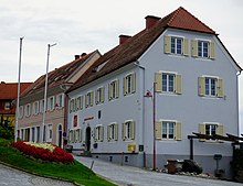
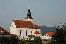
Trautmannsdorf in Eastern Styria
|
Trautmannsdorf in Oststeiermark ( village ) village Trautmannsdorf Cadastral community Trautmannsdorf |
||
|---|---|---|
|
|
||
| Basic data | ||
| Pole. District , state | Südoststeiermark (SO), Styria | |
| Judicial district | Feldbach | |
| Pole. local community | Bad Gleichenberg | |
| Coordinates | 46 ° 52 ′ 0 ″ N , 15 ° 53 ′ 0 ″ E | |
| height | 326 m above sea level A. | |
| Residents of the village | 730 (January 1, 2020) | |
| Building status | 306 (2001 ) | |
| Area d. KG | 7.29 km² | |
| Postcodes | 8343, 8344 | |
| prefix | + 43/3159 | |
| Statistical identification | ||
| Locality code | 14815 | |
| Cadastral parish number | 62160 | |
| Counting district / district | Trautmannsdorf in Oststeiermark (62369) | |
| Independent municipality until the end of 2014 Source: STAT : Local directory ; BEV : GEONAM ; GIS-Stmk |
||
Trautmannsdorf in Oststeiermark is a district of the municipality of Bad Gleichenberg with 877 inhabitants (as of January 1, 2014) in the south-east of Styria in the district of Southeast Styria .
geography
Trautmannsdorf in East Styria is located approx. 48 km southeast of Graz and approx. 9 km south of the district capital Feldbach in the East Styrian hill country .
The cadastral municipality of Trautmannsdorf comprises the following two localities (number of inhabitants in brackets, as of January 1, 2020):
- Hofstatten (113)
- Trautmannsdorf (730)
history
Trautmannsdorf is the cradle of the von Trauttmansdorff family of the same name , whose family tree dates back to 984.
On January 1, 2015, Trautmannsdorf was merged with the municipalities of Bairisch-Kölldorf , Merkendorf and Bad Gleichenberg as part of the municipal structural reform in Styria . The new community bears the name "Bad Gleichenberg".
Culture and sights
- Parish church hl. Michael : In the baroque parish church is the grave of Count Herrand von Trauttmansdorff from the 13th century.
- Funeral hall
- Crypt chapel
- Grave monument of the Hötzl family
- Memorial stone in the Israelite cemetery
societies
- Mountain and nature watch
- Vocativ ensemble
- church choir
- Trautmannsdorf volunteer fire brigade
- Parish Council
- Austrian Comradeship Association, Trautmannsdorf local association
- Catholic women's movement
- The Traut'ther (Trautmannsdorf theater group)
- Trachtenmusikkapelle Trautmannsdorf
- Riding club Trautmannsdorf / surroundings
- Senior citizens' union Trautmannsdorf
- Bullet Flash Trautmannsdorf (paintball)
- Hunting party
- Tennis club Trautmannsdorf
Population development

Personalities
Sons and daughters of the place
- Alois Reicht (* 1928), postal worker and politician
Connected to the community
- Anton Ausserer , Austrian naturalist and arachnologist , was buried in Trautmannsdorf in 1889.
Web links
Individual evidence
- ↑ Statistics Austria: Population on January 1st, 2020 by locality (area status on January 1st, 2020) , ( CSV )
- ^ Announcement of the Styrian state government of December 19, 2013 about the union of the municipalities Bad Gleichenberg, Bairisch-Kölldorf, Merkendorf and Trautmannsdorf in East Styria, all political districts of Southeast Styria. Styrian Provincial Law Gazette of December 30, 2013. No. 186, 38th issue. ZDB ID 705127-x . P. 763.
- ^ Associations - Trautmannsdorf community


