
Troitskoye (Kalmykia)
Village
|
||||||||||||||||||||||||||||
|
||||||||||||||||||||||||||||
|
||||||||||||||||||||||||||||
| List of large settlements in Russia | ||||||||||||||||||||||||||||
.svg)

Troitskoje ( Russian Тро́ицкое , Kalmyk Булһн селән ) is a village (selo) in the Republic of Kalmykia in Russia with 11,943 inhabitants (as of October 14, 2010).
geography
It lies in the southern part of the Jergenihügel , well 10 km straight line north of the Republic capital Elista . It is located on a small, temporarily water-bearing river that flows a good 10 km east into the Jaschkul , the main tributary of the outflowless Dejed-Chulsun lake .
Troizkoje is the administrative center of the Rajons Zelinny and seat and only town in the rural community Troizkoje selskoje posselenije. Almost two thirds of the population are Kalmyks , a good quarter are Russians . After the towns of Elista and Lagan , Troitskoye is the third largest town in Kalmykia in terms of inhabitants.

Culture house and library

Buddhist temple (Churul)
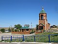
New Trinity Church
Memorial to the victims of the deportation of the Kalmyks

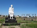
The white old man


history
The place was founded in 1862 by Russian resettlers from the Voronezh governorate not far from a Kalmyk winter camp. The name is derived from Troiza, Russian for Holy Trinity , to which a now defunct wooden church was consecrated, which was moved there from the village of the same name in the Voronezh governorate.
On January 24, 1938, Troitskoye became the administrative seat of the Troitski rajon ( Ulus ) of the Kalmyk Autonomous Oblast named after him . During the German-Soviet War , the village was occupied by the German Wehrmacht from summer until the end of 1942 . After the dissolution of the Autonomous Oblast and the deportation of the Kalmyk population, the district administration was transferred to Elista, renamed Stepnoje , and the district was named Stepnowski.
With the restoration of Kalmuck autonomy on January 12, 1957 (from 1958 as Kalmuck ASSR ) Troitskoye again became the center of a Rajon under the new name Zelinny, from Russian zelina for new territory .
Population development
| year | Residents |
|---|---|
| 1939 | 1,981 |
| 1959 | 2,450 |
| 1970 | 5,362 |
| 1979 | 6,469 |
| 1989 | 8,717 |
| 2002 | 10,298 |
| 2010 | 11,943 |
Note: census data
traffic
Troitskoye is located on the Volgograd - Elista branch of the federal trunk road R22 Kaspi (formerly M6), the main route of which connects Kashira near Moscow with Astrakhan . The nearest train station is in Elista, the end point of a route from Kropotkin (Kawkasskaja) via Palagiada near Stavropol (currently only freight traffic, as of 2013).
Web links
Individual evidence
- ↑ a b Itogi Vserossijskoj perepisi naselenija 2010 goda. Tom 1. Čislennostʹ i razmeščenie naselenija (Results of the All-Russian Census 2010. Volume 1. Number and distribution of the population). Tables 5 , pp. 12-209; 11 , pp. 312–979 (download from the website of the Federal Service for State Statistics of the Russian Federation)
| Cities |
Gorodovikovsk R | Elista S | Lagan R |
|
| Other Rajon centers |
Bolshoi Zaryn | Iki-Burul | Yashalta | Yashkul | Kettschenery | Komsomolski | Malyje Derbety | Prijutnoye | Sadovoye | Troitskoye | Zagan Aman |