
Sadowoje (Kalmykia)
| Village
Sadovoye
Sadovoe
|
||||||||||||||||||||||||||||||||||
|
||||||||||||||||||||||||||||||||||
|
||||||||||||||||||||||||||||||||||
.svg)

Sadowoje ( Russian Садо́вое ) is a village (selo) in the Republic of Kalmykia in Russia with 6530 inhabitants (as of October 14, 2010).
geography
The place is located in the northern part of the Jergeni Hills , a good 160 km as the crow flies north of the republic capital Elista and about 100 km south of Volgograd . It is located on the temporarily water-bearing Selmen River, which is lost about 20 km to the east in the drainless valley occupied by the chain of Sarpa lakes.
Sadowoje is the administrative center of Sarpinski Rajons and the seat of the rural community Sadovskoye selskoje posselenije, which also includes the settlement of Arym 7 km southwest. Ethnic Russians make up a good three quarters of the population (this exceeds the value for the entire Rajon, where they are also just in the majority), Kalmyks only barely 12%.

Apartment buildings in Sadovoye

Former bus station (2015)
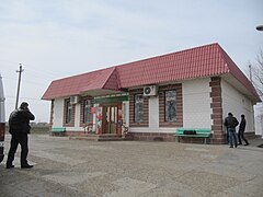
Shop at the bus station

Transmitter mast at Sadowoje


history
The place was established in 1849 as Staniza Sadowaja (from Russian sad for " garden ") as a result of an ukase from Emperor Nicholas I of December 30, 1846 to settle the areas along the connecting routes through the parts of the Astrakhan governorate populated by Kalmyks by founding 44 stanizi . Since the original plans to settle the nomadic Kalmyks there initially failed, Russian farmers from the governorates of Kharkov , Tambov and Voronezh were persuaded to resettle.
Towards the end of the 19th century, Stanitsa, like most of the others, was transformed into an ordinary village under its current name and, as the seat of a Volost, was subordinated to the Ujesd Chorny Yar of the Astrakhan governorate, although it is located on the territory of the specially administered so-called Kalmuck steppe ( Kalmyzkaya step) .
After the founding of the Kalmyk Autonomous Oblast in 1920, Sadowoje came with the introduction of the rajon structure from January 1930 to the Sarpinski rajon, named after the Sarpa lakes, which took up a larger area than today, with its provisional seat in Dede-Lamin (formerly the summer camp of the Maloderbetowski ulus of the nomadic Kalmyks; today as a place no longer exists). On January 24, 1938, the Rajon was reduced to its present size by hiving off the Kettschenerowski and Maloderbetowski rajon, with a new administrative center in the village of Vershin -Sal (today Kanukowo) 40 km southwest of Sadowoje . A little later the district administration was transferred to Sadowoje; During this period, the form of the name Sadowka , which is still used colloquially among the inhabitants, was also official for a time.
During the German-Soviet War , the village was occupied by the Axis powers from summer 1942 . The front came to a standstill in mid-August only a good 15 km east along the Sarpa Lakes, so that Sadowoje was repeatedly fought over and heavily destroyed in the following months: an attack by the Red Army on the Romanian troops stationed in the village from September 29 to October 4th failed, and the village could only be taken temporarily from November 6th to 9th, before it was finally recaptured on November 20, 1942 during Operation Uranus , the counter-offensive near Stalingrad.
After the dissolution of the Autonomous Oblast and the deportation of the entire Kalmuck population, the Rajon was attached to the Stalingrad Oblast (today Volgograd), but with the restoration of the Kalmuck autonomy on January 12, 1957 (from 1958 as the Kalmuck ASSR ) its part again.
Population development
| year | Residents |
|---|---|
| 1897 | 1506 |
| 1939 | 3289 |
| 1959 | 3926 |
| 1970 | 5876 |
| 1979 | 7207 |
| 1989 | 7342 |
| 2002 | 6505 |
| 2010 | 6530 |
Note: census data
traffic
The branch line Volgograd - Elista of the federal trunk road R22 Kaspi , whose main route connects Kashira near Moscow with Astrakhan , runs east of the place .
In a north-westerly direction in Sadowoje the regional road 85K-14 branches off to the border with Volgograd Oblast 15 km away, from there to the 40 km distant village Abganerowo , where the regional road 18K-1 is reached, part of the connection Volgograd - Salsk . The nearest railway station Abganerowo on the Volgograd - Tichorezkaya (- Krasnodar ) line is located about 50 km from Sadowoje . The 85K-15 runs from Sadowoje first to the southwest via Kanukowo, which also, but further away, reaches the 18K-1 and the railway line in Kotelnikowo in Volgograd Oblast.
Web links
- Official website of the rural community (Russian)
Individual evidence
- ↑ a b Itogi Vserossijskoj perepisi naselenija 2010 goda. Tom 1. Čislennostʹ i razmeščenie naselenija (Results of the All-Russian Census 2010. Volume 1. Number and distribution of the population). Tables 5 , pp. 12-209; 11 , pp. 312–979 (download from the website of the Federal Service for State Statistics of the Russian Federation)
| Cities |
Gorodovikovsk R | Elista S | Lagan R |
|
| Other Rajon centers |
Bolshoi Zaryn | Iki-Burul | Yashalta | Yashkul | Kettschenery | Komsomolski | Malyje Derbety | Prijutnoye | Sadovoye | Troitskoye | Zagan Aman |