Chikoi
|
Tschikoi Чико́й, Цѳх гол (Tsöch gol) |
||
|
Location of the Tschikoi in the catchment area of the Selenga (right) |
||
| Data | ||
| Water code | RU : 16030000212116300009089 | |
| location |
Transbaikalia Region , Republic of Buryatia ( Russia ), Selenge-Aimag ( Mongolia ) |
|
| River system | Yenisei | |
| Drain over | Selenga → Angara → Yenisei → Arctic Ocean | |
| source |
Draw cocoon Mountain 49 ° 37 '41 " N , 109 ° 56' 23" O |
|
| Source height | approx. 1800 m | |
| muzzle |
Selenga coordinates: 51 ° 3 ′ 28 " N , 106 ° 39 ′ 4" E 51 ° 3 ′ 28 " N , 106 ° 39 ′ 4" E |
|
| Mouth height | 535 m | |
| Height difference | approx. 1265 m | |
| Bottom slope | approx. 1.6 ‰ | |
| length | 769 km | |
| Catchment area | 46,200 km² | |
| Discharge at the Gremyachka A Eo gauge : 15,600 km² Location: 385 km above the mouth |
MQ 1942/1997 Mq 1942/1997 |
106 m³ / s 6.8 l / (s km²) |
| Discharge at the gauge Povorot A Eo : 44,700 km² Location: 22 km above the mouth |
MQ 1936/1997 Mq 1936/1997 |
273 m³ / s 6.1 l / (s km²) |
| Left tributaries | Tschikokon , Aza , Mensa , Katanza , Chuderiin gol | |
| Navigable | Lower course | |
|
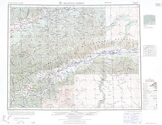
Middle course with the mouth of the cafeteria near Krasny Tschikoi before 1955 (topographic map 1: 250,000) |
||
The Tschikoi ( Russian Чико́й , Mongolian Цѳх гол Tsoch gol ) is a 769 kilometers long right tributary of the Selenga in Russian Transbaikalia and along its border with Mongolia . The Tschikoi is by far the most water-rich tributary of the Selenga.
course
The Tschikoi rises at an altitude of about 1800 m on the southeast flank of the Tschikokon Mountains . This southeastern foothill of the Daurian Mountains has a high mountain character in this area with heights over 2,500 meters; The Tschikoiski Golez ( 2334 m ) rises above the source of the Tschikoi . Initially, the Tschikoi flows in a northeastern direction. Its valley forms the border between the Daurian and the southeastern western part of the Borschtschowotschnygebirge . Then the river turns to the north, cuts through the 1,600 to 2,000 meter high main ridge of the Daurian Mountains and the Tscherski Mountains of the same height (not to be confused with the Tscherski Mountains of the same name in northeast Siberia).
Further north, the river turns sharply west to south-west. It flows here on the territory of the Transbaikalia region , later reaching the autonomous republic of Buryatia and the border between Russia and Mongolia ( Selenge-Aimag ), which it follows for more than 100 kilometers. About 30 kilometers west of Kjachta , the Chikoi turns again to the north and finally flows into the Selenga, the largest tributary of Lake Baikal, at Novoselenginsk , about 25 kilometers southwest of Gussinoosjorsk at an altitude of 535 m .
Especially in the lower reaches the river forms meanders and many branches. The most important tributary is the 337 kilometer long cafeteria (Russian Менза , Mongolian Минж гол / Mindsch gol ), as well as Tschikokon, Aza, Katanza (Ar-Chadants gol) and Chuderiin gol (also Chudriin gol; all from left).
Hydrography
The catchment area of the Tschikoi covers 46,200 km². Near the mouth, the river is up to 200 meters wide and three meters deep; the flow velocity is 1.3 m / s.
The chikoi freezes from late October / November to April / early May. It can freeze right through to the bottom in sections in the upper reaches.
The mean water flow at Poworot , about 20 kilometers above the mouth, is 274 m³ / s, with a minimum monthly mean of 17.7 m³ / s in March and a maximum monthly mean of 712 m³ / s in August. The Chikoi is flooded throughout the summer and autumn months.
Infrastructure
The Tschikoi is navigable in the lower reaches, for example from the Mongolian border.
There are many smaller towns on the middle and lower reaches, but no towns directly on the river. The A340 trunk road runs near the mouth from Ulan-Ude to Kjachta and the Mongolian border. To the places on the middle course of the river around Krasny Chikoi and the health resort Jamarowka lead two roads crossing the low mountain range ( Malchan Mountains ) north of the river : the regional road 76К-018 from Baljaga near Petrowsk-Sabaikalski and another, unpaved road to Chilok .
Individual evidence
- ↑ a b Article Tschikoi in the Great Soviet Encyclopedia (BSE) , 3rd edition 1969–1978 (Russian)
- ↑ a b Tschikoi in the State Water Register of the Russian Federation (Russian)
- ↑ Tschikoi at the Gremyachka gauge - hydrographic data from R-ArcticNET
- ↑ Tschikoi at the Povorot gauge - hydrographic data from R-ArcticNET

