
Subway line 4 (Berlin)
| Line Berlin U-Bahn small profile |
|||||||||||||||||||||||||||||||||||||||||||||
|---|---|---|---|---|---|---|---|---|---|---|---|---|---|---|---|---|---|---|---|---|---|---|---|---|---|---|---|---|---|---|---|---|---|---|---|---|---|---|---|---|---|---|---|---|---|
  | |||||||||||||||||||||||||||||||||||||||||||||
| Route length: | 2.9 km | ||||||||||||||||||||||||||||||||||||||||||||
| Gauge : | 1435 mm ( standard gauge ) | ||||||||||||||||||||||||||||||||||||||||||||
| Power system : | side busbar painted above 750 V = |
||||||||||||||||||||||||||||||||||||||||||||
|
|||||||||||||||||||||||||||||||||||||||||||||

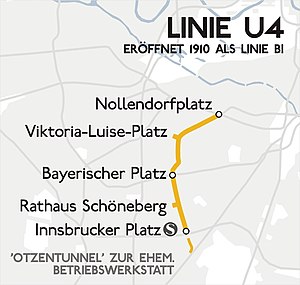
The U4 line of the Berlin subway has five stations and is 2.9 kilometers long. It runs as a pure Berlin-Schöneberger line from Nollendorfplatz to Innsbrucker Platz . The route was never extended beyond its original length and no major extensions are planned. Like the U1 , U2 and U3 lines , it is part of the Berlin “ small profile network”.
When it opened in December 1910, it was the pride of the then independent city of Schöneberg and is of importance as Germany's first municipal underground line . However, it is also the shortest of the Berlin underground lines.
course
The route of the U4 begins under Else-Lasker-Schüler-Strasse on Nollendorfplatz and initially runs under Motzstrasse in a south-westerly direction to Viktoria-Luise-Platz . The route then swings under Münchener Strasse in a left curve and follows it to Rosenheimer Strasse. From there it leads through Heilbronner Straße to Bayerischer Platz , where it has crossed the U7 since 1971 , and continues under Innsbrucker Straße to Innsbrucker Platz. Since 1933, there is a transition to the S-Bahn - Ring Line possible.
Line identification colors and designations
![]()
Since the trains of today's U4 line continued on the east-west elevated railway line in the direction of Kreuzberg (to Kottbusser Tor or Warschauer Straße ) from 1926 to 1954 , they were also given the line designation B (initially B I , later B II , then again B I , in May 1957 then B III ) and later also green as the line identification color. With the conversion to digits in 1966, it was given the name Line 4 . Until 1972 it was shown in blue on the route network maps. The color was changed to a light yellow and a year later to ocher yellow for better visibility. From 1961 the Schöneberg subway ended at Nollendorfplatz, as the traffic flow shifted in the direction of the Zoologischer Garten / Kurfürstendamm and the lines to the Kottbusser Tor or the Schlesisches Tor were not needed.
history

.jpg)
The city of Schöneberg wanted to develop its area well and so in 1903 the idea of building an underground railway came up. Talks were held with the Berlin elevated railway company . However, the interests of the partners did not match, because the short distance promised to bring no profit. So the city of Schöneberg took matters into its own hands and planned the first municipal subway in Germany. The line was supposed to run as an underpaved railway from Nollendorfplatz, on which the elevated station of the Berlin elevated and underground railway already stood, to the main street in the south of Schöneberg. An extension to the north was not ruled out, even a stretch to Weißensee was considered. First, however, the stations Nollendorfplatz (own tunnel station in Motzstrasse in front of the existing high station), Viktoria-Luise-Platz, Bayerischer Platz, Stadtpark (since May 15, 1951: Schöneberg Town Hall) and Hauptstrasse (since July 1, 1933: Innsbrucker Platz) planned. The company workshop was to be built south of the Hauptstrasse station .
Siemens & Halske A.-G. was responsible for the entire construction work, including equipping the line and delivering the vehicles. instructed. All standards were adapted to the already existing Berlin elevated and underground railway, as a direct connection to the route network of the elevated railway company was planned in the future. Therefore, the route was built with the dimensions and electrical equipment of the Berlin small profile network. The groundbreaking ceremony took place on December 8, 1908, in a mood similar to a festival.
In parallel with the construction of the underground, the Rudolph-Wilde-Park was built , which at that time was called Stadtpark like the station . Since the park was built on a swampy fen up to 30 meters deep, the excavation of the tunnels with a total volume of around 850,000 m³ was used to drain and fill it. After just two years of construction, the line was opened on December 1, 1910. However, the celebrations were very cautious, as the greatest Schöneberg supporter of the underground, Mayor Rudolph Wilde , had died a month earlier.
Since the Schöneberg subway was (initially) completely separate from the (other) Berlin network, extra facilities had to be built for it. This included own cars, a converter plant and the depot with workshop. A pedestrian tunnel was built between the two Nollendorfplatz stations as the only connection to the Berlin underground network.
The tunnel was continued in Eisackstrasse south of the Hauptstrasse train station on Innsbrucker Platz . There was a three-track sweeping and parking facility in the tunnel . The access track to the workshop branched off from the western track and swiveled in its own tunnel to Otzenstrasse , where it reached daylight on the workshop premises. At the corner of Traegerstrasse and Otzenstrasse, a tunnel exit can still be seen today. At the end of the workshop area there was another short tunnel in which the access track ended. The workshop received a five-track wagon hall and a two-track workshop hall. The small Schöneberg workshop became dispensable with the opening of the new transfer station at Nollendorfplatz in 1926 and was therefore shut down in 1932, as a permissive exchange of vehicles and the access to the large workshops of the elevated railway at the Stadion station (renamed the Olympiastadion since 1951 ) and at the Warschauer Brücke station became possible. The Waldenburg High School was built on the workshop premises after the Second World War .

The city of Schöneberg was the builder and owner of the line, but transferred the operation to the Berliner Hochbahngesellschaft. The different ownership conditions for the passengers did not appear at all, as a tariff community had been agreed one day before the opening.
On November 27, 2010, on the occasion of the 100th anniversary of the Schöneberg subway, a special service with a historical set (type A1) took place.
business

The U4 line is the only Berlin underground line that does not offer continuous nighttime traffic on weekend nights . The shortest trains run on the U4, which are planned to consist of only two cars.
| line | Mon-Fri (HVZ) (7 am-9am and 3 pm-6:30pm) |
Mon-Fri (NVZ) (4: 30–7 a.m.; 9 a.m. – 3 p.m. and 6.30 p.m. – 0.30 a.m.) |
Sa (5:30 am - midnight) |
Sunday and public holidays (7 a.m. - 12 a.m.) |
Off-peak time (Sat + Sun 0-0: 30 pm and Sun, 5: 30-7 pm) |
|---|---|---|---|---|---|
| Nollendorfplatz ↔ Innsbrucker Platz | 5 min | 10 min | 10 min | 10 min | 15 minutes |

The trains on line U4 ran fully automatically from 1981 to 1985 in test operation and from 1985 to 1993 in passenger operation ; In purely technical terms, no driver would have been necessary for this. For this purpose, the entire U4 was equipped with the SelTrac operations control system, which included, among other things, the installation of a line train control system in all tracks, an adaptation of the signal boxes and the equipping of 16 small-profile double railcars with SelTrac vehicle devices. SelTrac from Standard Elektrik Lorenz (SEL) enabled driving with absolute braking distances with train intervals of just 50 to 90 seconds. In 1988 an additional attempt was started for train driver self-handling (ZSA), which was tested in passenger operation from 1992 and later developed further for self-handling of drivers.
Route planning

|
|
|||||||||
|---|---|---|---|---|---|---|---|---|---|
|
|||||||||
| → See: Senate Department for Transport and Enterprises | |||||||||

The far-reaching expansion plans from the early days of the Schöneberg subway can no longer be implemented today.
In the north, however, an extension to Magdeburger Platz has been considered since the 2000s , which is to be “taken into account in the planning” as an extension target in the coalition agreement of the Senate . According to the planning status of the former Senate Department for Transport and Enterprises , a transfer option (Genthiner Straße) to the long-term planned U10 line ( current planning ) is to be provided. In August 2012, however, the Senate, in response to a small inquiry from the House of Representatives , announced that, according to a rough assessment by the BVG, a significant shift in traffic was not to be expected and therefore “a further examination of the extension of the U4 underground line is from the point of view of the Senate is currently not a priority. "
In the south, extensions would only be possible with great effort due to the tunnel section of the newly built motorway city ring at Innsbrucker Platz, which is at the same altitude . The underground tracks of the U4 would intersect both the pedestrian distribution level and the upper area of the motorway tunnel. Even if the U4 line were to be lowered, not only the motorway tunnel, but also the platform tunnel of the U10 line planned during the occupation would have to be underpassed. This would require corresponding ramp lengths, which would have to result in a completely new construction of the section south of Bayerischer Platz. The effort required for this would be relatively high because of the depth to be achieved on this section of the route, especially in relation to the traffic benefits of a - then extended - U4 line.
It should be noted that the U10 line is the (same) working title used at different times for two different, in both cases not implemented, underground lines.
literature
- Gerlach, Friedrich: The electric subway of the city of Schöneberg . In: Zeitschrift für Bauwesen , Volume 61 (1911), Col. 93–134, 261–322, Plate 15–20. kobv.de
- Jan Gympel: 100 years of the Schöneberg subway . Herrndorff, Berlin 2011, ISBN 978-3-940386-01-4 .
- Reinhard Arf: 100 years of the Schöneberg subway . In: Verkehrsgeschichtliche Blätter , Volume 37, Volume 6 (November / December 2010), pp. 158–171, Volume 38, Volume 1 (January / February 2011), pp. 21-23.
Web links
- Information on the U4 underground line on the BVG website
- History and historical photos of the Schöneberg subway
- Photos of the train stations in the Berlin subway gallery
Individual evidence
- ^ Brian Hardy: The Berlin U-Bahn . Capital Transport, Harrow Weald 1996, ISBN 1-85414-184-8 , pp. 86 .
- ↑ Bahninfo: 100 years of Schöneberg underground and BVG Christmas market on November 27, 2010
- ↑ Mark Jurziczek v. Lisone: The SelTrac test farm . In: Berlin traffic pages. 2010, accessed December 2, 2011 .
- ↑ Senate Department for Transport and Enterprises, as of 1995
- ↑ Berlin's subway lines ( Memento from March 11, 2007 in the Internet Archive )
- ^ Coalition agreement 2011–2016
- ↑ Senate Department for Transport and Companies, as of 1995 ( Memento from March 4, 2016 in the Internet Archive )
- ↑ Testing and planning project for the extension of underground line 4 from Nollendorfplatz to Magdeburger Platz (PDF; 26 kB)