Umvoti
| Umvoti Umvoti Local Municipality |
||
|---|---|---|
 |
||
| Symbols | ||
|
||
| Basic data | ||
| Country | South Africa | |
| province | KwaZulu-Natal | |
| District | Umzinyathi | |
| Seat | Greytown | |
| surface | 2,515.6 km² | |
| Residents | 103.093 (October 2011) | |
| density | 41 inhabitants per km² | |
| key | KZN245 | |
| ISO 3166-2 | ZA-KZN | |
| Website | www.umvoti.gov.za (English) | |
| politics | ||
| mayor | Mthandeki Petrus Ngubane | |
| Political party | Inkatha Freedom Party | |
Coordinates: 29 ° 4 ′ S , 30 ° 35 ′ E
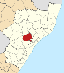
Umvoti (also uMvoti ; English Umvoti Local Municipality ) is a municipality in the South African district of Umzinyathi in the province of KwaZulu-Natal . The administrative seat of the parish is Greytown . Mthandeki Petrus Ngubane is the mayor. The ANC has the majority in the local council.
The parish was named after the Umvoti River . It covers an area of 2516 square kilometers.
geography
The community consists mainly of rural areas, of which 70 percent is agricultural land and 30 percent is part of the Ingonyama Trust , (a trust foundation that is supposed to secure land for the indigenous people).
Umvoti borders on Msinga and Nkandla (the latter in King Cetshwayo district ) to the north and Maphumulo (in iLembe district ) to the east . South of the municipality are Ndwedwe (iLembe) and uMshwathi ( uMgungundlovu ) and to the west of Mpofana (uMgungundlovu).
places
- Greytown
- Crane
- Kwa Sizabantu Mission
history
Umvoti parish was created through the merger of the two former parishes of Greytown and Kranskop. The village of Umvoti was founded by the Land Commission and renamed Greytown in 1854 in honor of the Governor of the Cape Colony , Sir George Gray. In the local language the place was called Ungungundlovana ( isiZulu for "the place of the little elephant"). After the demarcation of the municipality and the elections on December 5, 2000, the municipal council decided to name the newly delimited area Umvoti.
population
In 2011 the community had 103,093 inhabitants. 94.6% of them were black, 2.2% each were white or Indian or Asian and 0.8% colored .
The first language was 89.1% isiZulu , 4.9% English and 0.9% Afrikaans and isiNdebele each .
economy
In terms of traffic, Umvoti is connected via the R33 and R74 . The two regional roads cross in the center of the municipality. The R622 connects Greytown with the Mooi River . The largest lake in the parish is Merthley Dam .
Greytown is the economic center of the community. Over a quarter of the residents work here. Agriculture is the largest employer in Umvoti. About 85 percent of the skilled workforce is employed on commercial farms. Most of the economic activity in this sector is concentrated in forestry. The areas around Greytown and along the Umvoti River are very suitable for agricultural land. The other areas are only mediocre or not at all suitable. The problem is that Umvoti is far from the respective markets. This makes it difficult for smallholders to start commercial cultivation. There are also hardly any further processing companies, which means that the raw products have to be sold and the finished goods have to be bought again. A second mainstay in the community is the manufacturing industry. Although the community has a lot of potential, there is hardly any tourism in Umvoti.
Attractions
- KwaShushu Hot Springs
- Lilani Hot Springs
- Itshe likaBhambatha
- Ngome Game Reserve
Web links
- Side of the community. on www.umvoti.gov.za (English)
- The Local Government Handbook: Umvoti Local Municipality (KZN245) . on www.localgovernment.co.za (English)
- Top Business Portfolio: Umvoti Local Municipality . on www.kzntopbusiness.co.za (English)
- Integrated Development Plan (IDP) as reviewed 09-10. (PDF; 2.11 MB) Umvoti Municipality, accessed on June 5, 2010 (English).
Individual evidence
- ↑ Contact information: Umvoti Local Municipality. (No longer available online.) Government Communication and Information System , archived from the original on September 3, 2011 ; accessed on February 7, 2010 (English). Info: The archive link was inserted automatically and has not yet been checked. Please check the original and archive link according to the instructions and then remove this notice.
- ^ The Local Government Handbook - A complete guide to municipalities in South Africa. Umvoti Local Municipality (KZN245). Yes! Media, accessed December 26, 2016 .
- ^ South African Language - Place Names. Retrieved June 5, 2010 .
- ↑ Umvoti. (No longer available online.) Municipal Demarcation Board , formerly original ; accessed on June 5, 2010 (English). ( Page no longer available , search in web archives ) Info: The link was automatically marked as defective. Please check the link according to the instructions and then remove this notice.
- ↑ a b About uMvoti. (No longer available online.) UMvoti Municipality, archived from the original on October 12, 2008 ; accessed on January 31, 2009 . Info: The archive link was inserted automatically and has not yet been checked. Please check the original and archive link according to the instructions and then remove this notice.
- ↑ http://www.statssa.gov.za/?page_id=993&id=umvoti-municipality
- ^ Ward Delimitation 2009 - Supplementary Map. (No longer available online.) Municipal Demarcation Board , formerly original ; accessed on June 6, 2010 (English). ( Page no longer available , search in web archives ) Info: The link was automatically marked as defective. Please check the link according to the instructions and then remove this notice.
- ↑ a b KwaZulu-Natal Top Business (Ed.).
- ↑ Umvoti Municipality (ed.), P. VIIf.
- ↑ a b Umvoti Municipality (Ed.), S. XV.
