Velay

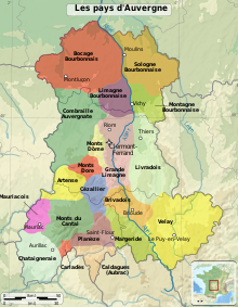
The Velay ( Occitan Velai ) is a landscape shaped by extinct volcanic cones in the southeast of the French massif Central . For a long time it belonged to the province of Languedoc and since the French Revolution it has formed the main part of the Haute-Loire department . For Robert Louis Stevenson , the place Le Monastier-sur-Gazeille was the starting point for his journey with the donkey through the Cevennes, which he undertook in 1878 .
geography
location

The Velay, with its deep valleys, is located in the southeast of the Massif Central between the Allier valley in the west and the hills on the west side of the Rhône . It is a low mountain range with the 1200 to 1435 m high Meygal massif near Queyrières in the center; The highest point, however, is Mont Mézenc, approx. 20 km south of it, at 1753 m .
- To the east and northeast is the granite plateau of Tence
- In the south the basalt plateau of the Massif du Mézenc
- To the west and south-west the basin of Le Puy-en-Velay and the volcanic plateau of the Velay
- To the north the granite plateau of Craponne-sur-Arzon .
Rivers
The most important rivers in or on the edge of the Velay are the Allier, Loire and Lignon du Velay . There are also smaller rivers such as the Gazeille and numerous streams.
places
The capital of the overall rather sparsely populated Velay is Le Puy-en-Velay (approx. 19,000 inhabitants); Monistrol-sur-Loire (approx. 8,700) and Yssingeaux (approx. 7,200) are smaller and less known . The place La Chaise-Dieu (only approx. 600) is historically significant .
economy
The most important branch of business in the Velay was and is agriculture and here primarily cattle breeding, which is favored by lush pastures, on the basis of which a regional cheese is made. Also known are the lace makers (dentelles) of the region, whose craftsmanship was passed on to subsequent generations by the “Beaten”.
history
The Gaulish settlement of the Velay seems to have been weak, at the time of the Roman conquest of Gaul, the tribe of the Vellavers settled here . The nominal capital was until the 5th century Ruessium (= "well located"), today Saint-Paulien ; In fact, however, it has always been Le Puy-en-Velay that has been the political and economic center of the country. About 200 years after the collapse of the Roman Empire , the Merovingians and later the Carolingians took control of the area. Even before his three-year-old son Louis the Pious was appointed King of Aquitaine in 781, 14 counties were formed - one of which was Velay. Its first count was Buhl or Bulus (ruled 771–792). Since around the year 835, the counties of Velay and Auvergne formed a political unit, which since Raimund III. was claimed by the Counts of Toulouse in the 10th century . Starting from Le Puy, one of the four main routes of the Way of St. James ( Via Podiensis ) ensured a lively cultural exchange in the Middle Ages.
After the area was integrated into the Kingdom of France, the Velay was added to the Languedoc and the Sénéchaussée Beaucaire . The country was represented in the Parliament of Languedoc, but settled its affairs in annual assemblies, the États du Velay , itself. Political life was dominated by constant arguments between the nobility and the bishop and between Catholics and Protestants .
During the Second World War , the Velay formed a region of resistance against the Vichy regime and later against the German occupiers. Many Jews also fought in groups of the Resistance known as the Maquis .
Attractions
The wooded landscape of the Velay and the stone-built houses in the old towns and town centers are well worth seeing. Artistic highlights are the Romanesque cathedral of Le Puy , which was heavily revised in the 19th century, and the Saint-Michel d'Aiguilhe chapel, about 1 km away, built on a rock needle . The new building of the Abbey of La Chaise-Dieu was in the 14th century by Pope Clement VI, who resided in Avignon . (1342–1352) was commissioned as his burial place and a good 25 years after his death by his grandson Gregory XI. accomplished; In the years between 1410 and 1425 the originally 26 m long wall fresco of a dance of death was created .
literature
- Louis Simonnet: Aspects de la vie rurale en Velay dans l'Antiquité. In: Cahiers de la Haute-Loire 1979 , Le Puy-en-Velay
- Gilles Charreyron: Politique et Religion. Protestants et catholiques de la Haute-Loire. Clermont-Ferrand, Presses de l'Université Blaise-Pascal 1990
- Sylvain Bruand: Une introduction au Velay médiéval. La comptabilité des évêques du Puy (1343-1435). In: Cahiers de la Haute-Loire 2018 , Le Puy-en-Velay 2018
- Jérôme Sagnard: Le Velay en 200 questions. Editions Alan Sutton, 2013

