Varaignes (river)
|
Varaignes Ruisseau de Crochet, Ruisseau de l'Étang d'Assat |
||
|
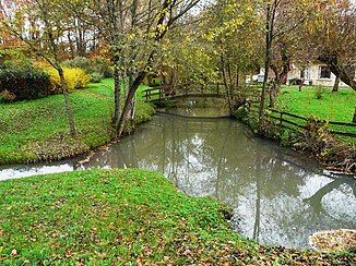
The Varaignes near Varaignes , seen from the D 90 |
||
| Data | ||
| Water code | FR : R1150540 | |
| location | France , Nouvelle-Aquitaine region | |
| River system | Charente | |
| Drain over | Bandiat → Tardoire → Bonnieure → Charente → Atlantic Ocean | |
| source | in the municipality of Saint-Estèphe 45 ° 38 ′ 7 ″ N , 0 ° 39 ′ 8 ″ E |
|
| Source height | approx. 259 m | |
| muzzle | at Varaignes in the Bandiat coordinates: 45 ° 35 ′ 16 ″ N , 0 ° 31 ′ 6 ″ E 45 ° 35 ′ 16 ″ N , 0 ° 31 ′ 6 ″ E |
|
| Mouth height | approx. 116 m | |
| Height difference | approx. 143 m | |
| Bottom slope | approx. 10 ‰ | |
| length | 14 km | |
| Right tributaries | Le Pontet | |
|
The Varaignes at the bridge of the D 75 |
||
The Varaignes , more precisely Ruisseau de Varaignes , alternatively also Ruisseau de Crochet or Ruisseau de l'Étang d'Assat , is a small river in southwest France that runs in the Nouvelle-Aquitaine region . It rises in the municipality of Saint-Estèphe and flows 14 kilometers as a right tributary into the Bandiat . Its average gradient is 10.66 m / km.
Crossed department and place on the river
The Varaignes only crosses the Dordogne department , the only larger town on the river is Varaignes .
Crossed communities
The following municipalities are crossed or touched by the Varaignes:
- Saint-Estèphe (source)
- Bussière-Badil
- Etouars
- Teyjat
- Soudat
- Varaignes (estuary)
Geographical course
The Varaignes rises at an altitude of 259 meters as Ruisseau de l'Étang d'Assat near Puycharnaud in the north of the municipality of Saint-Estèphe, Dordogne - about 4.5 kilometers from the center. Its general direction of discharge is to the west-south-west (N 063 and N 243). Its first three kilometers consist of a sequence of dammed ponds. About 1.5 kilometers south of Soudat it takes up the 3.4 kilometer long Ruisseau du Pontet as a right tributary and from this point on is called Ruisseau de Crochet . From Varaignes it then bears its real name. About 1.5 kilometers southwest of Varaignes it flows into the Bandiat as a right tributary at 116 meters above sea level.
Its total length is 13.5 kilometers.
geology
The source of the Varaignes is located on the Piégut-Pluviers-Granodiorit , more precisely on its coarse-grained porphyry facies. The river then reaches the fine-grained roof facies of the granodiorite and its normal facies. It forms the border between the municipalities of Bussière-Badil and Saint-Estèphe and between Bussière-Badil and Étouars. After crossing a north-north-east-south-south-west trending fault near the hamlet of Chanedière , the river cuts through gneiss of the lower gneiss cover of the Limousin. This is initially plagioclase-bearing paragneiss and then metatexite . In the metatexites, the river forms the municipal boundary between Soudat and Teyjat. Shortly before the confluence on the right-hand side of the Ruisseau du Pontet, it finally reaches flat-lying sediments - the lias of the Aquitaine Basin consisting of arcs, dolomites, oolite limestone as well as gray clays and marls. About a kilometer below the confluence, the river meets the sediments of the Doggers ( Bajocium ), which it follows to the confluence with the Bandiat. The Bajocium is composed primarily of gray limestone , which contains brown ooids. However, it can also occur strongly recrystallized, for example southwest of the hamlet of Lagrelière or at the center of Varaignes, where a south-east-north-west trending fault zone from Javerlhac-et-la-Chapelle-Saint-Robert crosses. The fault is mineralized with lead, zinc and barium and has also recrystallized the Great Dane limestone. Shortly before the confluence with the Bandiat, there are red-brown, fluvial sands and pebbles from the Pleistocene in the Bandiat plain, which have built a middle gravel terrace here.
If the river has cut up to 80 meters deep in the gneisses opposite the basement plateau , its valley widens when it reaches the Liass sediments north of Lauterie . From here to the mouth, Holocene alluvium has accumulated in the valley floor , which consists of fine sands containing quartz and limestone.
Tributaries
The only major tributary is the 3.4 kilometer long Ruisseau du Pontet, which comes from the right towards Soudat . This in turn splits into two side arms 1.2 and 1.1 kilometers in length. In the Dogger, two dry valleys are also worth mentioning, one on the right that flows into La Basse Côte and one on the left that follows the fault zone and enters opposite the center of Varaignes.
literature
- Le Pochat, G. et al.: Carte géologique de la France à 1/50 000. Feuille Montbron . BRGM, 1986.

