
Varnhorn / Siedenbögen
|
Varnhorn / Siedenbögen
Visbek municipality
Coordinates: 52 ° 51 ′ 44 ″ N , 8 ° 19 ′ 29 ″ E
|
|
|---|---|
| Height : | 52-25 m above sea level NN |
| Residents : | 320 (Aug 24, 2018) |
| Postal code : | 49429 |
| Area code : | 04445 |


Varnhorn / Siedenbögen is a peasantry and the northernmost part of the municipality of Visbek in the southern Oldenburg district of Vechta in Lower Saxony . The farming community consists of the village of Varnhorn, three kilometers north-northeast of the Visbeck town center, along with the hamlet of Siedenbögen on the Twillbäke with the (formerly aristocratic) estate Bullmühle and the single farmstead Hubertusmühle. The image of the peasantry is determined by half-timbered farms with old oak trees. In addition to the generally predominant agriculture and livestock farming in Varnhorn, the Siedenbögen district has a forest restaurant with a mill pond, a forwarding agency, a roofing company, a fish farm with a smokehouse and restaurant, a water mill with holiday apartments and a riding and pony farm. The village of Varnhorn itself is about 48 m above sea level. NN . The lowest point (25 m above sea level) Varnhorn is at the same time the lowest and northernmost point of the Visbeck municipality and is located on the sand-shaped Aue lowland stream , north of the Mühlenhöhe corridor .
The A1 runs northwest about three kilometers away. The western local border of the farmers runs mainly along the loess-loam-shaped lowland stream Twillbäke , a tributary of the floodplain, while the floodplain itself represents the northern border of the village. To the east, Varnhorn borders on the area of the town of Wildeshausen (district of Thölstedt farmers ), and to the south on the Visbeck farmers' association Hogenbögen . There the border is formed by the Langenesch watercourse flowing towards the Twillbäke , which runs south of and parallel to the L873 state road about three quarters of a kilometer away.
The parts of the farming community through which the Twillbäke and Aue flow are located in the Bäken nature reserve of the Endeler and Holzhauser Heide .
To the name of the peasantry should be noted that Varnhorn the Farnthorpe the Wildeshauser may correspond foundation document of 872, while Siedenbögen in the 11th century. As Nordbaginny was mentioned.
Since spring 2014, Varnhorn / Siedenbögen has been in the regional public interest due to the planning of an industrial area in the area of the peasantry and the protests and resistance of the residents against it that have continued since then.
administration
District leader of the farmers is Georg Hermes jr. (As of February 13, 2020)
Attractions
In the forest north of Varnhorn in the direction of the Aue there are two Neolithic tombs, the Schmeersteine large stone grave and the Mühlensteine large stone grave . Both come from the Neolithic beaker culture (3500–2800 BC).
A side note in history is the overnight stay of Emperor Napoleon I in a sheepfold built in Varnhorn in 1811. The emperor is said to have spent the night there on one of his campaigns in the so-called French period (1811-1813) - during which Visbek belonged to the French Hanseatic Département de l'Ems-Supérieur (department of the Upper Ems) - because of a wheel damage to his carriage . The Varnhorn local coat of arms, which depicts a sheepfold, also refers to this episode. However, there is no guarantee that this was actually the case.

Large stone grave "Schmeersteine" in Varnhorn

Large stone grave "Schmeersteine" in Varnhorn

Large stone grave "Mühlensteine" in Varnhorn

Large stone grave "Mühlensteine" in Varnhorn
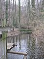
Weir at the Bullmühle in Siedenbögen

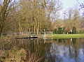
Mill pond at the Bullmühle in Siedenbögen
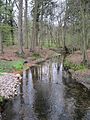
Twillbäke above the Bullmühle in Siedenbögen
Twillbäke below the Hubertusmühle in Siedenbögen


Web links
- Navigator focused on the farmers of Varnhorn / Siedenbögen interactively. Official map service of the LGLN
- The Varnhorn / Siedenbögen farmers' association on the Visbek community website
Individual evidence
- ↑ Clemens Pagenstert: The farms in the office of Vechta http://digital.lb-oldenburg.de/ihd/content/pageview/353183 , Koch: Vechta, 1908. S. 214.
- ↑ Landkarte Ortschaftsgrenzen_50000.pdf, publisher: Municipality of Visbek, Office for Building, Planning and Environmental Matters, Rathausplatz 1, 49429 Visbek
- ↑ Nature reserve "Bäken der Endeler und Holzhauser Heide" at the Lower Saxony State Office for Water Management, Coastal Protection and Nature Protection
- ↑ Library of Princeton University The Architectural and Artistic Monuments of the Duchy of Oldenburg, 1896/1900, Volume II, Amt Vechta, p. 377/197 /, Grand Ducal State Ministry, accessed on February 13, 2020.
- ^ District newspaper Syke from March 12, 2014 - demo against industrial area , accessed on January 4, 2015.
- ↑ https://www.visbek.de/gemeinde Gemeinde Visbek, Die Gemeinde, Bezirksvorsteher
- ↑ Stonepages: Schmeersteine. Varnhorn Sprockhoff No. 977 ( Memento of the original from January 11, 2008 in the Internet Archive ) Info: The archive link was inserted automatically and has not yet been checked. Please check the original and archive link according to the instructions and then remove this notice.
- ↑ Stonepages: Millstones. VarnhornSprockhoff No. 976 ( Memento of the original from January 11, 2008 in the Internet Archive ) Info: The archive link was inserted automatically and has not yet been checked. Please check the original and archive link according to the instructions and then remove this notice.
- ↑ Visbek municipality. Varnhorn sheepfold . Retrieved November 28, 2013.
- ↑ Visbek municipality. History / Chronicle . Retrieved October 11, 2013.

Astrup | Receipt rights | Endel | Erlte | Hagstedt | Halter / Meyerhöfen | Hogen bows | North Döllen | Right field | Varnhorn / Siedenbögen | Visbek | Wöstendöllen