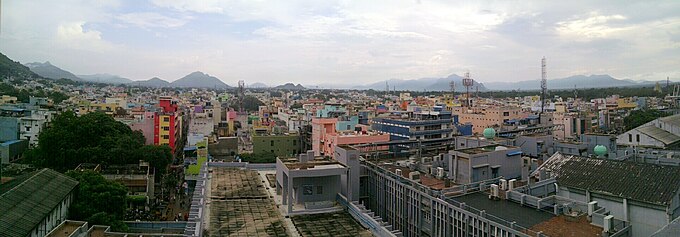
Vellore
| Vellore வேலூர் |
||
|---|---|---|
|
|
||
| State : |
|
|
| State : | Tamil Nadu | |
| District : | Vellore | |
| Location : | 12 ° 55 ' N , 79 ° 8' E | |
| Height : | 216 m | |
| Area : | 87.9 km² | |
| Residents : | 185,803 (2011) | |
| Population density : | 2114 inhabitants / km² | |
| Website : | Vellore | |
| Vellore - moats | ||
Vellore ( Tamil : வேலூர் Vēlūr ) is a city with around 190,000 inhabitants in the southern Indian state of Tamil Nadu . It is the administrative seat of the district of Vellore .
location
Vellore extends on both banks of the Palar River about 140 km (driving distance) west of Chennai (formerly Madras ) at an altitude of about 220 m above sea level. d. M. The climate is hot and quite rainy in the second half of the year.
population
Approx. 70% of the inhabitants of Vellore are Hindus , approx. 24% are Muslims and just under 5% are Christians ; Vellore has been the seat of a Catholic diocese since 1953 . A little more than 1% is accounted for by the religious communities of Buddhists , Jains and Sikhs . The proportion of women in the population is slightly higher than that of men. As in all of Tamil Nadu, the main language is Tamil, which is spoken by 71% of the population as their mother tongue; 21% speak Urdu and 6% Telugu , but Hindi and English are also understood and spoken by most city dwellers.
economy
For centuries, the production and processing of leather has provided the economic basis for life in the city. Today Vellore is best known for its hospital, the Christian Medical College (CMC), which is considered one of the largest and best equipped in India, and for the private university Vellore Institute of Technology (VIT). There are also several University of Chennai-affiliated colleges in the city.
history
In the Middle Ages, Vellore was under the rule of the Pallava , Rashtrakuta , Chola and the Vijayanagar Empire . After its disintegration as a result of the Battle of Talikota in 1565, the Nayaks , the former provincial governors of Vijayanagars, rose to become regional rulers. Vellore also came under the control of a nayak who, in the second half of the 16th century, ordered the construction of a strong fortress to defend the city. Around the middle of the 17th century, the fortress fell into the hands of the Sultan of Bijapur , whose troops were driven out by the Marathas as early as 1676 . She was followed in 1708 by Daud Khan, the first nawab of Arcot . He and his successors were able to hold Vellore until 1760, when the British first advanced into the city. A few years later the fortress was taken over by the Muslim general Hyder Ali , who had headed the kingdom of Mysore in 1761 . For Hyder Ali and his successor Tipu Sultan , it represented an important bulwark against the British adversaries. The latter, however, managed to keep the city occupied between 1780 and 1782, during the Second Mysore War . After the final defeat of Mysore in 1799, Tipu Sultan's children were held captive by the British in the Vellore fortress.
Vellore became famous for a revolt by Indian mercenaries against their British commanders on May 10, 1806, which went down in history as Vellore Munity . At that time, insurgent soldiers stormed the Vellore fortress to free the children of Tipu Sultan. British troops, however, bloodily crushed the mutiny within a few hours.
Attractions
- The main attraction of the city is the 16th century fortress surrounded by a moat.
- The Jalagandeswarar temple in the area of the fort dates from the time of the Vijayanagar rule over the city. Its four gateways ( gopurams ) tower far beyond the actual temple, which is located within a walled temple area. Like most of the sculptures of the era, those of the Jalagandeswarar temple are not without a certain rudeness.
- The Assumption Cathedral , built at the end of the 20th century, is a central building with numerous gable windows and a central cone.
Surroundings
- Approx. The Sri Lakshmi Narayani Golden Temple, inaugurated in 2007, is located 8 km southwest of the town of Sripuram - within a star-shaped outer wall .
Web links
- Vellore, Sripuram, Golden Temple - Photos + Info (English)
- Vellore, Sripuram, Sect - Photos + Info (English)
- Vellore map with elevation information


