Viernheim Cross
| Viernheim Cross | |
|---|---|
|
|
|
| map | |
| location | |
| Country: | Germany |
| State : | Hesse |
| Coordinates: | 49 ° 31 '23 " N , 8 ° 33' 36" E |
| Height: | 94 m above sea level NN |
| Basic data | |
| Design type: | Shamrock |
| Bridges: | 1 (motorway) / 1 (other) |
| Construction year: | 1968 |
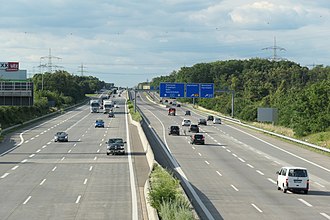
| A 6, Viernheimer Kreuz, direction north | |
The Viernheimer Kreuz is a motorway junction that lies directly on the border between the state of Hesse and Baden-Württemberg . It is located in the Rhine-Neckar metropolitan region . Here the federal highway 6 ( Saarbrücken - Mannheim - Nuremberg , Europastraße 50 ) crosses the federal highway 659 ( Viernheim - Weinheim ), which becomes the federal highway 38 in the direction of Mannheim .
geography
The Viernheimer Kreuz is located on the northeastern edge of the city of Mannheim in the area of the city of Viernheim (Hesse) and borders directly on Baden-Württemberg.
The Viernheimer Kreuz is the connection from Mannheim to the Rhine-Main area via the federal motorway 67 (via A 6 ) as well as (via the Weinheim motorway junction ) to the A 5 , which is about 5.5 km further east roughly parallel to the A 6 runs.
It is number 4 on the A 659 and number 26 on the A 6.
State of development
The A 6 has six lanes in this area, the A 659 (coming from Mannheim) has six lanes as far as the Viernheimer Kreuz, then four lanes. All transitions are single-lane.
The cross is laid out in the shape of a clover.
Traffic volume
The Viernheimer Kreuz is passed by around 150,000 vehicles every day.
| From | To | Average daily traffic volume |
Share of heavy goods traffic |
||||
|---|---|---|---|---|---|---|---|
| 2005 | 2010 | 2015 | 2005 | 2010 | 2015 | ||
| AD Viernheim (A 6) | AK Viernheim | 69,900 | 71,500 | 86,300 | 12.5% | 13.8% | 13.2% |
| AK Viernheim | AK Mannheim (A 6) | 68,600 | 70,900 | 99,900 | 10.4% | 12.1% | 12.2% |
| AS Viernheim (A 659) | AK Viernheim | 62,800 | 55,200 | 61,500 | 17.4% | 5.1% | 5.3% |
| AK Viernheim | End of motorway (B 38) | 52,300 | 36,400 | 53,200 | 2.6% | 4.0% | 5.2% |
Web links
Individual evidence
- ↑ Manual road traffic census 2005. (PDF) Results on federal motorways. BASt Statistics, 2005, accessed on October 27, 2019 .
- ↑ Manual road traffic census 2010. (PDF) Results on federal motorways. BASt Statistics, 2010, accessed on October 27, 2019 .
- ↑ Manual road traffic census 2015. (PDF) Results on federal motorways. BASt Statistics, 2015, accessed on August 22, 2017 .

