Weisbach (Remptendorf)
|
Weisbach
community Remptendorf
|
|
|---|---|
| Coordinates: 50 ° 33 ′ 33 ″ N , 11 ° 35 ′ 57 ″ E | |
| Height : | 518 m above sea level NN |
| Area : | 5.84 km² |
| Residents : | 186 (December 31, 2009) |
| Population density : | 32 inhabitants / km² |
| Incorporation : | July 1, 1999 |
| Postal code : | 07368 |
| Area code : | 036643 |
|
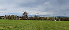
View from the south of the place
|
|
Weisbach is a small village in the middle of the Thuringian Slate Mountains with 186 inhabitants (as of 2009) and is part of the municipality of Remptendorf in the Saale-Orla district .
geography
The village is on the eastern edge of a plateau, away from all major roads. Not far away is the former Triptis – Marxgrün railway with the Ziemestal bridge . The Hohenwarte reservoir extends to the north . The area of the municipality is designated with 584 ha.
history
The place was first mentioned in a document in 1347. It was probably founded as a street village in the second half of the 12th century as part of the state development by the Lords of Lobdeburg . The bailiffs of Gera took over the rule of Weisbach from the lords of Lobdeburg zu Saalburg around the middle of the 13th century . Because the small tower hill castle of the Lobdeburgers on the south-eastern outskirts no longer seemed sufficient as a border fortress against the Schwarzburger , the bailiffs built a new hilltop castle, the Wysburg , on the castle hill two kilometers away in the last decades before 1300 . This was probably destroyed in the Vogtland War in autumn 1354 by a contingent of the imperial cities of Erfurt, Mühlhausen and Nordhausen.
Until 1920 Weisbach was divided between the Reuss and the Schwarzburgers . The Schwarzburg part formed an exclave that belonged to the Leutenberg area of the sovereignty of the principality or Free State of Schwarzburg-Rudolstadt (from 1850 to the district office of Rudolstadt ). The Russian part belonged to the "Herrschaft Lobenstein" ( Reuss-Lobenstein line ). In 1848 this came to the Principality of Reuss Younger Line (from 1852 to the Schleiz District Office ) and in 1919 to the People's State of Reuss .
During the time of the GDR, Weisbach belonged to the Lobenstein district in the Gera district . After 1990, it was a member of the Saale-Sormitz-Höhen administrative community until it was incorporated into the district reform in Thuringia on July 1, 1999. Since then, it has been a part of the Remptendorf community.
Population development
Development of the population (as of December 31st)
|
|
coat of arms
Weisbach's coat of arms shows a green tree on a green background, the trunk of the tree is brown and the background is light blue.
museum
In 1989, a permanent exhibition was opened in Weisbach in the Wysburg House. The finds recovered during the archaeological excavations are shown (ceramic vessels and iron utensils). The original appearance of the castle is explained using maps and models.
Individual evidence
- ^ The District Office Rudolstadt in the municipality register 1900
- ^ Johann Ernst Fabri : Geography for all estates. Part 1, Volume 4: Which contains the continuation and the resolution of the Upper Saxon Circle. Schwickert, Leipzig 1793, p. 881 .
- ^ The Schleiz district office in the municipality register 1900
- ↑ StBA: Changes in the municipalities in Germany, see 1999
- ^ Thuringian State Office for Statistics


