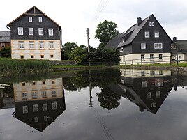
Thierbach (Remptendorf)
|
Thierbach
community Remptendorf
Coordinates: 50 ° 29 ′ 49 ″ N , 11 ° 33 ′ 7 ″ E
|
||
|---|---|---|
| Height : | 560 (540-583) m above sea level NN | |
| Area : | 4.22 km² | |
| Residents : | 119 (March 20, 2015) | |
| Population density : | 28 inhabitants / km² | |
| Incorporation : | July 1, 1999 | |
| Postal code : | 07368 | |
| Area code : | 036652 | |
|
Location of Thierbach in Thuringia |
||
|
In the town
|
||
Thierbach has been part of the municipality of Remptendorf in the Saale-Orla district in Thuringia since 1999 .
geography
The corridor of the village is located on a high plateau of the southeast Thuringian slate mountains, which is mostly inclined to the west . The slopes that fall after the Sormitztal and the hills around the district mostly bear forest.
From the constantly rising road L2377 from the Sormitztal a local road leads to the village. The connection to the federal highway 90 is given via the L 2377 . Neighboring places are south Klettigshammer and Eliasbrunn, west Heberndorf , north Neumühle and east Ruppersdorf .
history
Thierbach was first mentioned in a document in 1509. Agriculture and forestry shaped and shaped the place: farmers of the place joined the peasant army in Neustadt an der Orla in the Peasants' War on April 27, 1525.
During the Catholic period, Thierbach belonged to the large parish of Gahma. The deceased Thierbachers were also buried there at that time. Since the introduction of Lutheran teaching in this area in 1543, Thierbach has been part of the church in Ruppersdorf, where the dead were buried until the Thierbach cemetery was established in 1927. In 1567 there is a report for the first time about a manorial sheep farm in Thierbach. In 1841, a school was built in Thierbach for 41 students from that time. In 1906, after two years of construction, a new school was built, which is still the focus of the town today.
The place belonged to the Reussian "Herrschaft Lobenstein ", which belonged to the Reuss-Lobenstein line . In 1848 the place came to the Principality of Reuss Younger Line (from 1852 to the Schleiz District Office ) and in 1919 to the People's State of Reuss . The place has belonged to Thuringia since 1920.
In 1930 the first and so far only stone-age pointed hoe of the “Vogtland type” in the Lobensteiner area, with an estimated age of around 7,000 years, was found during cultivation in the field “Henkersfleck”. In 1969 a poultry farm was built in the village, which is still in operation today. Since 1987 the old tradition of sheep farming has been carried out in the partly remaining buildings of the former chamber estate. There has also been a roofing shop in the village since 1992, which employs 12 journeymen.
coat of arms
The coat of arms shows a brown doe by a stream in the foreground (blue, wavy); Wetzstein, Kulm and Henneberg are shown in green in the background. They stand out sharply against the blue of the sky.
Web links
Individual evidence
- ^ Saale-Sormitz-Kurier Official & Bulletin
- ^ Georg Brückner : Regional and Folklore of the Principality of Reuss j. L. Part 2: Local history of the Principality of Reuss j. L. Koehler, Gera et al. 1870, pp. 752-753 .
- ^ Johann Ernst Fabri : Geography for all estates. Part 1, Volume 4: Which contains the continuation and the resolution of the Upper Saxon Circle. Schwickert, Leipzig 1793, p. 881 .
- ^ The Schleiz district office in the municipality register 1900

