
Porta Westfalica (Weser breakthrough)

The Porta Westfalica (also Westfälische Pforte , popularly simply Porta or Weserscharte ) is the breakthrough of the Weser between Wiehengebirge and Wesergebirge in the north-eastern part of North Rhine-Westphalia , the region of Ostwestfalen-Lippe ( Germany ).
In the breakthrough, the river Weser coming from the south leaves the Weser Uplands and flows north into the North German Plain . It was designated as a National Geotope in 2006 .
Geographical location
Porta Westfalica is located in the Minden-Lübbecke district in the triangle of the cities of Porta Westfalica in the southeast, Bad Oeynhausen in the southwest and Minden in the north. With the river Weser it separates the Wiehengebirge in the west from the Wesergebirge in the east and the Upper Weser Valley (Oberweser) in the south from the Middle Weser Valley (Mittelweser) in the north. The Weser breakthrough is surrounded on both sides by the eastern part of the Northern Teutoburg Forest-Wiehengebirge Nature Park . In the south is the Great Weserbogen .
On the eastern slope of the Wittekindsberg , the easternmost mountain of the Wiehengebirge, stands the Kaiser Wilhelm monument . Opposite the Jakobsberg , the westernmost mountain in the Weser Mountains, is the Jakobsberg telecommunications tower with a viewing platform.
Transport links

The federal highways 61 , 65 and 482 intersect at Porta Westfalica, which provide a connection to the federal highways 2 and 30, which run not far to the south, and to the road system of the surrounding towns.
The Federal Highway 61 and federal highway 428 extend approximately in the north-south direction parallel to the Weser by the Porta Westfalica. A bridge over the Weser connects them south of the gate near the town of Porta Westfalica, roughly in a west-east direction. The B 65 crosses the Weser north of the gate near Minden over the Theodor-Heuss-Brücke . The B 61 leads through the 1,730 meter long Weserauentunnel , which runs parallel to the Weser and bypasses the Barkhausen district east of the Wittekindsberg .
The Hamm – Minden railway line also runs through the Porta Westfalica in a south-south-west-north-northeast direction and parallel to the Weser. The Porta Westfalica station on this railway line , which belongs to the town of the same name and is located on the eastern bank of the Weser at the west foot of the Jakobsberg, provides a connection to the Deutsche Bahn network .
In addition, Porta Westfalica can be reached via the Porta Westfalica airport located near Porta Westfalica- Vennebeck .
Not far north of Porta Westfalica, the Mittelland Canal crosses the Weser at the Minden waterway junction , so that there is a waterway connection between the Ems in the west and the Elbe in the east.
There are also hiking trails through the Porta Westfalica breakthrough in the Weser, including the European long-distance hiking trail 11 .
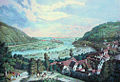
Historical view around 1840

View from the north to Porta Westfalica

View from the south to Porta Westfalica

The Porta Westfalica around 1900 with still existing, flat mountain slopes; they were later dismantled for roads


.jpg)
literature
- Horst Mensching (editor): The landscape at the Porta Westfalica - a geographical excursion guide (= yearbook of the Geographical Society of Hanover 1971). Hanover 1971.
- Franz-Dieter Miotke: The landscape at the Porta Westfalica. Part I: The natural landscape (= yearbook of the Geographical Society of Hanover 1968). Hanover 1968.
- Sebastian Schröder: The Porta Westfalica . In: Westphalian places of memory. Contributions to the collective memory of a region. Edited by Lena Krull. Schöningh, Paderborn 2017, ISBN 978-3-506-78607-4 , pp. 143–155.
Web links
Individual evidence
- ↑ Die Landschaft , accessed on February 5, 2016, at portawestfalica.de
Coordinates: 52 ° 14 ′ 38.4 " N , 8 ° 55 ′ 10.6" E