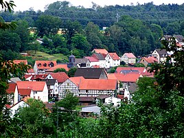
Wiera (Schwalmstadt)
|
Wiera
City of Schwalmstadt
Coordinates: 50 ° 52 ′ 54 ″ N , 9 ° 8 ′ 19 ″ E
|
|
|---|---|
| Height : | 225 m above sea level NHN |
| Area : | 9.49 km² |
| Residents : | 642 (December 31, 2018) |
| Population density : | 68 inhabitants / km² |
| Incorporation : | December 31, 1971 |
| Postal code : | 34613 |
| Area code : | 06692 |
|
Wiera
|
|
Wiera is a district of the city of Schwalmstadt in the Schwalm-Eder district of Hesse .
Geographical location
The place is about three kilometers southwest of Treysa on the Schwalm tributary of the same name, the Wiera . The section of the federal highway 454 between Treysa and Neustadt , from which the roads to Momberg and Mengsberg branch off , runs through Wiera . In addition, Wiera has a train station on the Main-Weser-Bahn , which is served by the Mittelhessen-Express on the Treysa- Frankfurt line , as well as the RE line 98 on the Kassel - Frankfurt / Main route.
history
To the south-east of the village lies the barrow of Wiera , an archaeological site from the Middle Bronze Age . The place Wiera was first mentioned in 1197 as Wirahin in a document of the Spieskappel monastery .
Wiera has been part of Schwalmstadt since December 31, 1971.
politics
The local advisory council has seven members (SPD: 4; CDU: 3). The mayor has been Helmut Daub (SPD) since 2001.
Cultural monuments
For the cultural monuments of the place see the list of cultural monuments in Wiera (Schwalmstadt) .
The evangelical branch church was built in 1828. It is a classicist , three-axis hall church in exposed stone masonry with a hipped roof . Inside there is a three-sided gallery and an altar and a pulpit behind it from the construction period. The organ dates from around 1900.
Individual evidence
- ↑ Numbers / data / facts. In: website. City of Schwalmstadt, accessed August 2020 .
- ↑ Population figures on December 31, 2018. In: website. City of Schwalmstadt, accessed August 2020 .
- ^ Wiera (Kirchwiera, Oberwiera), Schwalm-Eder district. Historical local dictionary for Hessen. (As of August 11, 2014). In: Landesgeschichtliches Informationssystem Hessen (LAGIS).
- ^ Federal Statistical Office (ed.): Historical municipality directory for the Federal Republic of Germany. Name, border and key number changes in municipalities, counties and administrative districts from May 27, 1970 to December 31, 1982 . W. Kohlhammer GmbH, Stuttgart / Mainz 1983, ISBN 3-17-003263-1 , p. 412 .
- ↑ Brigitte Warlich-Schenk: Monument topography "Schwalm-Eder-Kreis I" . with the assistance of Hans Josef Böker. Ed .: State Office for Monument Preservation Hesse (= architectural monuments in Hesse ). Friedr. Vieweg & Sohn, Braunschweig 1985, ISBN 3-528-06233-9 , pp. 422-423 .
Web links
- Wiera district. In: Website of the city of Schwalmstadt.
- Wiera (Kirchwiera, Oberwiera), Schwalm-Eder district. Historical local dictionary for Hessen. In: Landesgeschichtliches Informationssystem Hessen (LAGIS).
- Literature about Wiera in the Hessian Bibliography


