
Woodstock, Ontario
| Woodstock | |||
|---|---|---|---|
 Main street Dundas Street |
|||
| Motto : The Friendly City | |||
| Location in Ontario | |||
|
|||
| State : |
|
||
| Province : | Ontario | ||
| Region : | Oxford County | ||
| Coordinates : | 43 ° 8 ′ N , 80 ° 45 ′ W | ||
| Height : | 300 m | ||
| Area : | 49 km² | ||
| Residents : | 37,754 (as of 2011) | ||
| Population density : | 770.5 inhabitants / km² | ||
| Time zone : | Eastern Time ( UTC − 5 ) | ||
| Postal code : | N4S, N4T, N4V | ||
| Area code : | +1 519 and 226 | ||
| Website : | www.city.woodstock.on.ca | ||

Woodstock is a city of 38,000 people in the south-west of the Canadian province of Ontario . It is located about 140 km southwest of Toronto , 45 km east of London (Ontario) and 70 km north of Lake Erie . The city of Woodstock is the center of the agricultural sector of Oxford County and its administrative center.
The main route from Toronto to the border crossings in the USA between Windsor and Detroit , Highway 401 opens up Woodstock with four exits to the south. This is also where Highway 403 branches off to the east, an alternative highway in the direction of the greater Toronto area with a branch in Hamilton to the border crossings over the Niagara River .
Woodstock is extensively surrounded by agricultural land, mostly arable land. The formerly predominant dairy industry in the surrounding area led to the name Capital of the Canadian Dairy Industry ( Dairy Capital of Canada ). Woodstock is now characterized by light industry and services and is called The Friendly City
history
The first settlements can be identified around 1800. Fifty years later there were about 1,000 residents and by 1900 Woodstock had 9,000 residents. In the old town center with its rectangular street network there are still remarkable remnants of Victorian architecture , including the market building, courthouse, town hall and former prison, as well as several streets with spacious, partly park-like town houses of the time. Since it was founded, Woodstock has been crisscrossed by a wide and dead straight main street, Dundas Street . In the meantime, the former focus of commercial life there has almost completely shifted to newly developed areas on the outskirts. A few banks, authorities, restaurants and small shops are still left.
economy
The largest employer in Woodstock is the car manufacturer Toyota, which has a large assembly plant for the North American market. Toyota employs around 2,400 people at this facility. Other commercial settlements include automotive suppliers, transport companies, distribution centers (including General Motors' main spare parts warehouse for Canada ) and various companies in the light industry and construction industry. The large-scale industrial parks are mostly on both sides of the motorway and on Dundas Street on the eastern edge of the city .
Intensive arable farming is practiced in the vast surrounding area. Large farms that mainly grow maize and various types of beans are predominant. In between there are occasional dairy cattle, pigs or poultry farms. With the exception of a feed mill on the railway line, there are hardly any traces of the former dominance of this economic sector in the city. Immediately on the northwestern outskirts of Woodstock, a major agricultural exhibition takes place every September, the Canada Outdoor Farm Show .
Parks and recreation
On the northern outskirts of the city, an approximately 500 m wide and 5 km long reservoir, the Pittock Reservoir , was built to regulate the flood of the Thames River . The parts of the bank suitable for swimming are fenced and accessible for an entrance fee. If there is a summer water shortage, the water can be polluted and is then blocked for bathing. The outflow from this reservoir meanders on the western edge of the city through a seldom encountered alluvial forest, which is freely accessible as a park, but where the municipal sewage treatment plant is also located.
The Southside Park is the largest urban open spaces with large duck pond, recreation and picnic area. Also to the south is an event center with multiple halls, the Woodstock District Community Complex . There are several golf courses on the outskirts and in the surrounding area, which is common for this region. On the arterial road to the north, on Highway 59, there is a sports field with soccer fields and building complex, which is operated by the Woodstock Soccer Club .
climate
The continental climate is characterized by snowy winters with long periods of frost and relatively warm, sometimes humid summer months, so air conditioning in buildings is standard. Since the surrounding agricultural land is largely drained , heavy rain can lead to sudden floods. Long periods of drought can also occur in summer. The climate, in connection with the soil conditions, favors the occurrence of mosquitoes, so that windows in residential buildings are always equipped with mosquito screens. The temperature differences compared to the Great Lakes, which are relatively cool in summer , often lead to steady winds during the day and calm in the late afternoon hours.
|
Woodstock climate data (1971-2000)
|
||||||||||||||||||||||||||||||||||||||||||||||||||||||||||||||||||||||||||||||||||||||||||
Public facilities and transport
As a local center there are a large number of public schools, churches and authorities. In the south of the city, near the motorway, a hospital was opened in 2011, which can cover a population of around 55,000 people.
A city bus network serves as a public transport system within the city. There are no bike paths. In general, cycling is unusual - except for sports purposes. There is also a VIA Rail Canada train station on the Toronto-Windsor route, which only offers a few connections per day. Long-distance public transport, especially to Toronto Airport , which is 125 km away , is practically only covered by private bus routes.
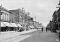
Dundas Street around 1913

former prison, now health department

Market hall built in 1900
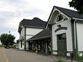
railway station

Court established in 1892


sons and daughters of the town
- Harold Fraser (1872-1945), American golfer
Distances to other places
| Stratford (40 km), Grand Bend on Lake Huron (100 km) | Owen Sound (180 km) on Georgian Bay ( Huron Sea ) | Kitchener (50 km), Toronto Airport (125 km), Toronto (140 km) |
| London (45 km), Sarnia - border crossing USA (155 km) |
.svg)
|
Brantford (40 km), Hamilton (80 km), Niagara Falls - border crossing USA (150 km) |
| Windsor - border crossing USA (235 km) | Tillsonburg (40 km), Port Burwell on Lake Erie (70 km) | Simcoe (60 km), Port Dover on Lake Erie (75 km) |
Web links
- official Woodstock website
- official Woodstock website for business and location marketing
- Spatial data service for Woodstock and Oxford Counties
- current weather Woodstock
- Citizens' initiative to preserve public green spaces
- Oxford Historical Society
- Local Woodstock Sentinel Review
Individual evidence
- ↑ Statistics Canada - Census 2011 - Woodstock, Ontario , accessed April 25, 2013.
- ↑ Toyota car factory in Woodstock ( Memento of the original from May 4, 2013 in the Internet Archive ) Info: The archive link was automatically inserted and not yet checked. Please check the original and archive link according to the instructions and then remove this notice.
- ↑ General Motors main spare parts warehouse for Canada ( Memento of the original from January 16, 2013 in the Internet Archive ) Info: The archive link has been inserted automatically and has not yet been checked. Please check the original and archive link according to the instructions and then remove this notice.
- ^ Canada Outdoor Farm Show
- ↑ Leisure facility at Pittock Reservoir