
Jervis Inlet: Difference between revisions
→History: add ref for native name\ |
m v2.05b - Bot T20 CW#61 - Fix errors for CW project (Reference before punctuation) |
||
| (30 intermediate revisions by 21 users not shown) | |||
| Line 1: | Line 1: | ||
{{Short description|Inlet in British Columbia, Canada}} |
|||
{{Infobox body of water |
{{Infobox body of water |
||
| name |
| name = Jervis Inlet |
||
| |
| other_name = {{lang-fr|Baie Jervis}} |
||
| image = MtFWAir.jpg |
|||
| ⚫ | |||
| image_size = 260px |
|||
| image_bathymetry = |
|||
|pushpin_map=British Columbia |
|||
| caption_bathymetry = |
|||
| ⚫ | |||
| location = |
|||
| image_bathymetry = Carte simplifiée baie Jervis.svg |
|||
| coords = {{Coord|49|59|47.73|N|123|58|6.53|W}} |
|||
| ⚫ | |||
| ⚫ | |||
| location = [[British Columbia]], [[Canada]] |
|||
| ⚫ | |||
| coords = {{coord|49|55|25|N|123|58|27|W|region:CA-BC_type:waterbody_source:http://www4.rncan.gc.ca/search-place-names/unique/JARXV|name=Jervis Inlet|display=title,inline}} |
|||
| ⚫ | |||
| ⚫ | |||
| ⚫ | |||
| part_of = [[Salish Sea]] |
|||
| ⚫ | |||
| ⚫ | |||
| length_km = 89 |
|||
| ⚫ | |||
| width = |
|||
| ⚫ | |||
| area = |
|||
| ⚫ | |||
| depth = |
|||
| length = {{convert|89|km|abbr=on}}<ref name=GoC>{{Cite web|last=Government of Canada|first=Fisheries and Oceans|date=2009-01-29|title=Fisheries and Oceans Canada {{!}}Pacific Region {{!}} Jervis Inlet|url=https://www.pac.dfo-mpo.gc.ca/science/oceans/BCinlets/jervis-eng.htm|access-date=2020-10-03|website=www.pac.dfo-mpo.gc.ca}}</ref> |
|||
| max-depth_m = 670 |
|||
| width = |
|||
| ⚫ | |||
| area = |
|||
| ⚫ | |||
| depth = |
|||
| shore = |
|||
| max-depth = {{convert|670|m|abbr=on}}<ref name=GoC/> |
|||
| ⚫ | |||
| ⚫ | |||
| ⚫ | |||
| ⚫ | |||
| ⚫ | |||
| shore = |
|||
| ⚫ | |||
| ⚫ | |||
| ⚫ | |||
}} |
}} |
||
'''Jervis Inlet'''<ref>{{Cite cgndb|JARXV|Jervis Inlet|2020-06-16}}</ref> ({{IPAc-en|local|ˈ|dʒ|ɑːr|v|ɪ|s}} {{respell|JAR|viss}})<ref>{{Citation| author = The Canadian Press| author-link = The Canadian Press| title = The Canadian Press Stylebook| place = Toronto| publisher = [[The Canadian Press]]| edition = 18th| year = 2017}}</ref> (''lekw'emin'' in [[Shíshálh language|she shashishalhlem]])<ref>{{Cite web |date=2023-01-03 |title=lekw’emin |url=https://apps.gov.bc.ca/pub/bcgnws/names/74767.html |website=BC Geographical Names}}</ref> is one of the principal inlets of the [[British Columbia Coast]], about {{convert|95|km|abbr=on}} northwest of [[Vancouver]], and the third of such inlets north of the [[49th parallel north|49th parallel]], the first of which is [[Burrard Inlet]], Vancouver's harbour.<ref>{{BCGNIS|10102|Jervis Inlet}}</ref><ref>{{Cite web |date=2024-01-03 |title=lekw'emin |url=https://apps.gov.bc.ca/pub/bcgnws/names/74767.html |website=BC Geographical Names}}</ref> |
|||
'''Jervis Inlet''' {{IPAc-en|local|ˈ|dʒ|ɑr|v|ɨ|s}} is a principal inlet of the [[British Columbia Coast]], about {{convert|95|km|abbr=on}} northwest of [[Vancouver]].<ref>{{BCGNIS|10102|Jervis Inlet}}</ref> |
|||
==Geography== |
==Geography== |
||
It stretches {{convert| |
It stretches {{convert|89|km|abbr=on}} from its head at the mouth of the short ({{convert|18|km|abbr=on|disp=or}}) [[Skwawka River]] to its opening into the [[Strait of Georgia]] near [[Texada Island]]. It is the deepest fjord on the British Columbia coast with a maximum depth of {{convert|670|m|abbr=on}}.<ref name=GoC/> |
||
The inlet is made up of three arms or reaches: |
The inlet is made up of three arms or reaches: |
||
| Line 35: | Line 40: | ||
* [[Queens Reach]] |
* [[Queens Reach]] |
||
At its uppermost stretch is Queens Reach, which takes a sharp right-angle often seen in [[fjord]] areas, to become |
At its uppermost stretch is Queens Reach, which takes a sharp right-angle often seen in [[fjord]] areas, to become Princess Royal Reach. Both reaches are about {{convert|20|km|abbr=on}} in length. The flanks of the fjord and the valley of the [[Skwawka River]], which feeds the head of the inlet, are the site of two of Canada's highest waterfalls, [[James Bruce Falls]] ({{convert|840|m|abbr=on|disp=or}}) and [[Alfred Creek|Alfred Creek Falls]] at {{convert|700|m|abbr=on}}. |
||
The most frequented and best known inlet in the area is [[Princess Louisa Inlet]], with the [[Malibu |
The most frequented and best known inlet in the area is [[Princess Louisa Inlet]], with the [[Malibu, British Columbia|Malibu Club]] and [[Young Life]] Camp at the [[Malibu Rapids]], the entrance of the inlet, and [[Princess Louisa Marine Provincial Park]], including [[Chatterbox Falls]], at its head. |
||
At the mouth of Jervis Inlet a passenger and vehicle ferry operated by [[BC Ferries]] connects [[ |
At the mouth of Jervis Inlet a passenger and vehicle ferry operated by [[BC Ferries]] connects [[Earls Cove, British Columbia|Earls Cove]] (on the upper end of the [[Sechelt Peninsula]] and lower [[Sunshine Coast (British Columbia)|Sunshine Coast]]) with [[Saltery Bay Provincial Park|Saltery Bay]] (on the bottom end of the [[Malaspina Peninsula]] and upper Sunshine Coast). |
||
The mouth of [[Sechelt Inlet]] connects with Jervis Inlet in the area of |
The mouth of [[Sechelt Inlet]] connects with lekw’emin (Jervis Inlet) in the area of sḵelh (Earls Cove).<ref>{{Cite web |date=2023-01-03 |title=sḵelh |url=https://apps.gov.bc.ca/pub/bcgnws/names/74769.html |website=BC Geographical Names}}</ref> |
||
Population is sparse on the shores of |
Population is sparse on the shores of lekw’emin and there is no road access to the area. Industry includes small operations in aquaculture, commercial fishing and logging, but a substantial number of independent power projects are expected to develop in coming years{{when|date=June 2020}}. |
||
===Climate=== |
===Climate=== |
||
{{Weather box |
{{Weather box |
||
| location |
| location = Jervis Inlet |
||
| metric first = yes |
| metric first = yes |
||
| single line |
| single line = yes |
||
| Jan record high C = 14 |
| Jan record high C = 14 |
||
| Feb record high C = 12.5 |
| Feb record high C = 12.5 |
||
| Line 102: | Line 107: | ||
| Dec record low C = -13.5 |
| Dec record low C = -13.5 |
||
| year record low C = -13.5 |
| year record low C = -13.5 |
||
|precipitation colour = green |
|||
| Jan precipitation mm = 279.5 |
| Jan precipitation mm = 279.5 |
||
| Feb precipitation mm = 252.8 |
| Feb precipitation mm = 252.8 |
||
| Line 116: | Line 122: | ||
| year precipitation mm = 2445.5 |
| year precipitation mm = 2445.5 |
||
| source 1 = [[Environment Canada]]<ref name="climate">[[Environment Canada]]—[http://climate.weatheroffice.gc.ca/climate_normals/results_e.html?Province=BC%20%20&StationName=&SearchType=&LocateBy=Province&Proximity=25&ProximityFrom=City&StationNumber=&IDType=MSC&CityName=&ParkName=&LatitudeDegrees=&LatitudeMinutes=&LongitudeDegrees=&LongitudeMinutes=&NormalsClass=A&SelNormals=&StnId=319& Climate Normals 1971–2000], accessed 25 March 2010</ref> |
| source 1 = [[Environment Canada]]<ref name="climate">[[Environment Canada]]—[http://climate.weatheroffice.gc.ca/climate_normals/results_e.html?Province=BC%20%20&StationName=&SearchType=&LocateBy=Province&Proximity=25&ProximityFrom=City&StationNumber=&IDType=MSC&CityName=&ParkName=&LatitudeDegrees=&LatitudeMinutes=&LongitudeDegrees=&LongitudeMinutes=&NormalsClass=A&SelNormals=&StnId=319& Climate Normals 1971–2000], accessed 25 March 2010</ref> |
||
| date |
| date = August 2010 |
||
}} |
}} |
||
==History== |
==History== |
||
Prior to colonization, two of the four primary sub-groups of [[Shíshálh Nation|shíshálh]] People had principal settlements in lekw’emin. The head of lek’wemin was the primary village site of the x̱enichen people.<ref>{{Cite web |date=2023-01-03 |title=lil x̱emit tems swiya nelh mes stutula: A Strategic Land Use Plan for the shíshálh Nation |url=https://shishalh.com/wp-content/uploads/2018/10/SLUP.pdf |website=shíshálh Nation}}</ref> The name x̱enichen roughly means “go to the end until you can’t go any further” referring to the northern extent of the shíshálh "swiya", or territory.<ref>{{Cite web |date=2023-01-03 |title=x̱enichen |url=https://apps.gov.bc.ca/pub/bcgnws/names/75699.html |website=BC Geographical Names}}</ref> The ts’unay people had their principal village site at ts’unay (Deserted Bay)<ref>{{Cite web |date=2023-01-03 |title=ts’unay |url=https://apps.gov.bc.ca/pub/bcgnws/names/75740.html |website=BC Geographical Names}}</ref> located approximately 20km south of x̱enichen. |
|||
The head of Jervis Inlet was once a seasonal settlement of the Sechelt Indian Band, who called it ''xénichen'' (often anglicized as Hunaechin).<ref>[http://www.secheltnation.ca/ Sechelt Nation website Territory Description page]</ref> |
|||
[[George Vancouver]] named the inlet after the [[Vancouver Expedition| |
[[George Vancouver]] named the inlet after the [[Vancouver Expedition|1791–1795 expedition]] to search for the fabled [[Northwest Passage]]. In the [[Royal Navy]] tradition, Vancouver named this main waterway after his friend [[John Jervis, 1st Earl of St Vincent|Rear Admiral Sir John Jervis (Earl of St. Vincent)]] for his [[Battle of Cape St Vincent (1797)|victory over the Spanish fleet]] on February 14, 1797 at [[Cape St. Vincent]] in Portugal.<ref>{{cite bcgnis|10102|Jervis Inlet}}</ref> He named St. Vincent's Bay (near the entrance of Jervis Inlet) after the location of the battle, St. Vincent Bay.<ref name=hitz>Hitz, Charles W.(2003).''Through the Rapids - The History of Princess Louisa Inlet'', p.30. [http://www.sitka2.com Sitka 2 Publishing] {{webarchive|url=https://web.archive.org/web/20081122034513/http://www.sitka2.com/ |date=2008-11-22 }}., Kirkland, Washington. {{ISBN|0-9720255-0-2}}.</ref> |
||
| ⚫ | The three specific reaches of the inlet and mountains were named in the 1860 survey by |
||
| ⚫ | The three specific reaches of the inlet and mountains were named in the 1860 survey by {{HMS|Plumper|1848|6}}, which charted the known area in honour of members of Queen Victoria's family.<ref name=hitz/> The waterways named during this survey mission were: [[Princess Louisa Inlet]], [[Queens Reach]], [[Princess Royal Reach]], and [[Prince of Wales Reach]]. Also named were the main mountains of the area: |
||
*[[Mount Alfred]] |
*[[Mount Alfred]] |
||
*[[Mount |
*[[Mount Frederick William]] |
||
*[[Mount Arthur |
*[[Mount Arthur (British Columbia)|Mount Arthur]] |
||
*[[Mount Wellington |
*[[Mount Wellington (British Columbia)|Mount Wellington]] |
||
*[[Mount Alice (British Columbia)|Mount Alice]] |
*[[Mount Alice (British Columbia)|Mount Alice]] |
||
*[[ |
*[[Ḵ'els|ḵ’els (Mount Victoria)]] |
||
*[[Mount Helena |
*[[Mount Helena (British Columbia)|Mount Helena]] |
||
*[[Mount Albert |
*[[Mount Albert (Canada)|Mount Albert]] |
||
In the early 1900s, logging and commercial fishing developed in the Jervis Inlet area. Relatively large logging camps operated at Goliath Bay, Vancouver Bay and Hotham Sound, commercial fishing was conducted by owner-operators based in Egmont, [[Pender Harbour]] and Saltery Bay, and several fish-processing plants operated in Egmont, |
In the early 1900s, logging and commercial fishing developed in the lekw’emin (Jervis Inlet) area. Relatively large logging camps operated at Goliath Bay, Vancouver Bay and Hotham Sound, commercial fishing was conducted by owner-operators based in Egmont, [[Pender Harbour|ḵalpilin (Pender Harbour)]] and sḵelhp (Saltery Bay),<ref>{{Cite web |date=2023-01-03 |title=sḵelhp |url=https://apps.gov.bc.ca/pub/bcgnws/names/73763.html |website=BC Geographical Names}}</ref> and several fish-processing plants operated in Egmont, ḵalpilin and sḵelhp. |
||
==Gallery== |
==Gallery== |
||
<gallery |
<gallery> |
||
File:Jervis.JPG|A [[sailboat]] explores [[Princess Royal Reach]] of the |
File:Jervis.JPG|A [[sailboat]] explores [[Princess Royal Reach]] of the lekw’emin. |
||
File:MtArt.JPG|[[Mount Arthur (British Columbia)|Mount Arthur]] |
File:MtArt.JPG|[[Mount Arthur (British Columbia)|Mount Arthur]] and [[Mount Frederick William]] from the entrance of the [[Princess Louisa Inlet]]. |
||
File:Dusk.jpg| |
File:Dusk.jpg|lekw’emin at dusk. |
||
File:MtAlfred.JPG|[[Mount Alfred]] seen from the inlet. |
File:MtAlfred.JPG|[[Mount Alfred]] seen from the inlet. |
||
File:Alfred.JPG|[[Mount Alfred]] from a logging road along the inlet. |
File:Alfred.JPG|[[Mount Alfred]] from a logging road along the inlet. |
||
File:Mt Arthur.JPG|[[Mount Arthur (British Columbia)|Mount Arthur]] rising above |
File:Mt Arthur.JPG|[[Mount Arthur (British Columbia)|Mount Arthur]] rising above lekw’emin |
||
& [[Malibu Club]]. |
|||
| ⚫ | |||
</gallery> |
</gallery> |
||
| Line 154: | Line 157: | ||
==External links== |
==External links== |
||
{{Commons category}} |
|||
*[http://www.pac.dfo-mpo.gc.ca/sci/osap/projects/bcinlets/Jervis_Inlet_e.htm Deep Water Properties of Jervis Inlet] Department of Fisheries and Oceans. |
*[http://www.pac.dfo-mpo.gc.ca/sci/osap/projects/bcinlets/Jervis_Inlet_e.htm Deep Water Properties of Jervis Inlet] Department of Fisheries and Oceans. |
||
*[http://www.bcarchives.gov.bc.ca/cartogr/img_html/dir_1/cm_c2308.htm CM_C2308 Fraser River to N.E.Pt. of Texada Island including Howe Sound and Jervis Inlet 'Annotated' 1863.02.16 1865.08] |
*[https://web.archive.org/web/20080616084659/http://www.bcarchives.gov.bc.ca/cartogr/img_html/dir_1/cm_c2308.htm CM_C2308 Fraser River to N.E.Pt. of Texada Island including Howe Sound and Jervis Inlet 'Annotated' 1863.02.16 1865.08]{{Clarify|ambiguous site|date=December 2017}} |
||
{{Coord|49|59|47.73|N|123|58|6.53|W|display=title}} |
|||
{{British Columbia hydrography}} |
{{British Columbia hydrography}} |
||
Latest revision as of 05:05, 9 January 2024
| Jervis Inlet | |
|---|---|
| French: Baie Jervis | |
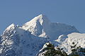
 Mount Frederick William & the "elbow" of the inlet | |
 Jervis Inlet | |
 Map of Jervis Inlet | |
| Location | British Columbia, Canada |
| Coordinates | 49°55′25″N 123°58′27″W / 49.92361°N 123.97417°W |
| Type | Fjord |
| Part of | Salish Sea |
| Max. length | 89 km (55 mi)[1] |
| Max. depth | 670 m (2,200 ft)[1] |
Jervis Inlet[2] (locally /ˈdʒɑːrvɪs/ JAR-viss)[3] (lekw'emin in she shashishalhlem)[4] is one of the principal inlets of the British Columbia Coast, about 95 km (59 mi) northwest of Vancouver, and the third of such inlets north of the 49th parallel, the first of which is Burrard Inlet, Vancouver's harbour.[5][6]
Geography[edit]
It stretches 89 km (55 mi) from its head at the mouth of the short (18 km or 11 mi) Skwawka River to its opening into the Strait of Georgia near Texada Island. It is the deepest fjord on the British Columbia coast with a maximum depth of 670 m (2,200 ft).[1]
The inlet is made up of three arms or reaches:
At its uppermost stretch is Queens Reach, which takes a sharp right-angle often seen in fjord areas, to become Princess Royal Reach. Both reaches are about 20 km (12 mi) in length. The flanks of the fjord and the valley of the Skwawka River, which feeds the head of the inlet, are the site of two of Canada's highest waterfalls, James Bruce Falls (840 m or 2,760 ft) and Alfred Creek Falls at 700 m (2,300 ft).
The most frequented and best known inlet in the area is Princess Louisa Inlet, with the Malibu Club and Young Life Camp at the Malibu Rapids, the entrance of the inlet, and Princess Louisa Marine Provincial Park, including Chatterbox Falls, at its head.
At the mouth of Jervis Inlet a passenger and vehicle ferry operated by BC Ferries connects Earls Cove (on the upper end of the Sechelt Peninsula and lower Sunshine Coast) with Saltery Bay (on the bottom end of the Malaspina Peninsula and upper Sunshine Coast).
The mouth of Sechelt Inlet connects with lekw’emin (Jervis Inlet) in the area of sḵelh (Earls Cove).[7]
Population is sparse on the shores of lekw’emin and there is no road access to the area. Industry includes small operations in aquaculture, commercial fishing and logging, but a substantial number of independent power projects are expected to develop in coming years[when?].
Climate[edit]
| Climate data for Jervis Inlet | |||||||||||||
|---|---|---|---|---|---|---|---|---|---|---|---|---|---|
| Month | Jan | Feb | Mar | Apr | May | Jun | Jul | Aug | Sep | Oct | Nov | Dec | Year |
| Record high °C (°F) | 14 (57) |
12.5 (54.5) |
17.5 (63.5) |
26.5 (79.7) |
32.5 (90.5) |
32 (90) |
32 (90) |
35 (95) |
30.5 (86.9) |
23 (73) |
16.5 (61.7) |
12.5 (54.5) |
35 (95) |
| Mean daily maximum °C (°F) | 4.2 (39.6) |
5.8 (42.4) |
8.8 (47.8) |
12.9 (55.2) |
16.8 (62.2) |
19.7 (67.5) |
22.6 (72.7) |
22.8 (73.0) |
18.7 (65.7) |
12.3 (54.1) |
6.8 (44.2) |
4.1 (39.4) |
13 (55) |
| Mean daily minimum °C (°F) | 1.1 (34.0) |
1.8 (35.2) |
3.2 (37.8) |
5.6 (42.1) |
8.9 (48.0) |
12 (54) |
14.4 (57.9) |
15.1 (59.2) |
11.9 (53.4) |
7.8 (46.0) |
3.5 (38.3) |
1.2 (34.2) |
7.2 (45.0) |
| Record low °C (°F) | −7.5 (18.5) |
−11 (12) |
−3.9 (25.0) |
0 (32) |
2.5 (36.5) |
5.6 (42.1) |
8 (46) |
9.4 (48.9) |
5 (41) |
−4 (25) |
−10 (14) |
−13.5 (7.7) |
−13.5 (7.7) |
| Average precipitation mm (inches) | 279.5 (11.00) |
252.8 (9.95) |
216.9 (8.54) |
165.4 (6.51) |
141.6 (5.57) |
123.3 (4.85) |
94.1 (3.70) |
96.8 (3.81) |
109.8 (4.32) |
282 (11.1) |
372.3 (14.66) |
311.1 (12.25) |
2,445.5 (96.28) |
| Source: Environment Canada[8] | |||||||||||||
History[edit]
Prior to colonization, two of the four primary sub-groups of shíshálh People had principal settlements in lekw’emin. The head of lek’wemin was the primary village site of the x̱enichen people.[9] The name x̱enichen roughly means “go to the end until you can’t go any further” referring to the northern extent of the shíshálh "swiya", or territory.[10] The ts’unay people had their principal village site at ts’unay (Deserted Bay)[11] located approximately 20km south of x̱enichen.
George Vancouver named the inlet after the 1791–1795 expedition to search for the fabled Northwest Passage. In the Royal Navy tradition, Vancouver named this main waterway after his friend Rear Admiral Sir John Jervis (Earl of St. Vincent) for his victory over the Spanish fleet on February 14, 1797 at Cape St. Vincent in Portugal.[12] He named St. Vincent's Bay (near the entrance of Jervis Inlet) after the location of the battle, St. Vincent Bay.[13]
The three specific reaches of the inlet and mountains were named in the 1860 survey by HMS Plumper, which charted the known area in honour of members of Queen Victoria's family.[13] The waterways named during this survey mission were: Princess Louisa Inlet, Queens Reach, Princess Royal Reach, and Prince of Wales Reach. Also named were the main mountains of the area:
- Mount Alfred
- Mount Frederick William
- Mount Arthur
- Mount Wellington
- Mount Alice
- ḵ’els (Mount Victoria)
- Mount Helena
- Mount Albert
In the early 1900s, logging and commercial fishing developed in the lekw’emin (Jervis Inlet) area. Relatively large logging camps operated at Goliath Bay, Vancouver Bay and Hotham Sound, commercial fishing was conducted by owner-operators based in Egmont, ḵalpilin (Pender Harbour) and sḵelhp (Saltery Bay),[14] and several fish-processing plants operated in Egmont, ḵalpilin and sḵelhp.
Gallery[edit]
-
 A sailboat explores Princess Royal Reach of the lekw’emin.
 -

-
 lekw’emin at dusk.
 -
 Mount Alfred seen from the inlet.
 -
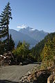 Mount Alfred from a logging road along the inlet.
 -
 Mount Arthur rising above lekw’emin


References[edit]
- ^ a b c Government of Canada, Fisheries and Oceans (2009-01-29). "Fisheries and Oceans Canada |Pacific Region | Jervis Inlet". www.pac.dfo-mpo.gc.ca. Retrieved 2020-10-03.
- ^ "Jervis Inlet". Geographical Names Data Base. Natural Resources Canada. Retrieved 2020-06-16.
- ^ The Canadian Press (2017), The Canadian Press Stylebook (18th ed.), Toronto: The Canadian Press
- ^ "lekw'emin". BC Geographical Names. 2023-01-03.
- ^ "Jervis Inlet". BC Geographical Names.
- ^ "lekw'emin". BC Geographical Names. 2024-01-03.
- ^ "sḵelh". BC Geographical Names. 2023-01-03.
- ^ Environment Canada—Climate Normals 1971–2000, accessed 25 March 2010
- ^ "lil x̱emit tems swiya nelh mes stutula: A Strategic Land Use Plan for the shíshálh Nation" (PDF). shíshálh Nation. 2023-01-03.
- ^ "x̱enichen". BC Geographical Names. 2023-01-03.
- ^ "ts'unay". BC Geographical Names. 2023-01-03.
- ^ "Jervis Inlet". BC Geographical Names.
- ^ a b Hitz, Charles W.(2003).Through the Rapids - The History of Princess Louisa Inlet, p.30. Sitka 2 Publishing Archived 2008-11-22 at the Wayback Machine., Kirkland, Washington. ISBN 0-9720255-0-2.
- ^ "sḵelhp". BC Geographical Names. 2023-01-03.