Mratín: Difference between revisions
Content deleted Content added
population |
mNo edit summary |
||
| Line 56: | Line 56: | ||
==History== |
==History== |
||
{{stack|[[File:Mratín, Saint Michael church.jpg|thumb| |
{{stack|[[File:Mratín, Saint Michael church.jpg|thumb|160px|Church of [[Saint Michael]]]]}} |
||
The first written mention about Mratín is from 1372.<ref>{{cite web |title=O obci|url=https://www.mratin.cz/o%2Dobci/ds-50/p1=52|publisher=Obec Mratín|language=cs|accessdate=2020-11-05}}</ref> |
The first written mention about Mratín is from 1372.<ref>{{cite web |title=O obci|url=https://www.mratin.cz/o%2Dobci/ds-50/p1=52|publisher=Obec Mratín|language=cs|accessdate=2020-11-05}}</ref> |
||
Revision as of 16:58, 19 June 2021
Mratín | |
|---|---|
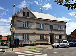
 Municipal office | |
| Coordinates: 50°12′11″N 14°33′4″E / 50.20306°N 14.55111°E | |
| Country | |
| Region | Central Bohemian |
| District | Prague-East |
| First mentioned | 1372 |
| Area | |
| • Total | 4.90 km2 (1.89 sq mi) |
| Elevation | 192 m (630 ft) |
| Population (2021-01-01)[1] | |
| • Total | 1,404 |
| • Density | 290/km2 (740/sq mi) |
| Time zone | UTC+1 (CET) |
| • Summer (DST) | UTC+2 (CEST) |
| Postal code | 250 63 |
| Website | www |
Mratín is a municipality and village in Prague-East District in the Central Bohemian Region of the Czech Republic. It has about 1,400 inhabitants.
History

The first written mention about Mratín is from 1372.[2]
References
- ^ "Population of Municipalities – 1 January 2021". Czech Statistical Office. 2021-04-30.
- ^ "O obci" (in Czech). Obec Mratín. Retrieved 2020-11-05.
External links
- Official website (in Czech)
- Information portal (in Czech)
Wikimedia Commons has media related to Mratín.


