Úvaly
| Úvaly | ||||
|---|---|---|---|---|
|
||||
| Basic data | ||||
| State : |
|
|||
| Region : | Středočeský kraj | |||
| District : | Praha-východ | |||
| Area : | 1096 ha | |||
| Geographic location : | 50 ° 4 ' N , 14 ° 44' E | |||
| Height: | 253 m nm | |||
| Residents : | 6,744 (Jan 1, 2019) | |||
| Postal code : | 250 82 | |||
| traffic | ||||
| Railway connection: | Prague - Kolín | |||
| structure | ||||
| Status: | city | |||
| Districts: | 1 | |||
| administration | ||||
| Mayor : | Ivan Černý (as of 2006) | |||
| Address: | Pražská 276 250 82 Úvaly |
|||
| Municipality number: | 538957 | |||
| Website : | www.mestouvaly.cz | |||
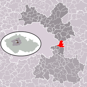
| Location of Úvaly in the Praha-východ district | ||||

|
||||
Úvaly (German Auwal , older also accident or accident ) is a town with 5191 inhabitants in the Czech Republic . It is located 23 kilometers east of Prague city center on the outskirts of Prague and belongs to the Okres Praha-východ . The cadastral area is 1096 ha.
geography
Úvaly is located on the southeast edge of the Klánovický les ( Fiederholz ) at 253 m above sea level. M. at the Výmola river . The railway runs through the city from Prague to Český Brod and the state road Silnice I / 12 , which also connects these cities and crosses in Úvaly with the state road 101 from Říčany to the D11 motorway and to Brandýs nad Labem-Stará Boleslav .
The Výmola and its tributaries Přišimaský potok and Škvorecký potok feed the ponds Lhoták, Fabrák, Mlýnský rybník and the drained Hodovský rybník. To the west of the city are the remains of Skara Castle.
Neighboring towns are Nové Jirny and Horoušánky in the north, Tlustovousy in the northeast, Tuklaty and Rostoklaty in the east, Límuzy and Přišimasy in the southeast, Škvorec in the south, Dobročovice and Květnice in the southwest and the Prague districts Újezd nad Lesy in the west.
history
The first written mention of Úvaly comes from 1290. From 1300 the place owned by Prague patricians was called a market. Úvaly belonged partly to the Škvorec lordship , which in 1361 the Prague patrician Velflín Menhart Olbramovič acquired. This line of the Wolfram ( Olbramovici ) family, originally from Eger , was named after their seat from Škvorec. The Prague Archbishop Olbram of Škvorec comes from here . Due to over-indebtedness, the Škvorec family had to cede the Škvorec rule to their creditors in 1418, and Jan z Klučova became the new owner. After further sales, Jan Čeněk z Klinštejna acquired the rule in 1462.
The other part of Úvaly was held by the Hostyně family, and in 1560 it was also acquired by the Smiřický family from Smiřice .
The place that Václav Hájek z Libočan still referred to as a market town in 1541 had become insignificant due to the damage of the Thirty Years War and was only referred to as a submissive town in 1654. After the lords of Klinštejn the lords of Stěžov followed, from 1532 the Smiřický of Smiřice as owners. After their extinction, the property fell to Albrecht von Waldstein , who sold the Škvorec, Kostelec and Uhříněves domains to Karl von Liechtenstein . Until the replacement of patrimonial rule in 1850, the Liechtenstein owners of Úvaly remained and also held extensive land holdings until the 20th century.
In 1754 a post office was set up and in 1854 the area was given a post office. In 1835 Úvaly was raised to a market town again. In 1844, under the direction of Jan Perner, construction began on the Prague - Olomouc railway line , on which the first train rolled through Auwal on August 20, 1845. A 135 m long viaduct was built over the Výmola.
In the middle of the 19th century, iron ore mining started and eight shafts were sunk in the Na Ouvaláku corridor. Later a brick factory and the sugar factory were built. In 1921 the spelling of the place name was changed from Ouvaly to Úvaly. Úvaly has had city rights since 1969.
Attractions
- The Church of the Annunciation was built on the site of a chapel consecrated in 1342 by Ernst von Pardubitz . It received its baroque appearance during the renovation in 1742.
- Statue of St. John of Nepomuk, erected in 1701
- Statue of Ernst von Pardubitz from 1869
- The 135 m long railway viaduct Devět kanálů was built in 1844
- Rectory, built in 1856
- School, neo-renaissance building from 1911 to 1912
- Manor from the 1st half of the 17th century
Fixed hostyně
Hostín farm is located in the southern Slovany district between Přišimaský potok and the road to Škvorec . The former fortress of Hostyně, of which historical masonry and underground passages are still preserved, is said to be the birthplace of Ernst von Pardubitz . The facility is not accessible, the yard serves as a car recycling and collection point for secondary raw materials.
sons and daughters of the town
- Marie Majerová (1882–1967), Czech writer, born in Úvaly
Web links
Footnotes
- ↑ Český statistický úřad - The population of the Czech municipalities as of January 1, 2019 (PDF; 7.4 MiB)
- ↑ http://biblio.unibe.ch/adam/zoom/zoom.php?col=ryh&pic=Ryh_4403_1_B
- ↑ http://cuni.georeferencer.com/map/a0aPBdTFmkhGesLlLD6Qbf/201506151920-zGm2Ug/visualize
- ↑ There are no contemporary sources on his place of birth. In addition to the fortress Hostyně, more recent sources mention: Glatz , where his father was lord of the castle around 1300, Hostinka in East Bohemia, where a Verste was located that was in the possession of his ancestors, and Staré Hrady near Jitschin , which is known to have belonged to around 1340 Family was. Information from: Jaroslav Polc: Ernst vom Pardubitz . In: Ferdinand Seibt, Life Pictures for the History of the Bohemian Countries , Vol. 3, 1978, p. 26.


