Strančice
| Strančice | ||||
|---|---|---|---|---|
|
||||
| Basic data | ||||
| State : |
|
|||
| Region : | Středočeský kraj | |||
| District : | Praha-východ | |||
| Area : | 1161 ha | |||
| Geographic location : | 49 ° 57 ' N , 14 ° 41' E | |||
| Height: | 415 m nm | |||
| Residents : | 2,469 (Jan 1, 2019) | |||
| Postal code : | 251 63 | |||
| License plate : | S. | |||
| traffic | ||||
| Railway connection: | České Velenice – Prague | |||
| structure | ||||
| Status: | local community | |||
| Districts: | 7th | |||
| administration | ||||
| Mayor : | Jiří Šindelář (as of 2017) | |||
| Address: | Revoluční 383 251 63 Strančice |
|||
| Municipality number: | 538809 | |||
| Website : | www.strancice.org | |||
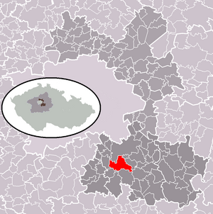
| Location of Strančice in the Praha-východ district | ||||

|
||||
Strančice is a municipality in the Czech Republic . It is located 26 kilometers southeast of the city center of Prague and belongs to the Okres Praha-východ .
history
The first written mention of Strančice comes from 1404.
The place only became more important in 1868, when the construction of the railroad began in the municipality. In 1871 the railway was opened with a journey from Čerčany to Prague.
Community structure
Strančice consists of the districts Kašovice , Otice , Předboř , Sklenka , Strančice , Svojšovice and Všechromy .
Attractions
- former synagogue
- Chapel of St. Anna
- Church of St. Nicholas in Otice
Economy and Infrastructure
The administration building of the concrete plant BETON Strančice sro received the Czech Architecture Prize in 2018 .
Sons and daughters of the church
- Emil Kolben (1862–1943), electrical engineering pioneer and entrepreneur
Web links
Commons : Strančice - collection of pictures, videos and audio files


