
Bořanovice
| Bořanovice | |||||
|---|---|---|---|---|---|
|
|||||
| Basic data | |||||
| State : |
|
||||
| Region : | Středočeský kraj | ||||
| District : | Praha-východ | ||||
| Area : | 535 ha | ||||
| Geographic location : | 50 ° 11 ' N , 14 ° 29' E | ||||
| Height: | 249 m nm | ||||
| Residents : | 860 (Jan. 1, 2019) | ||||
| Postal code : | 250 65 | ||||
| License plate : | S. | ||||
| traffic | |||||
| Street: | Líbeznice - Prague | ||||
| Next international airport : | Prague airport | ||||
| structure | |||||
| Status: | local community | ||||
| Districts: | 2 | ||||
| administration | |||||
| Mayor : | Jaroslav Kolín (as of 2008) | ||||
| Address: | Ke Kampeličce 67 250 65 Líbeznice |
||||
| Municipality number: | 538086 | ||||
| Website : | www.boranovice.cz | ||||
| Location of Bořanovice in the Praha-východ district | |||||

|
|||||


Bořanovice (German Borschanowitz ) is a municipality in the Czech Republic . It is located twelve kilometers north of the city center of Prague on the city limits and belongs to the Okres Praha-východ .
geography

Bořanovice is located on the Bohemian Table in the basin of the Líbeznický potok. The D 8 / E 55 motorway runs west of the village . There is also exit 1 "Zdiby". State road 9 leads north from Líbeznice to the motorway.
Neighboring towns are Bašť in the north, Líbeznice in the northeast, Hovorčovice in the east, Třeboradice in the southeast, Březiněves in the south, Dolní Chabry and Zdiby in the southwest, Zdibsko and Klecany in the west and Sedlec in the northwest.
history
The first written mention of Bořanovice comes from a Přemysl Otakars I dated 1227 , in which the village was given to the nunnery of St. George on Hradschin . This document was created as a subsequent forgery by the monastery to prove ownership. Bořanovice remained monastic property until the 16th century. From 1576 the Bořanovský von Bytíška are documented as owners. This family, originally from Moravia , named themselves after the village.
In 1609 Rudolf von Lidlov bought the property. He was in debt and had to pledge Bořanovice to Zdeňek Smolík von Slavice. Its property left behind was confiscated in 1622 after the Battle of White Mountain . According to the wish of Abbess Sophie Albin von Helfenburg, Bořanovice was inherited in 1663 and attached to the monastic estates in Panenské Břežany . After the abolition of the monastery as part of the Josephine reforms, the Bořanovice farm was parceled out in 1782. Until 1848 Bořanovice remained subject to the rule Panenské Břežany.
After the abolition of patrimonial Bořanovice and Pakoměřice were districts of the Sedlec municipality in the Karlín district. In 1922 the village of Bořanovice was established, to which the Pakoměřice district has belonged ever since. From 1928 the municipality belonged to the Praha-venkov district, from 1946 to Okres Praha-sever and since 1961 to Okres Praha-východ. Bořanovice has had a coat of arms since 1998. The Bořanovice district today consists of 118 houses, in Pakoměřice there are 131.
Community structure
The municipality Bořanovice consists of the districts Bořanovice ( Borschanowitz ) and Pakoměřice ( Pakomierschitz ). Both parts have grown together to form a closed development area.
Attractions
- Pakoměřice Castle, the four-wing building was built from a fortress in the 17th century. It was the headquarters of the Nostitz-Rieneck family until the Měšice Castle was built .
- Church of the Virgin Mary's Cradle Festival in Pakoměřice, the originally Gothic building that has been documented since 1352, was redesigned in Baroque style in the second half of the 18th century.
- Mortuary, from the second half of the 18th century, with a baroque fresco "Crucifixion of Christ"
- Remnants of the brewery
- Rectory, from the end of the 18th century
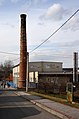
Remnants of the brewery

Pakoměřice Castle

