Totten Key: Difference between revisions
Content deleted Content added
m added Robert E. Lee on survey |
m →References: copyedit,refine category structure, general fixes using AWB using AWB |
||
| Line 19: | Line 19: | ||
[[Category:Uninhabited islands of Miami-Dade County, Florida]] |
[[Category:Uninhabited islands of Miami-Dade County, Florida]] |
||
[[Category:Biscayne National Park]] |
[[Category:Biscayne National Park]] |
||
[[Category:Islands of Florida]] |
|||
Revision as of 07:07, 25 December 2015

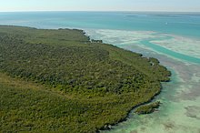
Totten Key is an island of the upper Florida Keys in Biscayne National Park. It is in Miami-Dade County, Florida.
It is located in southern Biscayne Bay, just west of Old Rhodes Key.
History
It was probably named for General Joseph Totten who was Chief of Engineers for the U.S. Army. In 1848, Totten was in charge of a survey of the Florida coast concentrating on Biscayne Bay, with Robert E. Lee as a subordinate.
U.S. Coast Survey chart #68, Florida Reefs, Key Biscayne to Carysfort Reef (1858) has Totten's Key.[1]
References
25°22′47″N 80°14′54″W / 25.3796°N 80.2484°W
