
Zakopane
Zakopane | |
|---|---|
.JPG) Zakopane - view from Gubałówka Hill (Tatra mountains in the background) | |
 Coat of arms | |
| Country | |
| Voivodeship | Lesser Poland |
| County | Tatra |
| Gmina | Zakopane (urban gmina) |
| Established | 17th century |
| Town rights | 1933 |
| Government | |
| • Mayor | Janusz Majcher |
| Area | |
| • Total | 84 km2 (32 sq mi) |
| Highest elevation | 1,126 m (3,694 ft) |
| Lowest elevation | 750 m (2,460 ft) |
| Population (2006) | |
| • Total | 27,486 |
| • Density | 330/km2 (850/sq mi) |
| Time zone | UTC+1 (CET) |
| • Summer (DST) | UTC+2 (CEST) |
| Postal code | 34-500 to 34-504 |
| Area code | +48 18 |
| Car plates | KTT |
| Website | http://www.zakopane.eu |
Zakopane Template:Audio-IPA-pl is a town in southern Poland with some 28,000 inhabitants (2004), situated in Lesser Poland Province since 1999 (in 1975–98, it was part of Nowy Sącz Province). The town, a place of Góral culture and informally known as "the winter capital of Poland," lies in the southern part of the Podhale region at the foot of the Tatra Mountains, the only alpine mountain range in the Carpathian Mountains.
Location
Zakopane lies in a large valley between the Tatra Mountains and Gubałówka Hill. It is the most important Polish center of mountaineering and skiing, and is visited annually by some three million tourists. The most important alpine skiing locations are Kasprowy Wierch, Nosal and Gubałówka Hill.[1]
Zakopane has the highest elevation (800-1,000 m) of any town in Poland. The central point of the town is at the junction of Krupówki and Kościuszko Streets.
History
The earliest documents mentioning Zakopane date to the 17th century, describing a glade named Zakopisko. In 1676 it was a village of 43 inhabitants. In 1824, together with a section of the Tatra Mountains, it was sold to the Homola family.
Zakopane's further history was connected with the development of the mining and metallurgy industries in the region — in the 19th century, it was the largest center for metallurgy in Galicia — and later with that of tourism. It grew greatly over the 19th century, as more and more people were attracted by its salubrious climate, and soon developed from a small village into a climatic health resort of 3,000 inhabitants (1889).
Rail service to Zakopane began on October 1, 1899.
During World War II, Zakopane served as an important Polish underground staging point between Poland and Hungary.
In March 1940, representatives of the Soviet NKVD and German Gestapo met for one week in Zakopane's Villa Tadeusz, to coordinate the pacification of resistance in Poland.
Sports
Zakopane hosted the Nordic World Ski Championships in 1929, 1939, and 1962; the winter Universiades in 1956, 1993, and 2001; the biathlon World Championship; several ski jumping world cups; and several Nordic combined, Nordic and Alpine European Cups. It hosted the Alpine World Ski Championships in 1939, the first outside the Alps and the last official world championships prior to World War II. [1]
Zakopane recently made unsuccessful bids to host the 2006 Winter Olympics and the [[FIS Alpine World Ski Championships 2011|2011] and 2013 Alpine World Ski Championships.
Twin cities


Notable structures
Notable residents
- Jan Bachleda-Curus, Olympian. The Bachleda and Pawlica families are the two oldest families in Zakopane.
- Tytus Chałubiński physician
- Olga Drahonowska-Małkowska, one of the founders of Scouting movement in Poland
- Władysław Hasior, sculptor
- Jan Kasprowicz, poet, playwright
- Kornel Makuszyński, children's writer
- Jan Marusarz, Olympian
- Stanisław Marusarz, Olympian
- Władysław Orkan
- Jan Pawlica, Olympian
- Karol Szymanowski, composer. His house in Zakopane, the Villa Atma, is now a museum dedicated to the composer.
- Stanisław Witkiewicz
- Stanisław Ignacy Witkiewicz (Witkacy), playwright, novelist, philosopher, photographer and painter
- Mariusz Zaruski mountaineer and yachtsman
- Jerzy Żuławski, poet, writer
Notable visitors
- Mieczysław Karłowicz
- Serge Lifar
- Emil Młynarski
- Bolesław Prus[2]
- Kazimierz Przerwa-Tetmajer
- Artur Rubinstein
- Henryk Sienkiewicz
- Krystyna Skarbek
- Maria Skłodowska-Curie
- Stefan Żeromski[3]
Gallery
-
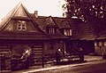 Typical Zakopane house
 -
 Zakopane at night
 -
 Zakopane - Gubałówka Hill ski run
 -
 Zakopane - Gubałówka Hill: a nursery ski run
 -
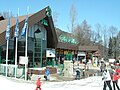 Zakopane - Gubałówka Hill funicular entrance
 -
 Zakopane - Gubałówka Hill funicular
 -
 Aerial view of Zakopane
 -
 Szymanowski Museum at the Villa Atma

.JPG)
.JPG)
.JPG)
.JPG)


Notes
- ^ Seattle Times - Scenic Zakopane
- ^ Krystyna Tokarzówna and Stanisław Fita, Bolesław Prus, 1847–1912: Kalendarz życia i twórczości, pp. 178–79 and passim.
- ^ Stanisław Kasztelowicz and Stanisław Eile, Stefan Żeromski: kalendarz życia i twórczości, p. 18 and passim.
References
- Stanisław Kasztelowicz and Stanisław Eile, Stefan Żeromski: kalendarz życia i twórczości (Stefan Żeromski: A Calendar of His Life and Work), Kraków, Wydawnictwo Literackie, 1961.
- Krystyna Tokarzówna and Stanisław Fita, Bolesław Prus, 1847–1912: Kalendarz życia i twórczości (Bolesław Prus, 1847–1912: A Calendar of His Life and Work), edited by Zygmunt Szweykowski, Warsaw, Państwowy Instytut Wydawniczy, 1969.
External links
- Official Page (Local Municipality)
- Zakopane
- General information, available in Polish, English, German
- Zakopane ICT - Travel Guide
- Symphony No. 3 of Henryk Górecki using text found in a Gestapo cell in Zakopane.
49°18′N 19°58′E / 49.300°N 19.967°E
| Seat |
|  |
|---|---|---|
| Rural gminas | ||