
Polepy (Kolín District)
You can help expand this article with text translated from the corresponding article in Czech. (July 2009) Click [show] for important translation instructions.
|
Polepy (Kolín District) | |
|---|---|
Municipality and village | |
 | |
 Flag _znak.jpg) Coat of arms | |
| Country | |
| Region | Central Bohemian Region |
| District | Kolín District |
| Area | |
| • Total | 0.93 sq mi (2.42 km2) |
| Elevation | 696 ft (212 m) |
| Population (2011) | |
| • Total | 595 |
| • Density | 640/sq mi (250/km2) |
| Time zone | UTC+1 (CET) |
| • Summer (DST) | UTC+2 (CEST) |
Polepy (Kolín District) is a village and municipality in Kolín District in the Central Bohemian Region of the Czech Republic.
Gallery
-
 Middle part
 -
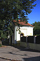 Small chapel
 -
 Restaurant


References
- This article was initially translated from the Czech Wikipedia.
Wikimedia Commons has media related to Polepy.