Mratín: Difference between revisions
Content deleted Content added
population |
population |
||
| (4 intermediate revisions by the same user not shown) | |||
| Line 1: | Line 1: | ||
{{Infobox settlement |
{{Infobox settlement |
||
| name = Mratín |
| name = Mratín |
||
| ⚫ | |||
| other_name = |
| other_name = |
||
| settlement_type = [[Obec|Municipality]] |
| settlement_type = [[Obec|Municipality]] |
||
<!-- images |
<!-- images --> |
||
| image_skyline = Mratín, obecní úřad.jpg |
| image_skyline = Mratín, obecní úřad.jpg |
||
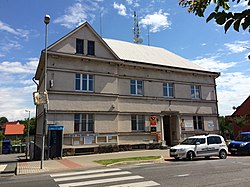
| image_caption = Municipal office |
| image_caption = Municipal office |
||
| image_flag = Flag of Mratín.jpeg |
| image_flag = Flag of Mratín.jpeg |
||
| image_shield = Coats of arms Mratín.jpeg |
| image_shield = Coats of arms Mratín.jpeg |
||
| ⚫ | |||
<!-- location --> |
<!-- location --> |
||
| subdivision_type = Country |
| subdivision_type = Country |
||
| Line 25: | Line 23: | ||
| coordinates = {{coord|50|12|11|N|14|33|4|E|display=inline,title}} |
| coordinates = {{coord|50|12|11|N|14|33|4|E|display=inline,title}} |
||
| coordinates_footnotes = |
| coordinates_footnotes = |
||
<!-- government type, leaders --> |
|||
| ⚫ | |||
| ⚫ | |||
<!-- established --> |
<!-- established --> |
||
| established_title = First mentioned |
| established_title = First mentioned |
||
| Line 35: | Line 36: | ||
| elevation_m = 192 |
| elevation_m = 192 |
||
<!-- population --> |
<!-- population --> |
||
| population_as_of = |
| population_as_of = 2023-01-01 |
||
| population_footnotes = <ref>{{cite web |title=Population of Municipalities – 1 January |
| population_footnotes = <ref>{{cite web |title=Population of Municipalities – 1 January 2023|url=https://www.czso.cz/csu/czso/population-of-municipalities-1-january-2023|publisher=[[Czech Statistical Office]]|date=2023-05-23}}</ref> |
||
| population_total = |
| population_total = 1462 |
||
| population_density_km2 = auto |
| population_density_km2 = auto |
||
<!-- time zone(s) --> |
<!-- time zone(s) --> |
||
| Line 53: | Line 54: | ||
| footnotes = |
| footnotes = |
||
}} |
}} |
||
'''Mratín''' is a municipality and village in [[Prague-East District]] in the [[Central Bohemian Region]] of the [[Czech Republic]]. It has about 1, |
'''Mratín''' is a municipality and village in [[Prague-East District]] in the [[Central Bohemian Region]] of the [[Czech Republic]]. It has about 1,500 inhabitants. |
||
==History== |
==History== |
||
| ⚫ | |||
{{stack|[[File:Mratín, Saint Michael church.jpg|thumb|150px|Church of [[Saint Michael]]]]}} |
|||
| ⚫ | |||
==Demographics== |
|||
{{historical populations |
|||
|align=none|cols=1 |
|||
|1869|530 |
|||
|1880|658 |
|||
|1890|781 |
|||
|1900|748 |
|||
|1910|764 |
|||
|1921|717 |
|||
|1930|905 |
|||
|1950|641 |
|||
|1961|626 |
|||
|1970|584 |
|||
|1980|541 |
|||
|1991|538 |
|||
|2001|570 |
|||
|2011|1256 |
|||
|2021|1464 |
|||
|source=Censuses<ref>{{cite web |title=Historický lexikon obcí České republiky 1869–2011 – Okres Praha-východ|url=https://www.czso.cz/documents/10180/20537734/130084150209.pdf/07595194-19df-4825-aa71-7137a5b31975?version=1.2|publisher=Czech Statistical Office|pages=7–8|language=cs|date=2015-12-21}}</ref><ref>{{cite web |title=Population Census 2021: Population by sex|url=https://vdb.czso.cz/vdbvo2/faces/en/index.jsf?page=vystup-objekt-parametry&z=T&f=TABULKA&sp=A&skupId=4429&katalog=33515&pvo=SLD21001-OB-OK|work=Public Database|publisher=[[Czech Statistical Office]]|date=2021-03-27}}</ref>}} |
|||
==References== |
==References== |
||
| Line 63: | Line 83: | ||
==External links== |
==External links== |
||
*[http://www.mratin.cz/ Official website] {{in lang|cs}} |
|||
*[http://www.mratin.info/ Information portal] {{in lang|cs}} |
|||
{{commons category|Mratín}} |
{{commons category|Mratín}} |
||
*{{official|https://www.mratin.cz/}} |
|||
{{Prague-East District}} |
{{Prague-East District}} |
||
| Line 75: | Line 94: | ||
{{ |
{{CentralBohemia-geo-stub}} |
||
Latest revision as of 10:58, 19 April 2024
Mratín | |
|---|---|
 Municipal office | |
| Coordinates: 50°12′11″N 14°33′4″E / 50.20306°N 14.55111°E | |
| Country | |
| Region | Central Bohemian |
| District | Prague-East |
| First mentioned | 1372 |
| Area | |
| • Total | 4.90 km2 (1.89 sq mi) |
| Elevation | 192 m (630 ft) |
| Population (2023-01-01)[1] | |
| • Total | 1,462 |
| • Density | 300/km2 (770/sq mi) |
| Time zone | UTC+1 (CET) |
| • Summer (DST) | UTC+2 (CEST) |
| Postal code | 250 63 |
| Website | www |
Mratín is a municipality and village in Prague-East District in the Central Bohemian Region of the Czech Republic. It has about 1,500 inhabitants.
History[edit]
The first written mention of Mratín is from 1372.[2]
Demographics[edit]
| Year | Pop. | ±% |
|---|---|---|
| 1869 | 530 | — |
| 1880 | 658 | +24.2% |
| 1890 | 781 | +18.7% |
| 1900 | 748 | −4.2% |
| 1910 | 764 | +2.1% |
| 1921 | 717 | −6.2% |
| 1930 | 905 | +26.2% |
| 1950 | 641 | −29.2% |
| 1961 | 626 | −2.3% |
| 1970 | 584 | −6.7% |
| 1980 | 541 | −7.4% |
| 1991 | 538 | −0.6% |
| 2001 | 570 | +5.9% |
| 2011 | 1,256 | +120.4% |
| 2021 | 1,464 | +16.6% |
| Source: Censuses[3][4] | ||
References[edit]
- ^ "Population of Municipalities – 1 January 2023". Czech Statistical Office. 2023-05-23.
- ^ "O obci" (in Czech). Obec Mratín. Retrieved 2020-11-05.
- ^ "Historický lexikon obcí České republiky 1869–2011 – Okres Praha-východ" (in Czech). Czech Statistical Office. 2015-12-21. pp. 7–8.
- ^ "Population Census 2021: Population by sex". Public Database. Czech Statistical Office. 2021-03-27.
External links[edit]
Wikimedia Commons has media related to Mratín.


