
Popovičky: Difference between revisions
Tom.Reding (talk | contribs) m Remove rendered gap(s) in {{Nav}}-block by moving non-{{Nav}}s outside; general cleanup & WP:GenFixes on |
etymology |
||
| (11 intermediate revisions by 4 users not shown) | |||
| Line 1: | Line 1: | ||
{{Expand Czech|date=July 2009|Popovičky}} |
|||
{{Infobox settlement |
{{Infobox settlement |
||
|name =Popovičky |
| name = Popovičky |
||
|other_name = |
| other_name = |
||
| settlement_type = [[Obec|Municipality]] |
|||
|native_name = <!-- for cities whose native name is not in English --> |
|||
<!-- images --> |
|||
|nickname = |
|||
| image_skyline = Popovičky, Svatý Bartoloměj church 2.jpg |
|||
|settlement_type =Municipality and village<!--For Town or Village (Leave blank for the default City)--> |
|||
| |
| image_caption = Church of Saint Bartholomew |
||
| image_flag = Flag of Popovičky.svg |
|||
<!-- images and maps -----------> |
|||
| |
| image_shield = Coat of arms of Popovičky.svg |
||
<!-- location --> |
|||
|imagesize = |
|||
| subdivision_type = Country |
|||
|image_caption = Church in Popovičky |
|||
| |
| subdivision_name = {{CZE}} |
||
| subdivision_type1 = [[Regions of the Czech Republic|Region]] |
|||
|flag_size = |
|||
| subdivision_name1 = [[Central Bohemian Region|Central Bohemian]] |
|||
|image_seal = |
|||
| subdivision_type2 = [[Districts of the Czech Republic|District]] |
|||
|seal_size = |
|||
| subdivision_name2 = [[Prague-East District|Prague-East]] |
|||
|image_shield = |
|||
<!-- maps and coordinates --> |
|||
|shield_size = |
|||
|image_map = |
| image_map = |
||
| |
| map_caption = |
||
| |
| pushpin_map = Czech Republic |
||
| |
| pushpin_relief = 1 |
||
| pushpin_map_caption = Location in the Czech Republic |
|||
|mapsize1 = |
|||
| coordinates = {{coord|49|57|45|N|14|35|52|E|display=inline,title}} |
|||
|pushpin_map = <!-- the name of a location map as per http://en.wikipedia.org/wiki/Template:Location_map --> |
|||
| coordinates_footnotes = |
|||
|pushpin_label_position =bottom |
|||
<!-- government type, leaders --> |
|||
|pushpin_mapsize = 300 |
|||
| leader_title = |
|||
|pushpin_map_caption =Location in the Czech Republic |
|||
| leader_name = |
|||
<!-- Location ------------------> |
|||
<!-- established --> |
|||
|subdivision_type = Country |
|||
| |
| established_title = First mentioned |
||
| established_date = 1352 |
|||
|subdivision_type1 = [[Regions of the Czech Republic|Region]] |
|||
<!-- area --> |
|||
|subdivision_name1 = [[Central Bohemian Region]] |
|||
| area_footnotes = |
|||
|subdivision_type2 = [[Districts of the Czech Republic|District]] |
|||
| area_total_km2 = 5.20 |
|||
|subdivision_name2 =[[Prague-East District]] |
|||
<!-- elevation --> |
|||
|subdivision_type3 = |
|||
| elevation_footnotes = |
|||
|subdivision_name3 = |
|||
| elevation_m = 377 |
|||
<!-- Politics -----------------> |
|||
<!-- population --> |
|||
|government_footnotes = |
|||
| |
| population_as_of = 2023-01-01 |
||
| population_footnotes = <ref>{{cite web |title=Population of Municipalities – 1 January 2023|url=https://www.czso.cz/csu/czso/population-of-municipalities-1-january-2023|publisher=[[Czech Statistical Office]]|date=2023-05-23}}</ref> |
|||
|leader_title = |
|||
| |
| population_total = 454 |
||
| population_density_km2 = auto |
|||
|established_title = <!-- Settled --> |
|||
<!-- time zone(s) --> |
|||
|established_date = |
|||
| timezone1 = [[Central European Time|CET]] |
|||
<!-- Area ---------------------> |
|||
| |
| utc_offset1 = +1 |
||
| timezone1_DST = [[Central European Summer Time|CEST]] |
|||
|unit_pref =Imperial <!--Enter: Imperial, if Imperial (metric) is desired--> |
|||
| |
| utc_offset1_DST = +2 |
||
<!-- postal codes, area code --> |
|||
|area_total_km2 = 5.19 <!-- ALL fields dealing with a measurements are subject to automatic unit conversion--> |
|||
| postal_code_type = Postal code |
|||
|area_land_km2 = <!--See table @ Template:Infobox Settlement for details on automatic unit conversion--> |
|||
| |
| postal_code = 251 70 |
||
| area_code_type = |
|||
<!-- Population -----------------------> |
|||
| |
| area_code = |
||
<!-- website, footnotes --> |
|||
|population_footnotes = |
|||
| |
| website = {{URL|https://popovicky.cz/}} |
||
| |
| footnotes = |
||
|population_density_km2 = |
|||
<!-- General information ---------------> |
|||
|timezone = [[Central European Time|CET]] |
|||
|utc_offset =+1 |
|||
|timezone_DST = [[Central European Summer Time|CEST]] |
|||
|utc_offset_DST =+2 |
|||
|coordinates = <!-- {{coord|||region:CZ_type:city|display=inline,title}} --> |
|||
|elevation_footnotes = <!--for references: use <ref> </ref> tags--> |
|||
|elevation_m =377 |
|||
|elevation_ft = |
|||
<!-- Area/postal codes & others --------> |
|||
|postal_code_type = Post code <!-- enter ZIP code, Postcode, Post code, Postal code... --> |
|||
|postal_code = 251 01 |
|||
|area_code = |
|||
|blank_name = |
|||
|blank_info = |
|||
|blank1_name = |
|||
|blank1_info = |
|||
|website = |
|||
|footnotes = |
|||
}} |
}} |
||
''' |
'''Popovičky''' is a municipality and village in [[Prague-East District]] in the [[Central Bohemian Region]] of the [[Czech Republic]]. It has about 500 inhabitants. |
||
==Administrative parts== |
|||
== Gallery == |
|||
The villages of Chomutovice and Nebřenice are administrative parts of Popovičky. |
|||
==Etymology== |
|||
The name is diminutive of Popovice. It was derived either from the personal name Pop, or from the old Czech word ''pop'' (i.e. 'priest'), meaning "the village of Pop's/priest's people".<ref>{{cite book |last=Profous|first=Antonín|title=Místní jména v Čechách III: M–Ř|url=https://mjc.ujc.cas.cz/search.php|page=436|year=1951|language=cs}}</ref> |
|||
==Geography== |
|||
Popovičky is located about {{convert|10|km|0|abbr=on}} southeast of [[Prague]]. It lies in the [[Benešov Uplands]]. The highest point is at {{convert|495|m|ft|abbr=on}} above sea level. The stream Chomutovický potok flows across the municipality. |
|||
==History== |
|||
The first written mention of Popovičky is from 1352. Chomutovice was first mentioned in 1205 and Nebřenice in 1437.<ref>{{cite web |title=Historie|url=https://popovicky.cz/obec/nase-obec/historie|publisher=Obec Popovičky|language=cs|access-date=2022-03-19}}</ref> |
|||
==Demographics== |
|||
{{historical populations |
|||
|align=none|cols=3 |
|||
|1869|279 |
|||
|1880|292 |
|||
|1890|283 |
|||
|1900|270 |
|||
|1910|280 |
|||
|1921|283 |
|||
|1930|334 |
|||
|1950|204 |
|||
|1961|193 |
|||
|1970|161 |
|||
|1980|144 |
|||
|1991|120 |
|||
|2001|154 |
|||
|2011|351 |
|||
|2021|505 |
|||
|source=Censuses<ref>{{cite web |title=Historický lexikon obcí České republiky 1869–2011 – Okres Praha-východ|url=https://www.czso.cz/documents/10180/20537734/130084150209.pdf/07595194-19df-4825-aa71-7137a5b31975?version=1.2|publisher=Czech Statistical Office|pages=9–10|language=cs|date=2015-12-21}}</ref><ref>{{cite web |title=Population Census 2021: Population by sex|url=https://vdb.czso.cz/vdbvo2/faces/en/index.jsf?page=vystup-objekt-parametry&z=T&f=TABULKA&sp=A&skupId=4429&katalog=33515&pvo=SLD21001-OB-OK|work=Public Database|publisher=[[Czech Statistical Office]]|date=2021-03-27}}</ref>}} |
|||
==Transport== |
|||
There are no railways or major roads passing through the municipality. |
|||
==Sport== |
|||
There is a modern [[golf course]] in Nebřenice.<ref>{{cite web |title=Golf|url=https://www.oaksprague.cz/en/golf-en/|publisher=Oaks Prague|access-date=2022-10-23}}</ref> |
|||
==Sights== |
|||
The landmark of Popovičky is the Church of Saint Bartholomew. The originally medieval church was completely rebuilt in the Baroque style in 1731–1736.<ref>{{cite web |title=Kostel sv. Bartoloměje|url=https://www.pamatkovykatalog.cz/kostel-sv-bartolomeje-2154671|publisher=National Heritage Institute|language=cs|access-date=2022-10-23}}</ref> |
|||
The Nebřenice Chateau was built as a hunting lodge in the early 19th century. Today, it is the seat of the golf clubhouse.<ref>{{cite web |title=History & Renovation|url=https://www.oaksprague.cz/en/our-estate/history-and-renovation/|publisher=Oaks Prague|access-date=2022-10-23}}</ref> |
|||
==Gallery== |
|||
<gallery> |
<gallery> |
||
Popovičky, upper common.jpg|Upper common |
|||
Popovičky, common.jpg|Lower common |
|||
</gallery> |
</gallery> |
||
==References== |
==References== |
||
{{reflist}} |
|||
{{Commons category}} |
|||
*''This article was initially translated from the Czech Wikipedia.'' |
|||
==External links== |
|||
{{commons category|Popovičky}} |
|||
*{{official|https://popovicky.cz/}} |
|||
{{Prague-East District}} |
{{Prague-East District}} |
||
{{Authority control}} |
|||
{{authority control}} |
|||
{{Coord|49|057|045|N|14|035|058|E|source:nlwiki_region:CZ_scale:50000|display=title}} |
|||
{{DEFAULTSORT:Popovicky}} |
{{DEFAULTSORT:Popovicky}} |
||
[[Category:Villages in Prague-East District]] |
[[Category:Villages in Prague-East District]] |
||
{{PragueEast-geo-stub}} |
|||
Latest revision as of 07:17, 10 February 2024
Popovičky | |
|---|---|
 Church of Saint Bartholomew | |
 Flag  Coat of arms | |
 Popovičky Location in the Czech Republic | |
| Coordinates: 49°57′45″N 14°35′52″E / 49.96250°N 14.59778°E | |
| Country | |
| Region | Central Bohemian |
| District | Prague-East |
| First mentioned | 1352 |
| Area | |
| • Total | 5.20 km2 (2.01 sq mi) |
| Elevation | 377 m (1,237 ft) |
| Population (2023-01-01)[1] | |
| • Total | 454 |
| • Density | 87/km2 (230/sq mi) |
| Time zone | UTC+1 (CET) |
| • Summer (DST) | UTC+2 (CEST) |
| Postal code | 251 70 |
| Website | popovicky |
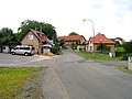
Popovičky is a municipality and village in Prague-East District in the Central Bohemian Region of the Czech Republic. It has about 500 inhabitants.
Administrative parts[edit]
The villages of Chomutovice and Nebřenice are administrative parts of Popovičky.
Etymology[edit]
The name is diminutive of Popovice. It was derived either from the personal name Pop, or from the old Czech word pop (i.e. 'priest'), meaning "the village of Pop's/priest's people".[2]
Geography[edit]
Popovičky is located about 10 km (6 mi) southeast of Prague. It lies in the Benešov Uplands. The highest point is at 495 m (1,624 ft) above sea level. The stream Chomutovický potok flows across the municipality.
History[edit]
The first written mention of Popovičky is from 1352. Chomutovice was first mentioned in 1205 and Nebřenice in 1437.[3]
Demographics[edit]
|
|
| ||||||||||||||||||||||||||||||||||||||||||||||||||||||
| Source: Censuses[4][5] | ||||||||||||||||||||||||||||||||||||||||||||||||||||||||
Transport[edit]
There are no railways or major roads passing through the municipality.
Sport[edit]
There is a modern golf course in Nebřenice.[6]
Sights[edit]
The landmark of Popovičky is the Church of Saint Bartholomew. The originally medieval church was completely rebuilt in the Baroque style in 1731–1736.[7]
The Nebřenice Chateau was built as a hunting lodge in the early 19th century. Today, it is the seat of the golf clubhouse.[8]
Gallery[edit]
-
 Upper common
 -
 Lower common


References[edit]
- ^ "Population of Municipalities – 1 January 2023". Czech Statistical Office. 2023-05-23.
- ^ Profous, Antonín (1951). Místní jména v Čechách III: M–Ř (in Czech). p. 436.
- ^ "Historie" (in Czech). Obec Popovičky. Retrieved 2022-03-19.
- ^ "Historický lexikon obcí České republiky 1869–2011 – Okres Praha-východ" (in Czech). Czech Statistical Office. 2015-12-21. pp. 9–10.
- ^ "Population Census 2021: Population by sex". Public Database. Czech Statistical Office. 2021-03-27.
- ^ "Golf". Oaks Prague. Retrieved 2022-10-23.
- ^ "Kostel sv. Bartoloměje" (in Czech). National Heritage Institute. Retrieved 2022-10-23.
- ^ "History & Renovation". Oaks Prague. Retrieved 2022-10-23.
External links[edit]
| Authority control databases: National |
|---|